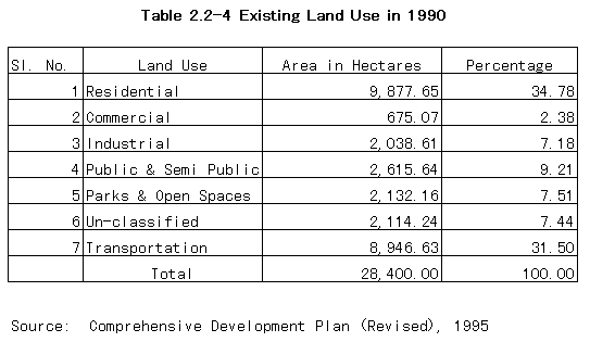
The detail of existing land use for Bangalore Local Planning Area surveyed in 1990 are indicated in Table 2.2-5. It shows that the residential use covers only 34.8% of the developed area. Commercial use covers 2.3% and are concentrated in the City Central Area, Cantonment Central Area, and Gandhinagar, M.G. Road, Bridge Road, Residency Road, Malleswaram Area, Ulsoor Area, Rajajinnagar Area, Gandhi Bazaar, Iayanagar Complex Area etc. Industrial use covers 7.2% of the developed area. Major industrial area are Hindustan Aircraft Limited, Indian Telephone Industries, Hindustan Machine Tools, Bharat Electronic Limited, Peeya Industrial Area, Rajajinagar Industrial Area, Mysore Road, Hosur Road and industrial area along the Highway.
Public and semi-public use covers 9.2% of the developed area. Public uses are concentrated around Vidhana Soudha, Indian Institute of Science, University of Agricultural Sciences, Bangalore University Area, Victria Hospital Area and near National Institute of Mental Health. Parks and Open specs cover 7.5%. Major spaces are Cubbon park, Lalbagh, Race Course, M.N. Krishna Rao Park and Bangalore Palace.
Areas under transportation occupy 31.5% of the development area. This include the area occupied by railways, roads, airport, railway stations and bus stations. The unclassified areas covering 7.5% are vast areas of defense land within the city