|
4 Services Provided
The objectives of REEFVTS are to:
・Enhance navigational safety in the Torres Strait and the inner route of the Great Barrier Reef by interacting with shipping to provide improved information on potential traffic conflicts and other navigational information;
・Minimise the risk of a maritime accident and consequential ship sourced pollution and damage to the marine environment in the Torres Strait and Great Barrier Reef region;
・Provide an ability to respond more quickly in the event of any safety or pollution incident.
In support of these objectives the following services are provided to shipping:
1. Ship Traffic Information;
2. Navigational Assistance;
3. Maritime Safety Information.
Much of the information processed by REEFVTS is collected from vessels in the area and hence mariners are cautioned that advisories based on such information are only as accurate as the provided information. Further, REEFVTS may not have first hand knowledge of all hazardous situations that exist in the REEFVTS area. Ships encountering a hazardous situation, such as a malfunctioning aid to navigation not already included in Maritime Safety Information should immediately advise REEFVTS.
4.1 Ship Traffic Information Through the integrated use of AIS, radar, APR via Inmarsat C and route plans provided by vessels, REEFVTS generates and disseminates ship encounter predictions in the form of Ship Traffic Information (STI).
Because of the extensive size of the area, REEFVTS does not routinely broadcast STI across the whole area but rather advises individual ships as necessary. In addition, REEFVTS will actively contact vessels to advise of any significant changes to STI.
Ships transiting the region receive STI under the following business rules:
・Upon entry to the REEFVTS area a ship will receive STI identifying the predicted ship encounters and Maritime Safety Information (Section 4.3) for the next six hours of their transit. As shown in the example below (using the Inmarsat C Messaging option described in Section 4.1.1) the STI identifies the vessel, the time and location of the predicted encounter.
Expected STI (EST):
Meet SILVER ZKANG (P) in your area now
Overtake ENDEAVOUR RIVER (P) at 10 1215
Meet FAR EASTERN SILO (P) at 10 1240
Meet GLORIOUS HALO (P) at 10 1325
Light altered Auscoast warning 340 at 10 30s 142 13e
Nardana Patches Buoy replaced by Beacon
Note: The meaning of phrases commonly used when STI is delivered are:
Pass - The word "Pass" is used to indicate that the ship is stopped.
Overtake - "Overtake" means that the ships are heading in roughly the same direction at the position of the predicted encounter.
Meet - The word "Meet" is used to describe all other situations.
(P) - Indicates piloted vessel
(NP) - Indicates a non-piloted vessel
(DD) - Deep Draught
・New/changed traffic information - After receiving the STI upon entry to the area REEFVTS monitors the transit of the vessel to identify any significant changes to the traffic information previously provided such as a new vessel, a change in ETA due to an increase or decrease in speed.
Where new or changed traffic information is predicted for a vessel, the vessel is provided with updated traffic information for the next six hours, identifying the predicted encounters as either:
- New;
- Changed or;
- Unchanged, that is where information provided previously has not changed.
Expected STI (EST):
Meet JAVA SEA (P) at 25 0755
(Changed) pass OOCL ENVOY (P) at 25 0925
(New) meet CHAMPION (P) at 25 1125
・5 Hour Update - Where a vessel has transited for a period of 5 hours without any new or changed traffic information predicted, the vessel is provided with updated traffic information for the next six hours as described under Upon Entry above.
The 5 Hour update will also indicate situations where there are no predicted ship encounters for the next six hours, that is, there is no new STI for the vessel.
4.1.1 Receiving Ship Traffic Information Mariners have the option to receive STI by one of two methods:
・Inmarsat C Messaging
Important Note: Ships who choose to receive STI updates by this method must:
- Provide REEFVTS the ship's Inmarsat-C terminal IMN to be used for email.
- Ensure that incoming messages from REEFVTS are read on receipt.
・VHF voice communications
Ships are reminded to maintain a listening watch on the appropriate channel frequency for that section of the REEFVTS area. Refer to section 5.2.2 for a list of channels and associated reporting points.
Note: Mariners are reminded that:
・Updated ship traffic information can be obtained at any time by contacting REEFVTS;
・They should advise REEFVTS if they are not receiving STI to arrange for an alternative means for the information to be provided (e.g. VHF communications).
4.2 Navigational Assistance In circumstances where information available to REEFVTS may assist on-board decision making, REEFVTS may initiate interaction with an individual ship.
This may include circumstances where information available suggests a ship may be standing into shallow water (e.g. in areas of restricted navigation where there is radar and/or AIS coverage) or deviating from a recommended route.
4.3 Maritime Safety Information (MSI) REEFVTS provides vessels with MSI relevant to their location and intended movement.
Should mariners notice a hazardous situation that may impact on the navigational safety of other vessels, this should be communicated to REEFVTS.
In addition, MSI is issued in the appropriate broadcasts from RCC AUSTRALIA in the form of navigational warnings (AUSCOAST Warnings).
5 Communication with REEFVTS 5.1 Vessel Operating Requirements Mariners shall comply with all measures established or directions issued by REEFVTS subject to the urgent needs or demands of safe navigation. If, in a specific circumstance, a mariner is unable to safely comply with a measure or direction issued by REEFVTS, the mariner may deviate only to the extent necessary to avoid endangering persons, property or the environment. The deviation shall be reported to REEFVTS as soon as practicable.
Mariners must ensure that a listening watch is maintained on the appropriate VHF radio channel as described in Section 5.2.2 of this User Manual.
The mariner must also maintain a listening watch on VHF radio channel 16 in the international maritime mobile band throughout the REEFVTS area.
5.2 Primary Communications The primary means of communication with REEFVTS:
a) Inmarsat C - messages sent to REEFVTS using special access code (SAC) 861 via the Perth LES (222) will be reverse charged to REEFVTS;
b) VHF Radio - Depending on a ship's position REEFVTS can be contacted on VHF channels 5, 18 or 19 (Radio call sign - REEFVTS) 24 hours a day.
The language to be used when communicating with REEFVTS is English, using the IMO's Standard Marine Communication Phrases where necessary.
Messages sent to REEFVTS will be reverse charged if ships use special access code (SAC) 861 via Perth LES (222). When setting up the Inmarsat C address book, select ASCII, or 7- bit or IA5 for data presentation or character code.
Note - Mariners are requested to ensure that Inmarsat C terminals are logged into the Pacific Ocean Region (POR).
Alternatively, messages can be sent to REEFVTS at a cost to the vessel to:
・telex +7146483
・email: reefvts@rcs1.amsa.gov.au
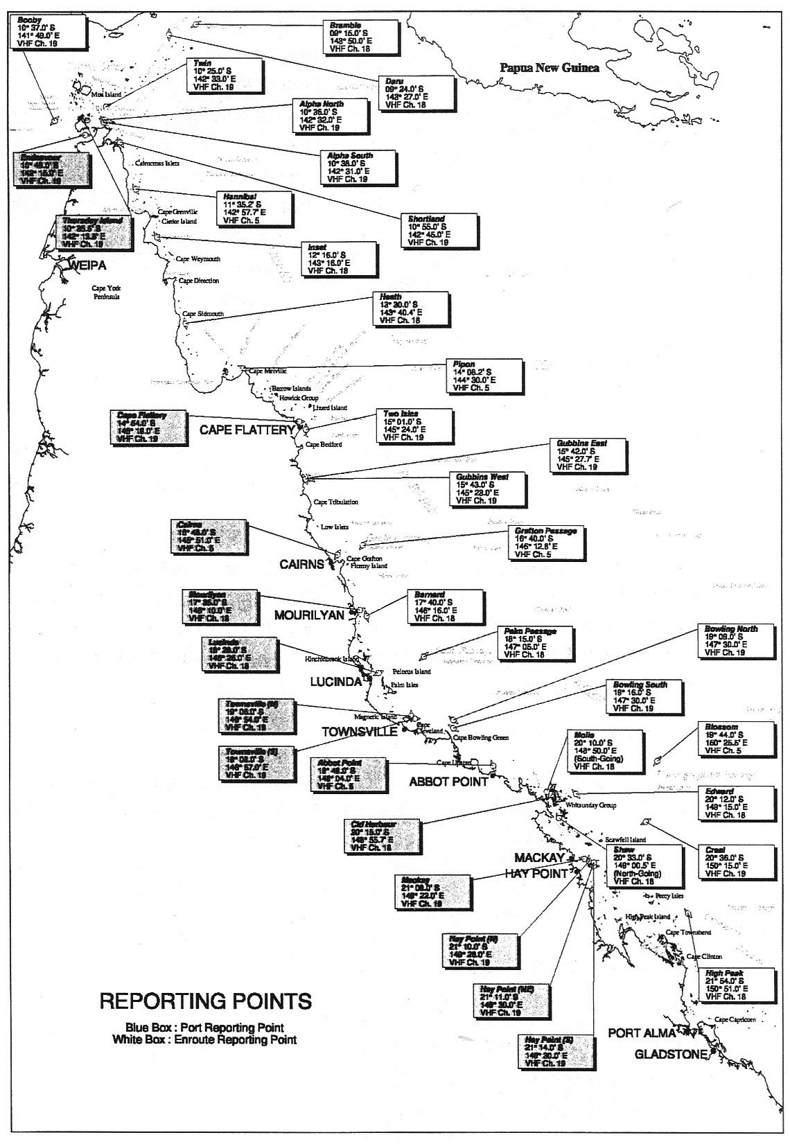
A VHF radio network is employed along the Queensland coast and on islands in the Torres Strait to allow mariners to communicate with REEFVTS. REEFVTS maintains a listening watch at all times on the working VHF radio channels listed below. The relationship between VHF channels and associated Mandatory Reporting points are dependant on a ship's position in relation to the area of that reporting point (Figure 2).
| Name of reporting point and AUS chart designation |
VHF Working Channel |
| Bramble (A) |
18 |
| Daru (B) |
18 |
| Twin (C) |
19 |
| Thursday Island (Dl) |
19 |
| Alpha North (F) |
19 |
| Booby (D) |
19 |
| Alpha South (G) |
19 |
| Endeavour (E) |
19 |
| Shortland (H) |
19 |
| Hannibal (I) |
5 |
| Inset (J) |
18 |
| Heath (K) |
18 |
| Pipon (L) |
5 |
| Cape Flattery (M1) |
19 |
| Two Isles (M) |
19 |
| Gubbins East (N) |
19 |
| Gubbins West (O) |
19 |
| Grafton Passage (P) |
5 |
| Cairns (P1) |
5 |
| Mourilyan (QI) |
18 |
| Barnard (Q) |
18 |
| Palm Passage (R) |
18 |
| Lucinda (R1) |
18 |
| Townsville-Nth (S1) |
19 |
| Townsville-Sth (S2) |
19 |
| Bowling North (S) |
19 |
| Bowling South (T) |
19 |
| Blossom (U) |
5 |
| Abbot Point (T1) |
5 |
| Molle (southbound) (V) |
18 |
| Edward (X) |
18 |
| Cid Harbour (V1) |
18 |
| Shaw (northbound) (W) |
18 |
| Creal (Y) |
19 |
| Mackay (Y1) |
19 |
| Hay Point-Nth (Y2) |
19 |
| Hay Point-NthEast (Y3) |
19 |
| Hay Point-Sth (Y4) |
19 |
| High Peak (Z) |
18 |
|
Mariners are reminded of the duty, only if practical, under the Safety of Life at Sea (SOLAS) Convention provisions to maintain a continuous listening watch on VHF radio channel 16 while at sea and for a radio watch to be maintained for broadcasts of MSI on the appropriate frequency or frequencies on which such information is broadcast for the area in which they are navigating.
5.3 Alternative Communications If for any reason communication is not possible via Inmarsat C or the appropriate VHF radio channel, the required information must be passed by alternative means to REEFVTS using one of the following:
a) Other INMARSAT phone/fax/telex service;
b) Other (non-Inmarsat) satellite phone/fax/telex service.
Contact details for REEFVTS are:
・Telephone +61 7 4956 3581
・Facsimile +61 7 4956 3367
・Telex +7146483
・Email: reefvts@rcs1.amsa.gov.au
Any failure of a ship's radio equipment that prevents the communication of required reports by either primary or alternative communication means is to be recorded in the ship's radio log book or the Official Log Book.
Vessels are requested to ensure that their AIS information is updated before entering the REEFVTS area. When setting a ship's name in an AIS transceiver, do not insert M/V or M/T prior to the ship's name. Following this advice will enhance the usefulness of AIS information at REEFVTS.
|
Figure 2: |
Mandatory Reporting Points and associated VHF channels
|
| (拡大画面:339KB) |
 |
|
|
|
|