|
○オーストラリアにおけるREEFREPの運用に関する調査資料
1 Australian Maritime Safety AuthorityとQueensland Government発行“Great Barrier Reef & Torres Strait Vessel Traffic Service (REEFVTS) User Manual”抜粋
| AIS |
Automatic Identification System |
| AMSA |
Australian Maritime Safety Authority established by the Australian Maritime Safety Authority Act 1990 |
| APR |
Automated Position Reporting via Inmarsat C |
| AUSREP |
means the Australian Ship Reporting System established under Division 14 of Part IV of the Navigation Act |
| Chemical tanker |
means a ship to which the BCH or IBC Code referred to in Marine Orders, Part 17 (Liquefied Gas Carriers and Chemical Tankers) applies |
| Combination carrier |
means a ship designed to carry either oil or solid cargoes in bulk |
| IMO |
International Maritime Organization |
| IMN |
Inmarsat Mobile Number |
| Length of tow |
means the distance between the stern of the towing vessel and the after end of the tow |
| Liquefied gas carrier |
means a ship to which the EGC, GC or IGC Code referred to in Marine Orders, Part 17 (Liquefied Gas Carriers and Chemical Tankers) applies |
| MSI |
Maritime Safety Information |
| MSQ |
Maritime Safety Queensland |
| Navigation Act |
means the Navigation Act 1912 |
| Oil tanker |
means:
(a) a ship constructed or adapted primarily to carry oil in bulk as cargo; or
(b) a combination carrier when it is carrying oil in bulk as cargo; or
(c) a chemical tanker when it is carrying oil in bulk as cargo; or
(d) any other ship fitted with cargo spaces which are constructed and used
to carry oil in bulk of an aggregate capacity of 200 cubic metres or more. |
| Overall length |
in relation to a ship, means the distance between:
(a) a vertical line passing through a point that is the foremost part of the stem; and
(b) a vertical line passing through a point that is the aftermost part of the stern; except that if the overall length of the ship cannot be so ascertained, the overall length is taken to be 110 per cent of the length as shown on the ship's load-line certificate. |
| REEFREP |
means the mandatory ship reporting system established by IMO Resolution MSC.52(66), as amended by Resolution MSC.161(78), and specified in Marine Orders, Part 56 (REEFVTS) Issue 2. |
| REEFVTS |
The Great Barrier Reef and Torres Strait Vessel Traffic Service (REEFVTS) established by Australia as a means of enhancing navigational safety and environmental protection in Torres Strait and the Great Barrier Reef. |
| SEI |
Ship Encounter Information |
| STI |
Ship Traffic Information (includes SEI and MSI) |
| VTS |
Vessel Traffic Service |
| VTSO |
Vessel Traffic Service Operator |
|
This manual is intended to provide users of the Great Barrier Reef and Torres Strait Vessel Traffic Service (REEFVTS) with information to assist them in optimising the service provided. For vessels subject to the mandatory ship reporting system within the area, the manual serves to aid the shipmaster's reporting obligations.
This manual is not intended to replace or alter any legislative requirements imposed by the Navigation Act 1912 in any respect to waters within the REEFVTS Area. Any apparent conflict between the manual and relevant legislation should be resolved in favour of the respective legislation.
Vessel traffic services provide the mariner with information relating to safe navigation in a waterway. This information, coupled with the mariner's compliance with regulations, guidelines and instructions, enhances the safe passage of vessels through congested waterways or waterways with particular hazards. Under certain circumstances, a Vessel Traffic Service Operator (VTSO) may initiate interaction with an individual ship and provide other information available to REEFVTS that may assist on-board decision-making. This may include circumstances where information suggests a ship may be standing into shallow water (e.g. in areas of restricted navigation where there is radar coverage) or deviating from a recommended route.
The master of a vessel remains at all times responsible for the manner in which the vessel is operated and manoeuvred, and is responsible for the safe navigation of the vessel under all circumstances.
Nothing in this manual is intended to relieve any vessel, owner, operator, charterer, master, or person directing the movement of a vessel from the consequences of any failure to comply with any applicable law or regulation or of any neglect of precaution which may be required by the ordinary practice of seamanship, or by the special circumstances of the case.
3 Great Barrier Reef and Torres Strait Vessel Traffic Service (REEFVTS) The environmental and cultural significance of the Great Barrier Reef (GBR) and Torres Strait region are nationally and internationally renowned. The protection of the outstanding natural qualities of the region was enhanced with the establishment of the Great Barrier Reef Marine Park in 1975. It was inscribed on the World Heritage List in 1981, and was designated by the International Maritime Organization (IMO) as the world's first Particularly Sensitive Sea Areas in 1990.
In 1996, REEFREP was established as an interactive mandatory ship reporting system which, in accordance with the International Convention for the Safety of Life at Sea (SOLAS) Chapter V regulation 8-1, that was formally adopted by the IMO under a Resolution of the IMO's Maritime Safety Committee (MSC52.66).
Since that time the Queensland and Australian Governments have established a suite of measures to assist in enhancing navigational safety, thereby minimising the risk of a maritime accident and consequential pollution and major damage to the marine environment from shipping incidents. The introduction of a Coastal Vessel Traffic Service (VTS) as a means to enhance navigational safety in Torres Strait and the GBR is one of these measures.
The Great Barrier Reef and Torres Strait Vessel Traffic Service (REEFVTS) is comprised of two major components:
1. A mandatory Ship Reporting System (the Great Barrier Reef and Torres Strait Ship Reporting System (REEFREP);
2. Monitoring and surveillance systems including radar, Automatic Identification System (AIS), Automated Position Reporting via Inmarsat C (APR) and VHF Reporting.
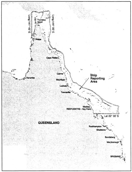
The area serviced by REEFVTS is the same area as defined for REEFREP (Figure 1) and includes:
a) The Torres Strait between longitude 141°45′ E and 144°00′E, including the Endeavour Strait and the Great North East Channel;
b) The waters of the Great Barrier Reef between the Australian coast and the outer edge of the Great Barrier Reef, starting from the outer edge of the Reef at latitude 10°44′S, longitude 144°00′E, and extending southwards to latitude 22°00′S.
Figure 1: REEFVTS area
REEFVTS is operated under joint Federal and State arrangements between the Australian Maritime Safety Authority (AMSA) and Maritime Safety Queensland (MSQ).
The system is manned and operated on a 24 hour a day basis by Maritime Safety Queensland personnel operating from the REEFVTS Centre, Radio Call Identity "REEFVTS" Radio Callsign "VZQ 641", situated at Hay Point near Mackay.
The VTSOs have completed the minimum competency standards of Certificate III VTS operations extending to Certificate IV Advanced Vessel Traffic Operations. These courses and standards have been provided and set by an accredited Maritime Training College and comply with the IALA Guidelines.
3.5 Mandatory Reporting Requirements Under the International Convention for the Safety of Life at Sea (SOLAS, Chapter 5) Governments may establish a VTS when, in their opinion, the volume of traffic or the degree of risk justifies such services.
The legislative basis for REEFREP is the general power within the Navigation Act to make regulations to implement SOLAS (s191), and the related power to make Marine Orders (s425(1AA)). Marine Order 56 is the resulting source of obligation.
3.5.1 Ships required to report to REEFVTS The following categories of ships are required to report to REEFVTS:
a) All ships of 50 metres or greater in overall length;
b) All oil tankers, liquefied gas carriers, chemical tankers or ships coming within the INF Code, regardless of length;
c) Ships engaged in towing or pushing where it, or the ship being towed or pushed is a ship described in a) or b) or where the length of the tow is or exceeds 150 metres.
Marine Order 56 applies to all ships in the categories set out above, irrespective of whether they are on overseas, interstate or intrastate voyages. Other vessels transiting the REEFVTS area are encouraged to report on a voluntary basis.
3.5.2 Warships, Naval Auxiliaries and Government ships SOLAS regulation V/8-1 does not apply to any warship, naval auxiliary or government owned or operated ship; however SOLAS does state that "such ships are encouraged to participate in ship reporting systems... adopted in accordance with this regulation".
This approach is fully supported by the Australian Government, and all ships of the Royal Australian Navy (RAN) are expected to participate in REEFVTS on a voluntary basis, along with other ships owned or operated by the Australian Government.
Any Master, or Officer of the Watch at the time, who fails to report in accordance with the reporting requirements, as specified in Marine Orders Part 56, or who wilfully transmits information which is incorrect, false or misleading, will have committed an offence subject to a penalty.
Regulation 4 of the Navigation (Orders) Regulations provides:
'4. A person who contravenes a provision of an order made under subsection 425(1AA) of the Act that is expressed to be a penal provision is guilty of an offence and is punishable, upon conviction:
(a) if the offender is a natural person-by an fine not exceeding $2,000: or
(b) if the offender is a body corporate - by a fine not exceeding $5,000.
|