|
(2) Vertical cross section of the equatorial Pacific
As a validation of zonally varying current structures and associated thermocline
depth and salinity distribution around the equator, we compared simulated fields with observational ones
( Fig.2 of Wyrtki and Kilonsky, 1984).
| (Enlarge: 74KB) |
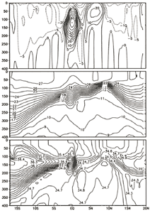 |
Figure 4. Simulated vertical cross sections of zonal velocity, isotherm
and salinity along the Hawaii-Tahiti line
Simulated annual means of the zonal current velocity, isotherm and salinity distributions are given in the upper, middle and lower panels in Figure 4. Those fields given in Figure 4 are the annual mean at tenth model year and no substantial changes were noticed in the following 40 years. The horizontal and vertical extents of the equatorial undercurrent are in good agreement with the observation and the maximum velocity appeared around the depth of 150 m reaches 80 cm/s, which is a little bit weaker than the observed value. The flow patterns extending to the northern and southern flanks of the undercurrent are also well simulated. The thermocline structure given in the middle panel, especially its accentuated contour intervals is very close to the observed structure except for the magnitude of meridional gradient around 5°N〜10°North. As to salinity field in the bottom panel, we noticed that the overall distribution pattern does not deviate considerably from the observational one. A closer inspection shows, however, that just the north of the equator there exists a thin lower salinity tongue extending downward at the depth around 200〜250 m and we are now checking whether it is the outcome of numerical noises or not. In spite of the existence of those detailed structures, we think that our simulation is successful in reproducing realistic vertical profiles of velocity, temperature and salinity fields and that the success is due not only to the employed high horizontal resolution but to high vertical resolution.
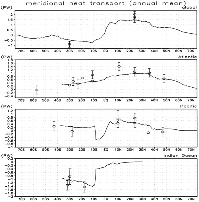
(3) Meridional heat transport
Realistic meridional heat transport is difficult to simulate with low horizontal
resolution model in which mesoscale eddy parameterization is not incorporated ( B ning
et al., 1995 ning
et al., 1995). Figure 5 shows the annual mean meridional heat transport calculated from our eddy-resolving
model. The maximum poleward heat transport in the northern and southern hemispheres turned out to be about
1.5 PW between 10 - 30°N and about 0.7 PW between 10 - 15°S respectively. Thus simulated meridional heat
transport pattern is not symmetric to the equator, while direct estimates based on hydrographic observations
( Hastenrath, 1982; Talley, 1984) and the indirect one using satellite
radiation and atmospheric reanalysis data ( Trenberth and Solomon, 1994)
also suggest an anti-symmetric pattern but with a lesser degree. This discrepancy is possibly due to the
underestimation of the southward heat transport in the South Pacific and/or the Southern Indian Ocean
(Figs.5c, 5d), though the southward heat transport in both the Pacific and the Indian Ocean derived from
the model is within the range of observed values.
The large latitudinal change of the heat transport can be seen in 8-10°S in
the Pacific and the Indian Ocean (Figs.5c, 5d). The amplitude reaches to about 0.9 PW, which is comparable
to the northward heat transport by the Gulf Stream in the North Atlantic (Fig.4b). This indicates that
the Indonesian Throughflow carries such a huge amount of heat from the Pacific to the Indian Ocean and
possibly affects the climate over the Indian Ocean. In the North Atlantic, the meridional heat transport
between 20 - 36°N is approximately 1 PW, which is similar to the estimation from the hydrographic observation
(Fig.4b). Such a large heat transport is attributed mostly to the northward transport of the warm water
by the Gulf Stream/the North Atlantic Current and to the southward transport of cold North Atlantic Deep
Water forming the Deep Western Boundary Current. B ning et al. (1995) showed that the horizontal
resolution is one of the crucial factors for a reliable estimate of the meridional heat transport. Actually,
heat transport in that region simulated with a coarse horizontal resolution of 1°turned out to be only
0.7 PW, while the same model with mesoscale eddy parameterization ( e.g. Gent and
McWilliams, 1990) can reproduce the northward heat transport of about 1 PW, which is comparable to
the one obtained in our eddy-resolving simulation.
| (Enlarge: 63KB) |
 |
Figure 5. Simulated annual mean heat transport, global(a), Atlantic(b),
Pacific(c) and Indian Ocean(d). Circles with error bars indicate the estimated heat transport from the
hydrographic observations based on Hall and Bryden (1982), Holfort and Siedler (1997), Macdonald and Wunsch
(1996), Rintoul and Wunsch (1991), Roemmich and McCallister (1989) and others referenced in Trenberth
and Caron (2001)
|