Vessels normally sail for their destination at sea speed according to
each navigation plan. A great high number of tracks were formed depending on the
configuration of an objective area. But, with reference to the results of researches on
actual traffic condition, it was found that these tracks were distributed in the
neighborhood of typical routes; similar vessels alter their course at similar place. Thus,
to simulate the path of each vessel, it was applicable to arrange course alteration area
in the objective sea area. A vessel would sail for its destination by way of these one
after another.
To reproduce the diversity of tracks, the concrete coordinate of the
next altering point of each vessel were given with normally distributed random numbers. Of
course, the location and range of each course alteration area was fixed with reference to
the results of an observation on actual conditions. Furthermore, flexibility in course
alteration was taken into account when a vessel was forced to make a collision avoidance
maneuver and deviates from its normal route.
3.2 SUB-MODEL 2: JUDGEMENT OF COLLISION
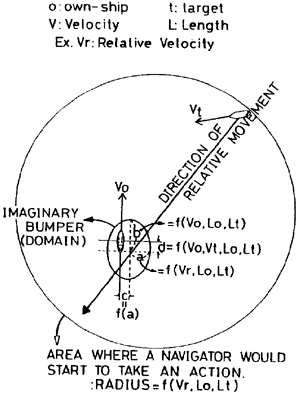
In order to judge whether a collision would take place or not in the
near future, it was checked whether the direction of relative movement of a target
infringed upon the area around one's own ship. The adopted shape of this area was an
ellipse which size was varied depending on velocity and length of both vessels.
Additionally, the location of the ellipse was shifted toward the starboard stern to
simulate the difference of the safety distance around a vessel.
This estimation was made when a target came in the area where a
navigator would start to take collision avoidance action. For simplification, a circle was
assumed as the shape of this area which size was varied depending on relative velocity and
length of both vessels as mentioned above. Considering the International Regulations for
Preventing Collision at Sea, the center of this circle was shifted toward the starboard
bow. An image of this sub-model is shown in Fig.5.
Fig.5 An image to explain the concept of collision judgment sub-model.
3.3 SUB-MODEL 3: MANEUVERING TO PREVENT A COLLISION
In congested sea area, it is considered that a navigator will not
analytically decide upon the optimum maneuver his decision making process seems rather to
be a case of empirical selection from various ways to prevent a collision. Thus, in this
simulation