indicating the volume of traffic crossing a optional line, a velocity
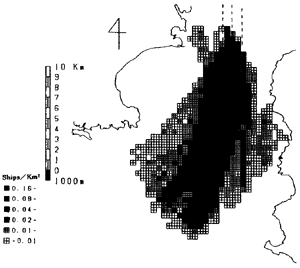
distribution chart and a traffic density chart which indicates the mean value of being
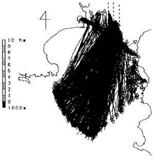
vessels in one square kilometer instantaneously. As an example, typical charts obtained
from an observation at the entrance of the Bay of Tokyo were shown in Fig.3 and Fig.4. In
this navigation area, a large number of vessels were gathering at the Uraga Traffic Route
and were scattering to various destinations from the traffic route, and so it will be
danger to navigate.
These results give us the useful information quantitatively, how many
vessels are passing through on what route, at how many speed and so on. However, an
observation seen from the outside like this can not show whether a navigator could accept
those traffic environment. Then a method putting oneself in navigator's place is necessary
to assess maritime traffic environment, and further, a computer simulation model should be
construct as a useful tool to estimate an influence of a future plan according with
construction projects at sea area; like the Akashi Kaikyo Bridge which is the longest
suspended bridge in the world.
Fig. 3 An example of an accumulated
tracks chart about all passing vessels
in one day.
Fig.4 An example of a traffic density
chart. (ships per one square kilometer)
3. SIMULATION MODEL TO MAKE UP MARITIME TRAFFIC FLOW
If there were no obstacles, vessels would go straight to their
destinations. When a collision would occur, a navigator maneuvers his vessel to avoid the
collision while he takes navigable water into account. That is to say, the movement of
each vessel is fundamentally linear, but spreads over a two-dimensional area in case of
necessity. Starting from this standpoint, a simulation model was constructed. In order to
faithfully reproduce the maritime traffic flow, five sub-models were built up
successively.(1)