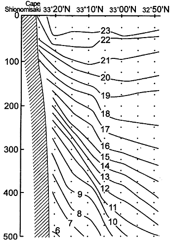
Fig.4. Temperature cross-sections (in ℃) along the north-south line (Line 2 in Fig.3) just south of Cape. Dots indicate the data points used for this analysis (Nagata et al., 1999b).
Due to an obstacle of the ADCP, no direct current information was available in this cruise. In the same period (on June 11-12), the R/V Wakayama of Wakayama Prefectural Fisheries Experimental Station occupied its routine observation lines in the vicinity of the Kii Peninsula, and CTD and ADCP observations were conducted. The observation points of these cruises are shown in Fig.3 together with the obtained temperature field at the depth of 200 m (the position of the isotherm of 15℃ at 200 m depth is the measure of the Kuroshio axis in this region). The temperature cross-sections along the north-south lines extending from Cape Shionomisaki (Line 2) is shown in Fig.4.
The high temperature gradients is seen just near Cape Shionomisaki in Figs.3 and 4, indicating that the strong eastward current of the Kuroshio was located very near to the cape. The temperature cross-section along Line 2, which runs in the north-south direction from just off Cape Shionomisaki, indicates that the strong current zone of the Kuroshio touched the coast and bottom slope just off Cape Shionomisaki. The surface current field at the depth of 5 m is shown in Fig.5. The current field at the depth of 50 m is almost identical to that at 5 m. The current velocities at 100 m are a little smaller than those at 5 m (up to about 10%).