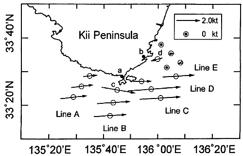
Fig.5. Surface velocity field measured by ADCP of the R/V Wakayama on June 11-12, 1996 (Nagata et al., 1999b). The locations of tide gauge stations Kushimoto and Uragami are shown with a and b, and the routine observation stations of Sta. 25 and Sta. 31 of Wakayama Prefectural Fisheries Experimental station with c and d, respectively.
It is hard to estimate the current velocity just above the bottom, but, if we simply extrapolate the measured current profile, the current velocities at 200 m or 300 m depths would exceed 1.0 m/s, and the vertically averaged velocity would reach 1.5 m/s in the strong current zone of the Kuroshio. These also indicate that the current zone of the Kuroshio touched the coast near Cape Shionomisaki, and that the Kuroshio current is quai-barotorpic and reaches the bottom.
It should be noted in Fig.3 that the Kuroshio in the vicinity of Cape Shionomisaki has a big east-west contrast in isotherm density, the densest portion of which corresponds to the current zone of the Kuroshio. To the east of the cape, the horizontal temperature gradient associated with the current zone is very sharp, and a clear shadow zone of the current is formed just east of Cape Shionomisaki, while the temperature field to the west of the cape is rather diffused. The temperature gradient across the Kuroshio increases from west to east in our observation area. The acceleration of the flow velocity of the Kuroshio near Cape Shionomisaki is also seen in the current field shown in Fig.5. The temperature field west of the cape suggests that the Kuroshio water intrudes well into the shelf region, and that the Kuroshio water covers almost whole coastal region southwest of the Kii Peninsula. This situation seems to be related to the Kii Bifurcation Current often found in this region as discussed later.
The situation shown in Fig.3 seems to be a representative feature of the Kuroshio when it takes the straight path, and the coastal waters to the west of Cape Shionomisaki is completely separated from that to the east. This separation would be essential to create the sea level difference between Kushimoto located to the west of the cape and Uragami located to the east of the cape.