|
Validation of Ship Motion Models in Shallow/Restricted Waters
Larry L. Daggett,(WST, USA)
John Christopher Hewlett (WST, USA)
Vladimir Ankudinov,(BMT D&P, USA)
Dennis Webb (US Army Engineer Research and Development Centers, USA)
Abstract: A number of studies and papers recommend more research to improve ship maneuvering predictions and validation of ship dynamics and squat/trim predictions in restricted waterways, especially utilizing advanced DGPS technology. The U.S. Army Engineers (USAE), in conjunction with National Ocean And Atmospheric Administration (NOAA) and Society of Naval Architects and Marine Engineers (SNAME), planned and conducted such ship measurements in the partially constructed Houston Ship Channel (HSC) to identify the effects of changes in channel width and depth on ship handling behavior. Results of this initial study are available to the marine community. The goal of this study was to verify ship simulation design studies, identify safe handling characteristics, and provide a database for future studies. Simulation studies are being conducted to verify ship maneuvering and squat/trim prediction models and develop methods to identify "safe" handling ships.
In the second phase of this study, mathematical models of several of these ships have been developed using two simulation modeling systems. Comparisons of the predicted response of these ships to controls in the modeled HSC will be presented and discussed. These comparisons allow an analysis of modeling straight-line control operations as affected by banks within a confined channel. This paper will present preliminary conclusions about the ability of predictive models to accurately compute the actual behavior of large ships in shallow and restricted channels and will make recommendations for further research.
1. BACKGROUND
Several studies in recent years have called for more full-scale data for ships maneuvering in restricted waterways. A Marine Board study [1] on the use of shiphandling simulation for waterway design in 1992 recommended research to improve the accuracy of mathematical models used for this purpose using physical scale models and computational fluid dynamics. It further identified the need to validate the resultant mathematical models with full-scale measurements of ship trajectories in restricted waterways. A PIANC study [2] published at about the same time came to the same conclusions and recommendations.
Another Marine Board study [3] noted that it is generally assumed that the database for mathematical simulators used for training is technically advanced enough to give accurate simulations of ship maneuvers in deep and unrestricted waters. However, it points out that the simulation of ship dynamics for shallow-water effects and ship-to-ship interactions are less technically advanced. It noted that full-scale real-ship experiments would advance the state of practice in modeling particularly for shallow water and restricted waters with banks.
The Draft Conclusions and Recommendations of the 22nd International Towing Tank Conference Maneuvering Committee meeting in May 2000 included several relevant statements. These include:
・There is evidence that maneuvers predicted using free-running model tests on full form ships can be subject to significant scale effects which are not yet well understood.
・Validation of simulations, and of free-running model test results, require benchmark data at full scale. DGPS measurements of squat provide a new source of data for validation of squat predictions.
・Based on the comprehensive collection of existing and new results, surprisingly large differences exist in published hull forces and moments for the Esso Osaka for both deep water and shallow water.
・The available data in its current form is not suitable for use as benchmark
・Work should be pursued to define the critical roll angle values above which 4-degrees-of-freedom are needed in simulation.
・Research is needed to improve the accuracy of practical prediction methods, including numerical methods, for squat.
・Trials dada for all ship types at fully loaded condition should be collected to support evaluation of IMO standards.
・Research is required to quantify scale effects on hydrodynamic forces acting on a maneuvering vessel, particularly the lateral forces and yawing moments.
・Clarification is required to quantify scale effects present in free-running models.
・Standardized precision limits should be provided with both predictions and full-scale results. "Good agreement" should be defined based on these precision limits.
・The lack of benchmark data for all maneuvering problems needs to be addressed by conducting suitable (free-running and captive) benchmark quality tests at model and full scale.
・Promote the disclosure of benchmark data through the organization of a workshop.
During the Second Faderal Waterways Management Research and Development Coordination Conference held at the U.S. Coast Guard Academy in 1993, there was general agreement that full-scale measurements of ships maneuvering in real waterways with restricted channels would allow advancements in waterway safety and efficiency. During workshops the possibility of making such measurements in the Houston Ship Channel was discussed This project was of particular interest since it is one of the few highly restricted waterways with a high volume of traffic, straight channel segments, and a relatively mild environment, i.e. moderate tide and current conditions in the bay.
The National Ocean Service (NOS) has likewise demonstrated the capability to successfully measure ship behavior to high degrees of accuracy in measurements in San Francisco Bay. A containership and tanker have been instrumented with DGPS and accelerometers and all six-degrees of motion of the ship have been measured for several transits into and out of San Francisco Bay [4].
2. HOUSTON SHIP CHANNEL SHIP MOTION MEASUREMENTS
SNAME proposed a project to collect ship maneuvering data in the HSC prior to completion of the ongoing project improvement program [5] and this proposal was discussed in detail at MARSIM 2000. The USAE and NOAA funded this project and it was performed in July 2001[6]. The purpose of this effort was to record and document data that defines ship motions (both horizontal and vertical) during transits in the Houston Ship Channel, particularly the Galveston Bay reaches, and the relevant environmental and ship control factors that influence these ship motions. These measurements combined with ship characteristics and channel conditions provide data that can be used to better understand ship behavior and controllability in confined waterways and to verify numerical ship models. Since the ships measured operated through both a 400-ft × 40-ft (122 m x 12 m) channel, and a 530-ft × 45-ft (165 m x 13.7 m) channel, these measurements will provide comparative data in two channel sizes. The results are useful for improving the safety of present and future operations in the Houston Ship Channel. Only limited processing and analysis of these data has been performed and further work is required to fully utilize these data, especially for vertical motions, e.g., squat and heel. The report on this project is available on the SNAME web site and the data are available on request.
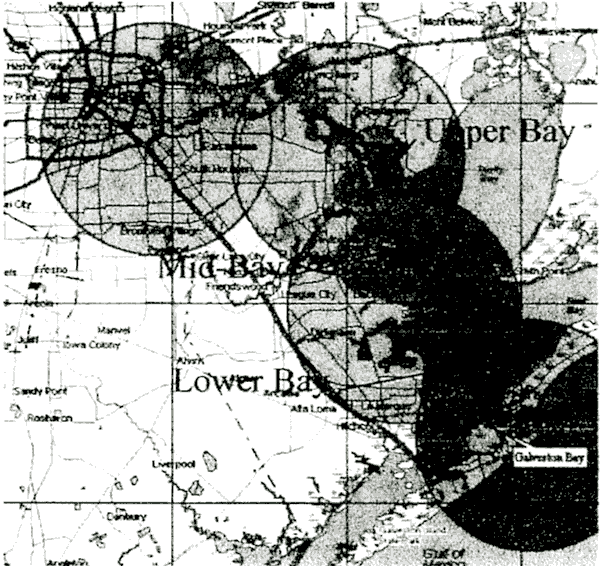
The collection of accurate position (vertical and horizontal) data on ships in Galveston Bay from Barbers Cut to the intersection with the Gulf Intracoastal Waterway was the focus of this study,Figure 1. In addition, hydrographic data, water level, wind, and ship descriptive parameters, controls, and maneuvering characteristics were collected. From these data, ship tracklines, sinkage, and trim were computed. All records, data (both raw and reduced) and notes were organized and have been made available in Microsoft Excel worksheets in order to prepare for further analysis of these data in future studies.
The data collection effort focused on two ship types:
containerships and tankers, specifically focusing on wide-bodied" ships, those with over 120 ft (36.6 m) beams. Wide-bodied ships generally had beams of 135-138 ft (41-42 m). These ships primarily operated from Shell Oil, Oil Tanking, Houston Fuel Oil, and Exxon Baytown terminals and were tankers. The widest beam containerships were Panamax widths of 106 ft and they all were serviced at Barbours Cut terminals. In addition, there was a desire to measure ships for more than one transit if possibie. Therefore,if a ship was measured inbound, then that ship was targeted for measurement on its outbound transit if possible. As the data collection progressed, the ship combinations measured were checked and ships were selected to assure that all combinations of ship type meetings could be measured to the degree possible.
In order to select the ships to meet, the pilot's guidance for allowing ships to meet in the navigation channel had to be considered. Ships with combined beams less than 290 ft (88.4 m) are allowed to pass in the new channel below channel markers 49 and 50. Above that point in the channel ships with combined beams less than 251 ft (76.5 m) are allowed to pass. Therefore, in order to measure meeting situations with ships with the widest beams, generally about 138ft (42 m), these ships had to meet in the reach below Eagle Point. These large ships were generally restricted to daylight sailings.
Ships measured included:
・25 ship transits were recorded including:
o 13 tankers/bulk carriers
o 9 containerships
o 2 OBO
o 1 general cargo ship
・11 transits had beams greater than 39.3 m
・9 meetings with both ships instrumented
o 4 had combined beams <= 64.6 m
5 had combined beams > 73.1 m
Fig.1 |
Houston Ship Channel with Bay Reaches and GPS Base Station Locations and Range of Coverage |
3. RECOMMENDAIIONS FOR VALIDAIION
SNAME has approved a research project to develop a test program to determine parameters and maneuvers to identify ship handling parameters in response to a request from the Houston Ship Pilots [7]. This research project has two phases. The first phase, which has been funded, involves identifying the ships for which sufficient data are available to develop a mathematical model for use in a simulator, validate the ship model once it is developed, determine methods by which the prototype data might be used directly to identify ship-handling characteristics, identify missing data that, if obtained, would greatly enhance the success of the study (e.g., additional ship data from the owner/operator),and develop a study approach and cost estimate for the second phase of the project. The second phase is expected to involve the development of several ship models of the measured ships, validation of these models against the measured HSC ship motions and controls, and the conduct of a systematic test series to identify ship parameters that seem to be critical for identifying the handling characteristics of ships proposed to enter the improved HSC. The initial validation activities will involve the Corps of Engineers ship modeling system.
3.1 Considerations
An evaluation of the data available from the HSC measurements has resulted in recommendations for segments of ship transits that can be analyzed in detail and modeled using available ship simulation models. These test sets were selected based on:
・Availability of ship position, orientation, and control data,
・Ships of particular interest, e.g., wide bodied tankers,
・Maneuvers of special interest, e.g., meeting of two instrumented ships, mini-zig-zag maneuvers, controlled movement along the bankline or off-centerline of the channel.
3.2 Ships Modeled
Selected ships have been modeled for the Corps of Engineers ship simulator [7]. These ships are listed in Table 1. A comparison of the standard maneuvers to available ship trial data are shown in Table 2.
Table 1 Ship Models Developed
| Name |
Type |
Length
(m) |
Beam
(m) |
Avg.
Draft
(m) |
| New Amity |
Tank. |
241 |
42 |
12.0 |
| New Amity |
Tank. |
241 |
42 |
8.5 |
| MSC Sabrina |
Cont. |
242.6 |
32.3 |
10.7 |
| SL Performance |
Cont. |
289.6 |
32.3 |
9.1 |
| Frankopan |
Tank. |
244.2 |
39.3 |
8.5 |
| SL Pride |
Cont. |
261 |
32.3 |
9.1 |
| Sibohelle |
Tank. |
246 |
32.3 |
12.2 |
|
3.3 Navigation Channel Models
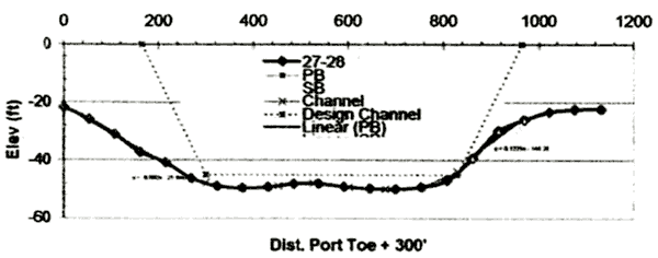
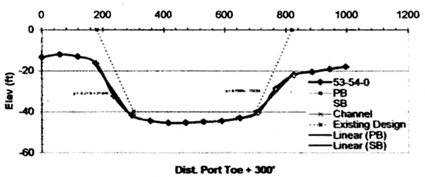
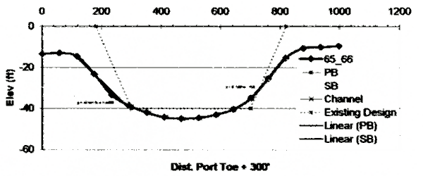
The trench-type channel in the Bay has three straight channel reaches. Above channel markers 51 -52 the reaches have the unimproved dimensions and below the channel has been widened and deepened. The general shape of this channel is shown in Figures 2,3 and 4. Three models of this channel were developed to test the effects of detailed modeling of the channel dimensions and bank conditions.
Table 2 Comparison of Measured and Simulated Ship Trial Data for the New Amity
| Check Items |
Prototype |
Simulated |
| Port |
Strb |
Port |
Strb |
| 10-10 Zig-Zag |
1stOvershoot
Angle(deg) |
8.3 |
7.8 |
9.2 |
7.8 |
2ndOvershoot
Angle(deg) |
16.1 |
17.9 |
14.4 |
16.2 |
| 20-20 Zig-Zag |
1stOvershoot
Angle(deg) |
11.8 |
11.0 |
11.4 |
|
| Turning Test |
| Transfer(m) |
281 |
324 |
256 |
263 |
| Advance(m) |
689 |
692 |
682 |
692 |
Tactical Dia.
(m) |
625 |
685 |
643 |
660 |
| Time to 90 |
1'58" |
2'5" |
2'01" |
2'03" |
| Time to 180 |
4'17" |
4'20" |
4'12" |
4'17" |
|
The bank conditions were modeled by defining the bank angle and the water depth on the overbank, i.e., the minimum depth on the left and right side of the channel. The first model, Base, only identified the channel by defining cross-sections at locations with significant changes in the banks of channel width/depth and at each channel marker location, about intervals of 4000 ft ( l.2km). The second and third models were developed from cross-sections spaced at 1000 ft (305 m) and 500 ft (152m) intervals and are identified as 1000-ft and 500-ft models.
Several of these ship model characteristics are close enough to other ships recorded that they can be used to represent these ships in validation testing. For example, the loaded New Amity, model can be used to represent these ships: Genmar Agamemnon (243.3×41.8×ll.9), Nissos Amorgos (243.9×42.1×11.3),SKS Trinity(243.9×42.1×12.2)
Fig.2 |
Cross-section at Lower Bay Channel Markers 27-28 showing Design Channel and Digitized Depth and Bank Slopes |
The USAE fast-time ship simulation modeling system was used to perform initial simulation testing.
Fig3 |
Cross-section at Mid-Bay Channel Markers 53-54 showing Design Channel and Digitized Depth and Bank Slopes |
Fig.4 |
Cross-section at Mid-Bay Channel Markers 65-66 showing Design Channel and Digitized Depth and Bank Slopes |
3.4 Measured Ship Motions Recommended for Detailed Validation Analysis Using Ship Simulator Models
The events selected for use in validation testing are listed below:
・New Amity performing a Zig-Zag maneuver between Buoys 26 and 42
・New Amity meeting New Alliance
・SKS Trinity meeting Frankopan
・SKS Trinity Maneuver to Quarter Channel
・Frankopan Special Maneuvers
・New Amity outbound - CL to Right Toe Maneuver
Examples of the ship motions measured during these maneuvers are given in Figures 5 and 6.
|