|
PASSAGE PLANNING SYSTEM FOR SMALL INLAND VESSELS
BASED ON STANDARD PARADIGMS AND MANEUVERS OF EXPERTS
Makoto Endo (Toyama National College of Maritime Technology, Japan)
Kazuhiko Hasegawa (Osaka University, Japan)
Abstract: The authors have developed the passage planning system for small inland vessels. In this paper, algorithms, models and simulator studies on the passage planning system are discussed. The proposed passage planning system consists of following three sub systems; 1) Route planning system, 2) Maneuver planning system and 3) Real-time maneuvering information support system. Simulations of the passage planning system show that the system can generate the good passage plan automatically. Simulator studies by navigators using the real-time maneuvering information support system based on the passage planning system also shows the good tracking performance.
1. INTRODUCTION
When a large vessel enters and leaves a port, a pilotage by a pilot is provided to the vessel with a legal basis. This pilotage keeps the safety operation of the vessel and contributes the safety and effective port operation. But in Japan, almost 10 or more times as many as the number of legal piloted vessels have accessed ports. Almost all of them are small inland vessels which have no legal basis on not only pilotage but also VTS: Vessel Traffic Service and AIS: Automatic Identification System. Many marine accidents on the small inland vessels had been occurred in and around Japanese ports. From a viewpoint of safety port operation and efficient traffic management, maneuvering assistance for whole vessels, including small inland vessels, should be provided.
If real-time information of an appropriate planned passage, like a pilotage, for each small inland vessel is provided to the vessel, her operator can maneuver the vessel more safely and without any delay. In order to realize this real-time maneuvering information support system based on the appropriate planned passage for a small inland vessel, the authors has tried to develop the passage planning system [3,4,5,6]. In this paper, system configuration of the passage planning system, algorithms and models, which were developed and used in the system, are introduced. Simulations and simulator studies, which were executed in order to verify the passage planning system, were also reported.
2. STANDARD PASSAGE PLANNING PARADIGM
The paradigm of passage planning by expert and skillful mariners are investigated by questionnaire surveys, passage planning experiments and simulator studies. Expert captains have many experiences to maneuver vessels. Pilots have not only many experiences to maneuver vessels but also much priori knowledge on the target port and area. A passage planning for a vessel in a water area should be produced based on these priori experiences and knowledge. A passage plan has to include a route plan and a maneuvering plan. The standard passage planning consists of two sub-plannings. One is route planning and the other is maneuver planning.
(1) Planning a route
A route from the origin to the destination should be planned in according with planning guidelines, such as UKC, distance off, recommended and legal passage, etc. This route is a chain of elemental passages. Each elemental passage is defined by its course, width and length of its Safe Water. For planning a route, the priori knowledge on the target water area is necessary.
(2) Planning maneuvers
A maneuvering plan is to maneuver a vessel along with the planned course and speed. Maneuvers of vessels are classified into some kinds of elemental maneuvers, such as course alteration, turning, stopping, etc. This maneuvering plan should be composed of a chain of elemental maneuvers and maneuvering orders. For planning maneuvers, the priori knowledge on maneuverability characteristics of the vessel is needed.
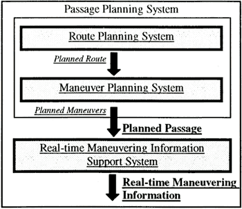
Based on the above-mentioned standard passage planning paradigm of expert and skillful mariners, the passage planning system should consist of the route planning system, the maneuver planning system and the real-time maneuvering information support system, as shown in Figure 1.
Fig.-1 |
System Configuration of the passage planning system |
3. ROUTE PLANNING SYSTEM
A rational method to plan routes was found by investigating standard methods and guidelines on route planning. This rational route planning methods consists of following 4 steps.
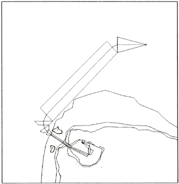
1st Step: Definition of the topographical constraints. the init and the goal
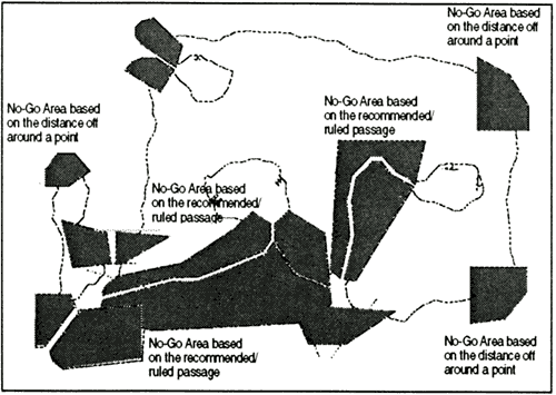
The No-Go Areas should be defined based on a database of topographical constraints on the target water area. Figure 2 shows an example of the defined No-Go Areas.
2nd Step: Planning the shortest path
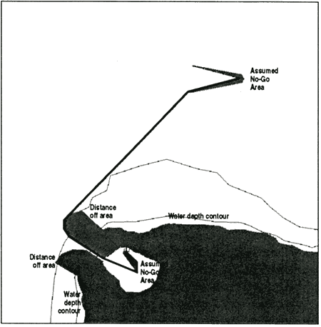
Using the Visibility Graph method [7], a shortest path from the init to the goal through the free area except the No-Go Area should be found. Figure 3 shows an example of the found shortest path.
3rd Step: Planning a chain of elemental Safe Waters
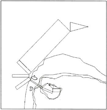
In order to maximize the clearance between the ship and the No-Go areas, elemental Safe Waters along the shortest path should be found. Figure 4 shows an example of the chained elemental Safe Waters.
4th Step: Planning a chain of elemental passages and the route
In order to keep the continuity of the passages, elemental Safe Waters should be transformed into elemental passages. The route, which keeps the enough clearance to the No-Go Area like as the Voronoi diagram method [7], should be planned. Figure 5 shows an example of the chained elemental passages and the planned route.
Fig. 2 |
The No-Go Area based on the topographical constraints, such as water depth, distance off areas around points and recommended/ruled passages |
Fig. 3 |
The shortest path planned under the No-Go Area constraint which consists of the water depth contour, distance off areas and assumed No-Go |
Fig. 4 |
A chain of elemental Safe Waters along the shortest path |
Fig. 5 A chain of elemental passages and the route
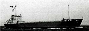
Photo 1 GT499 inland vessel
|