|
4.3 Simulation Program
The design ship for simulations conducted for the Arthur Kill Dredging Project was the SL Performance and the 132,000 dwt tanker used in the Arthur Kill Deepening Study.
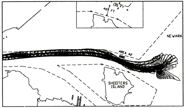
Area A2 is the easternmost of the dredging areas modeled and is just north of Shooter's Island. The existing channel is 600 ft wide. The area to be buoyed off is approximately 135 ft wide, leaving nearly 465 ft of channel for ship traffic. Simulations were conducted inbound and outbound for flood and ebb tide. Figure 18 shows the flood tide run with the SL Performance backing out and turning in Newark Bay.
Figure 19. Sample track plot, Area A2
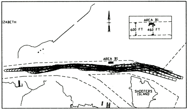
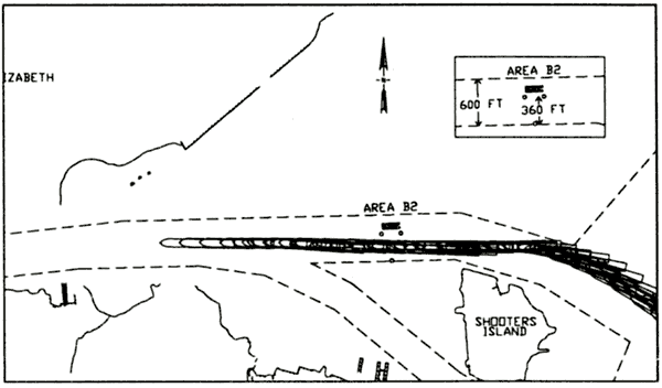
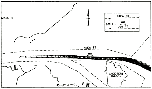
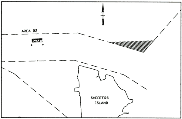
Three sections were modeled for Area B. These are Areas B1, B2, and B3. Area B1 encroaches the least upon the existing channel and Area B3 encroaches the most. The existing channel is 600 ft wide. Area B1 reduces that width by approximately 140 ft, to a navigable width of 460 ft. Area B1 was simulated for outbound transits only. Since Area B1 affords the widest channel, it is assumed that if Areas B2 and B3 are acceptable for the easier inbound runs, Area B1 will also be acceptable. Area B2 fall between Areas B1 and B3. Area B2 reduces that width by approximately 240 ft, to a navigable width of 360 ft. Area B2 was simulated for both inbound and outbound runs. Area B3 provides the narrowest navigation channel, 260 ft. Because of Area B3's width, no outbound simulations were attempted.
Figure 20 shows an outbound run in flood tide passed the dredge in area B1. All vessels successfully passed the dredge, but several left the north side of the channel at the end of North of Shooter's Island Reach.
Figure 20. Outbound Area B1
Figure 21 shows an inbound run in flood tide passed the dredge in area B2. All vessels successfully passed the dredge. One ship left the north side of the channel at the end of North of Shooter's Island Reach. Several outbound runs were attempted with the SL Performance backing past the dredge. The pilots considered this scenario extremely difficult. One backing ship struck the dredge.
Figure 21. Inbound Area B2
The narrowest area, B3 is shown in Figure 23. The runs in this track plot were conducted during flood tide. The ships were able to line up for the constricted channel early and successfully passed the dredge. No outbound runs were attempted for this scenario because the B3 channel was too narrow to seriously consider this option.
Figure 22. Inbound Area B3
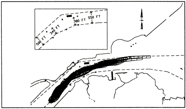
Area D6 is located in the bend between North of Shooters Island Channel and Elizabethport Channel. North of Shooters Island Channel is 550 ft wide at its western end. Area D6 reduces the channel width there to approximately 380 ft. Elizabethport Channel is 550 ft wide and is reduced to approximately 340 ft by Area D6.
The composite plot of all ships backing past the dredge in area D6 is shown in Figure 23. One ship slightly crossed the north channel edge after passing the dredge. The remainder of the runs were successful.
Figure 23. Outbound Area D6
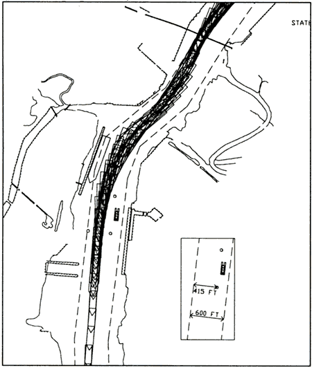
Area K1 is the most inland of the dredge locations. It is located just southwest of Tosco. The authorized channel is 600 ft in that reach. Area K1 reduces the channel width there to approximately 415 ft. A smaller 750-ft long tanker with a beam of 120 ft and a draft of 36 ft was used to model tankers that call at any of a number of refineries south of Tosco.
The tracks for all these tankers passing dredge area K are shown in Figure 24. All tankers successfully completed the exercise.
A detailed description of all simulator results for Arthur Kill is beyond the scope of this paper. Full results are included in the projects technical report (Webb, in preparation).
Figure 24. Inbound Area K
4.4 Arthur Kill Dredge Conclusions
Area A2. Although several of the simulations show ships crossing over the buoy line into the restricted area, the pilots did not have significant problems maneuvering around Area A2. All pilots stated in the final questionnaire that any difficulties could be resolved with additional tug support.
Areas B1, B2, and B3. None of the pilots had any major difficulties backing around Area B1. The pilots were able to go inbound though the narrower opening provided by Area B2. Therefore, Area B1 is acceptable for navigation both inbound and outbound.
The pilots often came very close too or actually left the channel on the northern side of North of Shooter's Island Reach, where in intersects Newark Bay. The problem is the southern alignment shift. It was recommend that the portion of the new widening that is in line with the buoys of Area B2 be completed and marked with buoys prior to the construction of Area B2, as shown in Figure 25. This would allow inbound ships to line up sooner for Area B2 and give outbound ships a little more room to recover from Passing Area B2.
The pilots had difficulties on a number of the simulations of Area B3. Even though some runs were successful, the pilots stated in their final questionnaire that they felt the maneuver was unsafe. Area B3 is not recommended for use.
Figure 25. Recommended widening for Area B2
Area D6
The pilots had some problems making it through the bend with Area D6. These concerns are echoed in their final questionnaires. Most of the pilots feel that the proposal is do-able, but will require extra tugs. Further testing may be required.
Area K1.
Area K1 did not cause any problems for transiting ships.
REFERENCES
[1] Feasibility Report for the New York and New Jersey Harbor Navigation Study, December 1999
[2] McVan, Darla. Hydrodynamic Modeling of New York Harbor, in preparation
[3] Webb, Dennis. Port Jersey 50-ft Channel Navigation Study, in preparation.
[4] Webb, Dennis. Arthur Kill 50-ft Channel Navigation Study, in preparation.
[5] Webb, Dennis. Arthur Kill Dredge Location Study for 42-ft Channel Improvements, in preparation.
AUTHOR'S BIOGRAPHY
Dennis Webb is currently the Leader of the Ship Simulation Group at U. S. Army Corps of Engineers - Engineer Research and Development Center (ERDC) in Vicksburg, MS. He has conducted numerous simulator-based channel design projects over the past 15 years. He has also been responsible for several field data collection exercises using DGPS receivers to record real-world ship motion. He received MS and BS degrees in civil engineering from the University of Missouri.
Frank Santangelo, P.E. is currently Team Leader of the Hydraulics and Hydrology Team at the U.S. Army Corps of Engineer, New York District. He has completed numerous deep draft navigation channel design studies for various channels throughout the Port of New York and New Jersey. He received a BE degree in Civil Engineering from The Cooper Union, and MS degree in Civil Engineering from Polytechnic Institute of New York.
|