|
資料1
The objective of the Channel Navigation Information Service (CNIS) is to contribute to the safety of navigation within the Dover Strait by:
・Encouraging vessels to comply with International Maritime Organization (IMO) procedures for vessels navigation within a Traffic Separation Scheme (TSS).
・The provision of the latest information to shipping on activities, conditions and navigational irregularities which may affect safe navigation.
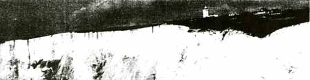
The Dover Strait
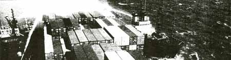
The Dover Strait is one of the busiest international seaways in the world , regularly used by over 100 commercial vessels daily
It became the first IMO approved Traffic Separation Scheme (TSS) in the world in the early seventies and was the first to come under full radar surveillance. The Channel Navigation Information Service (CNIS), introduced in 1972, provides a 24 hour radio and radar safety service for all shipping in the Dover Strait. It is jointly operated by the UK and French Administrations from the Dover Maritime Rescue Co-ordination Centre (MRCC) and CROSS Gris Nez in France. The Dover Strait is a mandatory reporting area, under regulation, vessels over 300 gross tonnes are required to make report to either Dover MRCC (SW Lane) or CROSS Gris Nez (NE Lane) before proceeding through the service area.
The Dover CNIS system has been refurbished and has introduced the latest radar and Vessel Tracking System technology combined with data fusion from other sensors including Automatic Identification System (AIS) transponders and Very High Frequency Direction Finding (VHFDF). A comprehensive project in itself, CNIS has been delivered in conjunction with the Integrated Coastguard Communication System (ICCS) and the Information Management System (IMS) to make Dover one of the most advanced Coastal Vessel Traffic Services in the world.
The functions of CNIS are to keep the Dover Strait TSS under observation, to monitor the flow of traffic and to detect and report vessels which contravene the International Regulations for Preventing Collisions at Sea 1972, as amended (COLREGS). The UK responsibility for operating CNIS is vested in HM Coastguard at Dover MRCC. The modern technology installed will support the MCA and HM Coastguard in promoting Safety of Life at Sea, enhance Counter Pollution measures and provide improved support to enforcement activity.
Glossary of terms
AIS - Automatic Identification System
CNIS - Channel Navigation Information Service
COLREGS - Collision Regulations
DWR - Deep Water Route
ETV - Emergency Towing Vessel
ICCS - Integrated Coastguard Communication System
IMO - Information Maritime Organization
IMS - Information Management System
ITZ - Inshore Traffic Zones
MARPOL - International Convention for the Prevention of Pollution from Ships
MCA - Maritime and Coastguard Agency
MRCC - Maritime Rescue Co-ordination Centre
NE - North East
SOLAS - Safety of Life at Sea
SW - South West
TSS - Traffic Separation Scheme
VHFDF - Very High Frequency Direction Finding
VTIS - Vessel Traffic Information Service
Notable dates
1967 TSS was introduced on a voluntary basis.
1971 Limited radar surveillance of TSS from Dover Coastguard at St Margaret's Bay.
1972 CNIS begins.
Traffic is monitored by radar from Dover Coastguard.
1973 France begins radar monitoring from CROSS Gris Nez.
1976 Radar coverage is improved by the installation of new longer-range radar at Dover and Dungeness.
1977 Revised Regulations for the Prevention of Collisions at Sea come into force.
Traffic Separation becomes mandatory for all vessels.
1979 The voluntary ship movement reporting scheme, MAREP, for oil, chemical and gas carriers, vessels not under command, vessels restricted in their ability to manoeuvre and vessels with a defect in navigational aids introduced. The ESSO WARWICKSHIRE was the first vessel to report details under the scheme. The new Operations Centre at Langdon Battery opens.
1981 The Passage Planning guide for the English Channel is published as an Admiralty Chart.
1983 Radar surveillance is improved by the introduction of Automatic Data Processing.
1993 Radar surveillance is improved and extended to three radar stations feeding into a modernised automatic data processing system.
1999 Mandatory Ship Reporting system for all vessels over 300 gross tonnes introduced - CALDOVERP.
2003 New radar surveillance system installed and building refurbishment.
Picture shown is Fairlight Radar image of traffic through TSS during 12 hour period.
History
The TSS developed out of limited experiments begun
in 1967, but it was not until 1971 after a series of accidents that the authorities
were galvanised into action.
The first accident occurred on 11th January 1971 when
the Cypriot registered vessel PARACAS, 10,000 tonnes, collided with the Panamanian
registered tanker TEXACO CARIBBEAN, 14,000 tonnes.
The PARACAS was badly damaged and towed to Hamburg
for repairs, the TEXACO CARIBBEAN exploded and broke in two. The after section
remained afloat for some time before sinking, the bow section was semi submerged
just below the surface and eight of the crew lost their lives. The following day
the German registered vessel BRANDENBURG, 3,000 tonnes, struck a section of the
TEXACO CARIBBEAN and within two miles capsized and sank with the loss of 21 crew
members. The final part of the disaster came on 27th February 1971 when the Norwegian
registered tanker HEBRIS reported seeing ship sink ahead of her. Several vessels
and lifeboats responded to this dramatic message but there were no survivors from
a crew of 22 who were on board the Greek registered vessel NIKI, 3,000 tonnes.
Every effort was made by Trinity House to mark the wrecks and warn mariners of
their existence, but as can be seen there was a tragic loss of life, in total
51 people died with the loss of three vessels and one badly damaged. This multiple
collision together with other maritime disasters around the UK coast brought action
on maritime safety from the Department of Trade which was responsible, at the
time, for maritime affairs TSS without radar surveillance was inadequate for the
dense and complex traffic situations in the Dover Strait.
Action was taken through the International Maritime
Organization (IMO) which resulted in the formation of the Dover Strait Traffic
Separation Scheme (TSS). Shipping is separated into two lanes divided by a separation
zone. There are two inshore traffic zones, one English and one French. The scheme
was the first to be set up in the world and also the first to be under radar surveillance.
It was also the first to be adopted by the IMO and coincided with the revised
COLREGS of 1972 which includes Rule 10 (Traffic Separation Schemes). The adoption
was not finalised until 1977.
|