|
Propagation characteristics of the tsunami in the Kii channel
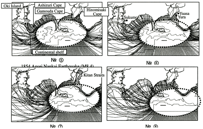
The next research is a case where the tsunami occurred east of where the 1854 Ansei Nankai earthquake tsunami occurred. Here we focus on No.(7) (Fig.3). In this case, since the tsunami source becomes closer to the inlet of the Kii channel than No.(5), the wave rays reach the Kitan straits located at the inner part of the Kii channel. It is thought that the difference between No.(5) and No.(7) is dependant on the influence of the tsunami source area and the sea bottom topography of the inlet of the Kii channel.
| (Enlarge: 93KB) |
 |
Figure 3. Spatial distributions of the wave rays (No.(5)-No.(8))
| (Enlarge: 100KB) |
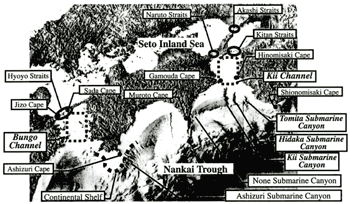 |
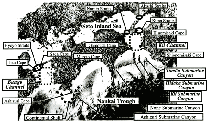
Figure 4. Sea bottom topography around Shikoku Island
Figure 4 shows the sea bottom topography around Shikoku Island. At the inlet of the Kii channel, there are three V-shaped submarine canyons. They are called, from west to east, Kii, Hidaka and Tomita. Moreover, these three submarine canyons are thought to affect the propagation of tsunamis into the Kii channel.
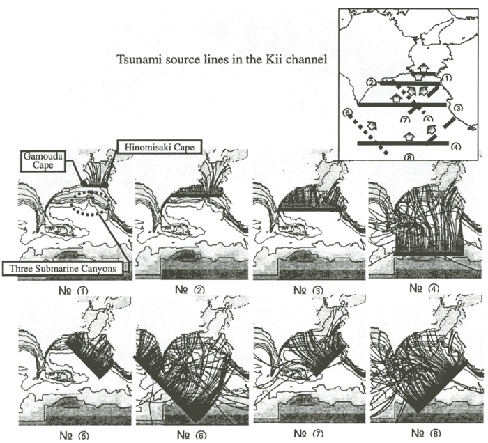
In order to verify the influence of submarine canyons, we studied the wave rays of tsunami supposing eight tsunami sources, which are changed, by the position related between three submarine canyons and the tsunami source (Fig.5). In the cases of lines (3) to (8) of which the tsunami sources are located to the south of the three submarine canyons, the wave rays will be bent towards the coasts south of Gamouda and Hinomisaki capes and therefore will not enter the Kii channel. On the other hand, in the cases of lines (1) and (2) of which the tsunami source is located to the north of the three submarine canyons, the wave rays enter the Kii channel. This shows the propagation characteristics of tsunamis on the coastal areas of the Kii channel will be affected greatly by whether the tsunami source is located to the north of the three submarine canyons or not.
| (Enlarge: 123KB) |
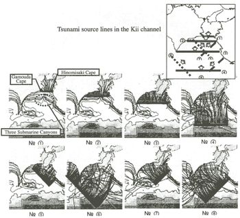 |
Figure 5. Wave propagation characteristics from tsunami sources in the Kii
channel
Propagation characteristics of a tsunami in the Bungo channel
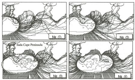
Our next research focused on the case in which a tsunami occurred on the southern side of where the 1854 Ansei Nankai earthquake occurred (Fig.6). Here we focus on the No.(2). In this case, the wave rays enter the Bungo channel easily and reach the Sada cape peninsula located in the inner part of the Bungo channel. This is because, unlike the Kii channel, the sea bottom topography doesn't change drastically and thus the tsunami propagates into the inner parts of the Bungo channel without being strongly refracted.
Figure 6. Spatial distributions of the wave rays (No.(1) - No.(4))
| (Enlarge: 112KB) |
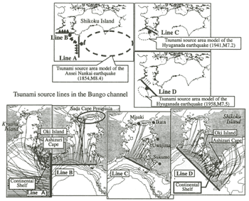 |
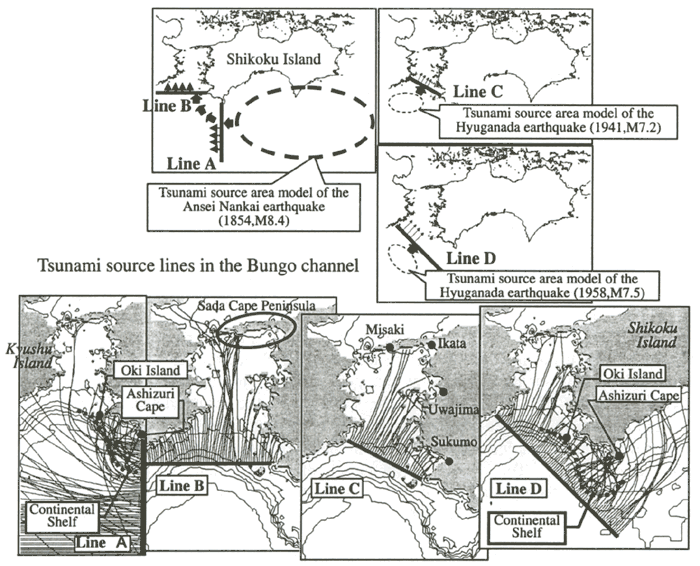
Figure 7. Wave propagation characteristics from tsunami sources in the Bungo
channel Just like in the case of the Kii channel, we installed four tsunami sources near the inlet of
the Bungo channel, in order to understand the relationship between the location of the tsunami source
and sea bottom topography (Fig.7). In this case, as the model for the tsunami source, we installed the
source of the Hyuganada earthquake tsunamis, which occurred in 1941 and 1958 as well as the Nankai earthquakes.
In the case of line A (Fig.7) where a tsunami goes west at first, we can see that the wave rays will bend towards the coast from Ashizuri cape to Oki Island influenced, by the continental shelf which extends from Ashizuri cape to Oki Island, and that it is difficult for it to enter the Bungo channel. In the case of line B in which tsunamis go north, tsunamis go straight on toward the Sada cape peninsula, therefore very little will reach the west coast of Shikoku island and the east coast of Kyushu island. Also, in the case of line C and D in which the tsunami will propagate north east like the 1941 and 1958 Hyuganada earthquake tsunami, the tsunami will propagate north east, straight to the west coast of Shikoku island and will propagate very little to the east coast of Kyushu island. We think that this is due to the drastic difference in the sea bottom topography between the Bungo and Kii channels. It should be noted that the wave rays did not reach the west coast of Shikoku Island or the east coast of Kyushu Island in the inner parts of the Bungo channel because the numerical simulation was stopped when the wave rays reached the many islands along the coast. In reality, a tsunami with a long wavelength will pass easily through the small islands and peninsulas and propagate deeper into the channel. This is the reason why there are records of damages by tsunamis in such places as Uwajima, Ikata and Misaki of Ehime Prefecture and Sukumo of Kochi Prefecture.
|