|
TSUNAMI PROPAGATION CHARACTERISTICS IN CHANNELS LEADING INTO THE SETO INLAND SEA
Kazuo Yoshida1, Tomio Shimada2, Hitoshi Murakami3, Yasunori Kozuki3 and Hiroshi Ichishima3
1 Coastal Engineering Division, River and Coastal Engineering Department, NEWJEC Inc.
Osaka, JAPAN
yoshidakz@osaka.newjec.co.jp
2Department of Construction Systems Engineering, Anan National College of Technology
Tokushima, JAPAN
3Department of Ecosystem Engineering, University of Tokushima
Tokushima, JAPAN
ABSTRACT
It is predicted that, in the near future, a big earthquake and subsequent tsunami may occur along the Nankai Trough off the coast of Shikoku Island in the south west of Japan. In this study, characteristics of tsunami propagation in the Kii and Bungo channels leading into the Seto Inland Sea are clarified in the first stage of investigating tsunami characteristics in the Seto Inland Sea. Consequently, it was shown that the propagation characteristics of a tsunami propagating into the Kii and Bungo channels is influenced by the relationship between locations of submarine canyons, a continental shelf and wave source, that both Kii and Bungo channels have a specific resonant period of 50 minutes, and 22-25 minutes, and that the tsunami heights in the Kii channel are easy to amplify irrespective of the period of incident waves.
INTRODUCTION
Shikoku Island is located in the southeast part of Japan and offshore of Shikoku Island to the Pacific Ocean side is the Nankai Trough. At the Nankai Trough, a huge earthquake and an accompanying tsunami is expected in the near future. This earthquake tsunami is called the Nankai earthquake tsunami.
The Japanese government has been seriously carrying out research and exploring countermeasures since 2001 for such a Nankai earthquake tsunami. The reasons for the Japanese government's moves are as follows. First is the fact that historically, Nankai earthquakes have occurred at intervals of 100 to 150 years. Second, is that the two most recent quakes occurred in 1944 and 1946 and since then fifty years has already passed. From those facts, it has been speculated that in the first half of this century, a huge earthquake and tsunami will occur. In addition, in October of 2001, the Japanese government estimated the probability of the Nankai earthquake occurring in the next thirty years to be 40%, in the next fifty years to be 80 percent. Also, stated that the magnitude of the earthquake will be around 8.4. From these movements, we must modify the countermeasures for the Nankai earthquake tsunami along the pacific coast of Japan.
Many researchers have investigated Nankai earthquake tsunamis. However, almost all the research has been on the pacific coast. Figure 1 shows the focus position of Nankai earthquakes, which occurred in the past and a map around Shikoku Island. A calm inland sea called the 'Setonaikai' exists between the Mainland and Shikoku Island. Although damage by tsunamis in the Seto inland sea have been reported in past research, the 1946 Showa Nankai earthquake tsunami did not cause much damage. Thus, the characteristics of a tsunami in Seto inland sea have not been researched in much detail. In order for a tsunami to advance into the Seto inland sea, it will have to go through the Kii and Bungo channels. Moreover, it will have to go through narrow straits called 'Kitan, Naruto and Hoyo straits'. Therefore, interest in tsunamis is very low in the coastal region of the Seto inland sea. Although it is hard for a tsunami to advance into the Seto inland sea, the water particle velocity and it's traveling distance will be large. As a result, there may be serious damage to cultivation rafts and berthing facilities for small ships.
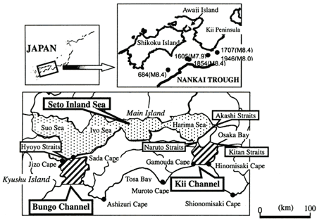 Figure 1. The focus position of the Nankai earthquakes, which occurred in
the past and a map around Shikoku Island
With, the above in mind, the main purpose of this study is to clarify the propagation characteristics of tsunamis, and the degree of risk of tsunamis in the Seto inland sea coast. For the first stage of this study, we carried out research on the tsunami's propagation characteristics in the Kii and Bungo channels located at the entrance of the Seto inland sea and the period response characteristics in both channels.
PROPAGATION CHARACTERISTICS OF A TSUNAMI IN THE KII AND BUNGO CHANNELS
Tsunami numerical simulation method
First, we carried out research on the propagation characteristics of tsunamis in the Kii and Bungo channels. For the numerical simulation of a tsunami, we analyze the wave rays by the wave. Front method and wave ray method from the tsunami source area. In addition, we calculate the space distribution of concentration and concentration emission of a tsunami. There's no guarantee that the next Nankai earthquake tsunami's source area will be the same as the source area of previous ones. In addition, characteristics of the tsunami will change with the scale of the earthquake, location of the fault plane and the tsunami source area. As shown in Figure 2, referring to the focus positions of the past Nankai earthquakes, we placed eight focus positions and the accompanying tsunami sources along the Nankai Trough and on each focus position tracked down the propagation characteristics of the tsunami into the two channels. Here, we looked at the Ansei Nankai earthquake tsunami, which occurred in 1854 and was the largest earthquake of the Nankai earthquakes. As the tsunami source area model for the 1854 Ansei Nankai earthquake tsunami, referring to past research, we adopted an ellipse of 126km in major axis and 70km in minor axis. No.(5) is the case of the 1854 Ansei Nankai earthquake tsunami.
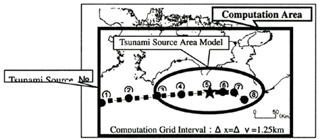 Figure 2. Location of the eight-tsunami source area models
Propagation characteristics of the tsunami of the 1854 Ansei Nankai earthquake tsunami scale
Figure 3 shows the distribution of wave rays
when moving the tsunami source area east from the 1854 Ansei Nankai earthquake tsunami source area. Wave
rays, which go to the Kii channel, are divided into the coast in Muroto cape to Gamouda cape, and the
coast in Shionomisaki cape to Hinomisaki cape. We can see that for this reason the energy of a tsunami
going into the Kii channel disperses and spreads. In the case of the Bungo channel, the western tip of
the tsunami source area does not reach the channel. Therefore, the wave rays are refracted and concentrated
along the coast from Ashizuri cape to Oki Island. From this, we can see that the energy of the tsunami
doesn't go into the Bungo channel easily. This is thought to be due to the effect of the continental shelf
which exists offshore of Ashizuri cape. However, when the wave rays are looked at carefully, it reaches
the coasts inside of the channels, such as Yura and Yuasa of Wakayama prefecture, which are located north
of Hinomisaki cape, and Shukumo in Kochi prefecture. As can be seen, it can be explained why these areas
were damaged by the 1854 Ansei Nankai earthquake tsunami from this method, too.
|