|
MODEL RESULTS
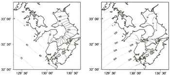
Tidal computation of the Ariake Sea
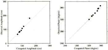
The model was integrated for 12 tidal periods (six days in M2 constituent). The model results are shown in Figure 3 from the final period. The amplitude and phase of the tidal elevation were calculated by the harmonic decomposition from the elevation results of each constituent case run. Figure 3 is the co-amplitude and the co-phase tidal chart of the M2 constituent. Tidal harmonic constants at nine stations (Sasebo, Nakura, Hukahori, Matugae, Aba, Akune, Kutinotu, Takezaki Sima and Yatsusiro) from the table of the tidal harmonic constant published by the Japan Coast Guard were compared with computed data (Table 1, Fig.4). The RMS (root mean square error) of the amplitude was 9.249 cm, and the RMS of phase is 3.838 degrees. The result of tidal computation shows the similar result with observed data, but the over-amplitude in inner bay of the Ariake Sea estimated. It seems that this model cannot estimate the variable tideland topography clearly.
| (Enlarge: 42KB) |
 |
Figure 3. The amplitude (in unit of cm) and the phase (in unit of degree
referred Greenwich) of the M2 tidal chart computed by the model
Table 1. Observed and computed tide data of M2 constituent
| Location |
Observed amplitude (cm) |
Observed phase (degree) |
Computed amplitude (cm) |
Computed phase (degree) |
| Sasebo |
85.0 |
340.043 |
84.592 |
341.255 |
| Nakura |
68.6 |
347.743 |
65.441 |
348.904 |
| Aba |
94.9 |
333.143 |
93.098 |
334.724 |
| Matugae |
83.5 |
328.943 |
84.417 |
331.579 |
| Hukahori |
83.8 |
329.543 |
83.525 |
330.939 |
| Takezaki Sima |
155.1 |
358.343 |
180.025 |
5.864 |
| Kutinotu |
101.4 |
350.143 |
107.680 |
356.000 |
| Yatsusiro |
112.4 |
351.843 |
122.112 |
357.085 |
| Akune |
79.7 |
320.243 |
80.406 |
320.224 |
|
| (Enlarge: 15KB) |
 |
Figure 4. The comparison chart between observed and computed M2 tidal constituent
| (Enlarge: 51KB) |
 |
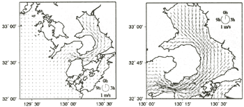
Figure 5. The computed tidal ellipses chart at the surface layer of M2 constituent
Figure 5 shows the surface tidal current of M2 constituent. The mouth of the Ariake Sea shows strong current, and the current of the inner Ariake Sea shows the strong currents at 3 hr and 9 hr (lunar time) and clockwise current pattern.
The mean current vectors averaged over one tidal period are shown in Figure
6. There are two strong mean current pattern; one is a northwestward current in inner Ariake Sea by anticyclonic
eddies on the onshore side, and the other is a southward flow near the eastern boundary. The southward
mean flow over the eastern coastline was recently suggested from the results of the drifter track observations
made in July 1992. Figure 7 shows the mean flow pattern inferred from this observation undertook by Ariake
Fishery Institute and Sanyo Techno Marin Inc. From Figure 7 we can see a northwestward flow in the offshore
region and a southward flow along the east coast. These features agree well with that in Figure 6. The
similar result is shown in the study of inner Ariake Bay ( Hukuda et al., 1994).
Figure 6. The depth-averaged residual current vectors
Figure 7. The surface mean current pattern inferred from the results of
drifter track observations made in July 1992. Cited from "A report on tidal analysis in Ariake Kai fishing
grounds" by Sanyo Techno Marine Inc. (1993)
|