|
INTERMITTENT UPWELLING IN THE WESTERN EQUATORIAL PACIFIC OCEAN REVEALED BY SEAWIFS
Katsutoshi Kozai1, Kunimitsu Ishida2, Takuhei Shiozaki3 and Yasuhiko Okada4
1Kobe University of Mercantile Marine
Kobe, JAPAN
kouzai@cc.kshosen.ac.Jp
2Toba National College of Maritime Technology, Toba, Mie, JAPAN
3Osaka Prefecture University, Sakai, Osaka, JAPAN
4Kinki University, Higashiosaka, Osaka, JAPAN
ABSTRACT
During the research cruise of R/V MIRAI (MR01-K05 Leg3) from November 9 to December 9, 2001, at the point of 2°N and 138°E in the western equatorial Pacific Ocean, SeaWiFS local area coverage (LAC) scenes are received by the station onboard R/V MIRAI while in situ atmospheric and oceanographic observations including the parameter of sea surface temperature, salinity, chlorophyll-a and current velocity profile to the depth of 300 m are carried out. The observed surface salinity and chlorophyll-a concentration increase from 34.1 to 34.37 and from 0.05 to 0.14 mg/m3 respectively while sea surface temperature decreases from 30 to 29.3 degrees after the week-long prevailing northwest monsoon wind with the maximum gust more than 20 m/s. The increase of chlorophyll-a in this region is also shown in the multi-date SeaWiFS chlorophyll-a concentration products. During the period of the week-long northwest monsoon wind the current velocity of upper 70 m reaches more than 60 cm/sec in the southeastward direction while the current velocity at the depth from 80 to 120 m indicates 50 cm/sec in the northwestward direction. The current of upper 70 m corresponds to the Northwest Monsoon Current (NMC) and the intrusion of NMC enhanced by the strong northwest monsoon winds (westerly wind bursts) causes a reversal in the sub-surface current (New Guinea Coastal Undercurrent (NGCUC)) which creates a temporal upwelling in this region.
INTRODUCTION
Equatorial upwelling in the Pacific Ocean is known to occur east of the date
line ( Wyrtki, 1981). However the estimates of equatorial upwelling in the
western equatorial Pacific Ocean is reported based on the moored current measurements ( Halpern
et al., 1989; Helber and Weisberg, 2001). Furthermore the presence of upwelling produced by the predominantly
easterly winds in the western equatorial Pacific Ocean is indicated ( Richards
and Pollard, 1991). Although the importance of monsoonal wind forcing on the surface circulation has
been discussed ( Lindstrom et al., 1987), the wind-induced upwelling in
the western equatorial Pacific Ocean is little observed because of its intermittent characteristics in
temporal and spatial scales. The purpose of this study is to not only describe the upwelling event observed
by SeaWiFS and in situ samplings during the research cruise of R/V MIRAI(MR01-K05 Leg3) but also investigate
the conditions of upwelling in temporal and spatial scales for contributing to better understanding of
air-sea interaction in the western equatorial Pacific Ocean.
DATA AND METHOD
Figure 1 shows the study area with the stationary observation at 2°N, 138°E
from November 9 to December 9, 2001. During this period the ship was moving around the stationary point
except the CTD (Conductivity-Temperature-Depth) profiler observations four times a day. Details of the
cruise log and summary of observations are listed in the R/V MIRAI Cruise Report (MR01-K05 Leg-314) ( JAMSTEC,
2001). Methods of in situ atmospheric and oceanographic observation including the parameter
of sea surface temperature, salinity, chlorophyll-a concentration and current velocity profile are summarized
as follows. The surface meteorological parameters such as wind speeds and directions are observed during
the cruise by the R/V MIRAI meteorological observation system. An anemometer is located at the foremast
24 m above sea surface and the 10-minute averaged true wind speeds and directions are recorded. Near-surface
water at the depth of 4.5 m is continuously pumped up at the rate of 200 liter per minute from the intake
to the sea surface-monitoring laboratory for measuring temperature and salinity. Surface seawater samples
are taken four times a day and the concentration of chlorophyll-a is determined onboard. CTD (Conductivity-Temperature-Depth)
profiler observations are carried out four times a day to the depth of 500 meters. Salinity is calculated
from the observed pressure, conductivity and temperature. The specifications of CTD are listed in Table
1. Current velocity profiles are measured by the shipboard Acoustic Doppler Current Profiler (ADCP) from
November 9 to December 9, 2001. The zonal (east-west) and meridional (north-south) velocity components
of 40 depth cells are observed every five minutes. Major parameters for the measurement configuration
of ADCP are listed in Table 2.
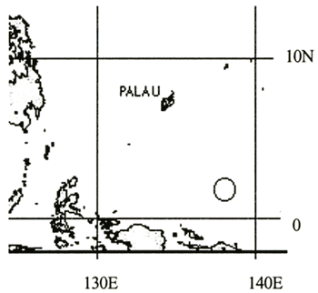 Figure 1. Study area with the stationary observation at 2N, 138E from November
9 - December 9, 2001 (Circle represents the stationary observation area)
Table 1. Specifications of CTD (Conductivity - Temperature -Depth)profiler
| Underwater unit |
CTD 9plus (Sea-bird Electronics, Inc.) |
| Temperature |
Range:-5 to +35℃, Accuracy: 0.001℃ |
| Conductivity |
Range: 0 - 7 S/m, Accuracy: 0.0003 S/m |
| Pressure |
Range: Up to 10500m, Accuracy: 0.015% |
|
SeaWiFS is an abbreviation of Sea-viewing Wide Field-of-view Sensor onboard the SeaStar launched in 1998. The sensor has eight bands in the visible and near infrared wavelengths and the tilt mechanism to avoid sun glitter as shown in Table 3.
Table 2. Measurement configuration of shipboard ADCP
| Frequency |
75kHz |
| Average |
every 300 sec |
| Depth cell length |
1600cm |
| Number of depth cells |
40 |
| First depth cell position |
30.9m |
| Last depth cell position |
654.9m |
| Ping per ADCP raw data |
32 |
|
Table3. Specification of SeaWiFS
| Band No. |
Center wavelength (nm) |
| 1〜8 |
412, 443, 490, 510, 555, 670, 765, 865 |
| Equator Crossing |
Local Noon (±20min), descending |
| Orbit type |
Sun Synchronous at 705km |
| Spatial resolution |
1.13km(LAC), 4.5km(GAC) |
| Swath width |
2801km(LAC), 1502km(GAC) |
| Scan Plane Tilt |
+20°, 0°,-20° |
|
During the research cruise from November 14 to December 10 SeaWiFS LAC (Local Area Coverage) scenes are received by the station onboard R/V MIRAI once a day under the authorization of NASA SeaWiFS project as the temporary real-time agreement. All SeaWiFS raw data are decrypted by using the OGP software provided by NASA GSFC. Higher-level products such as chlorophyll-a concentration are generated by using SeaDAS software.
RESULTS AND DISCUSSIONS
Throughout the period of research cruise there are two typical weather conditions.
One is characterized by the strong northwest monsoon winds (or westerly wind bursts) during the periods
from November 18-24 and from December 1-9. The westerly wind burst is one of the characteristic wind variability
in the tropics with a period of 40-50 days (Madden-Julian Oscillation, (Madden and Julian, 1971,
1972)). The other is characterized by the strong insolation with weak
monsoon winds during the periods from November 12-17 and from November 25-30. Since the SeaWiFS LAC scenes
acquired during the former periods show the high cloud coverage, the SeaWiFS LAC scenes available for
analysis are limited to those acquired during the latter periods. From now on the observation period is
divided into three periods, namely the period of (November 18-24), before (November 12-17) and after the
strong northwest monsoon winds (or westerly wind bursts) (November 25-30).
Period before the strong northwest monsoon winds (from November 12-17)
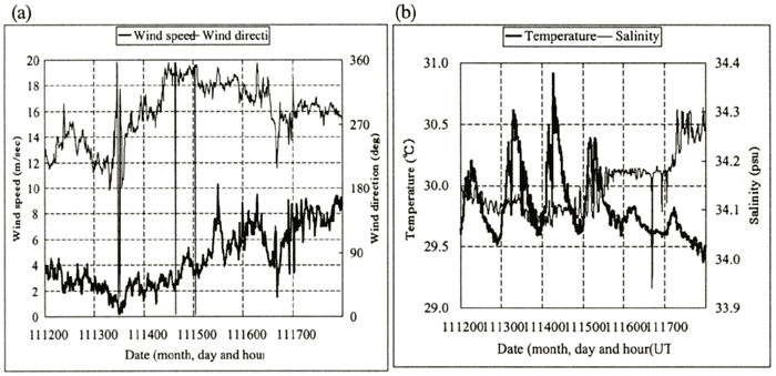
Figures 2(a)-(e) show the temporal variability of wind speeds and directions, sea surface temperature and salinity at the depth of 4.5 meters, temperature and salinity overlaid with velocity vectors, temperature-salinity diagram with depth respectively. Wind speeds are ranging from 0 to 10 m/sec and the wind directions are mostly northwest. One of the typical features in the upper ocean can be seen in the sea surface temperature changes of 1.5℃ during the local daytime of November 13 and 14, which are caused by the strong isolation with weak monsoon winds.
| (Enlarge: 47KB) |
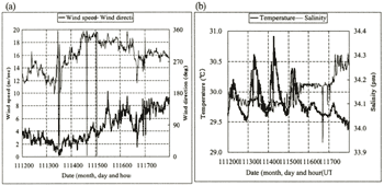 |
Figure 2. Temporal variability of wind speeds and directions (a) and the
one of sea surface temperature and salinity (b) from November 12 - 17
A sharp decrease of salinity in November 16 may be attributable to 3 mm/h precipitation
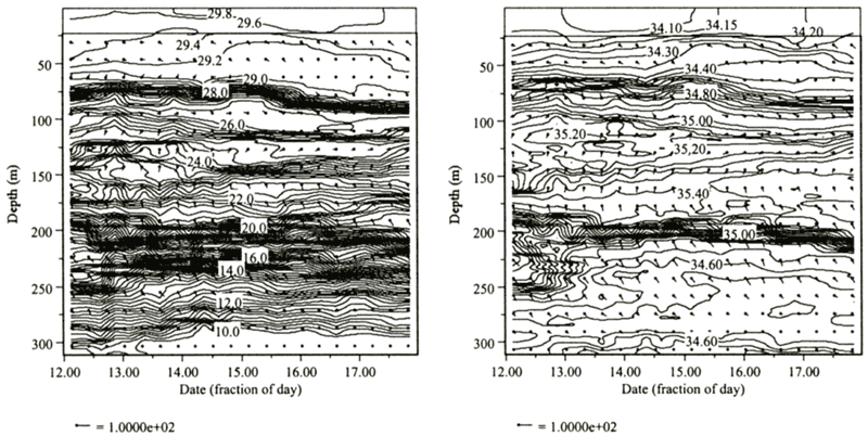
observed by the shipboard rain gauge. As far as the temporal variability of temperature and salinity overlaid
with ADCP data is concerned, three distinctive layered current structures are shown in Figures 2(c) and
(d). The first one from the surface to the depth of 50 m corresponds to the Northwest Monsoon Current
(NMC) ( Masuzawa, 1968) which can be characterized by the weak flow (less
than 30 cm/sec) toward southeast directions. The temperature and salinity are ranging from 29.2 to 29.8℃
and from 34.1 to 34.4 psu respectively. The second one from the depth of 80 m to 120 m corresponds to
the New Guinea Coastal Undercurrent (NGCUC) ( Lindstrom et al., 1987).
Although the NGCUC is originally defined as the sub-surface equatorward velocity maximum centered at the
depth of 200 m adjacent to the coast at 2°S, it is indicated that the Northwest Monsoon Current overlies
the northwestward flow of the NGCUC ( Fine et al., 1994). The temperature and
salinity are ranging from 25 to 29℃ and from 34.6 to 35.2 psu respectively. The third one from the depth
of 200 m to 250 m corresponds to the Equatorial Undercurrent (EUC) which can be characterized by the strong
southeastward flow reaching about 70 cm/sec. The temperature and salinity are ranging from 13 to 20℃ and
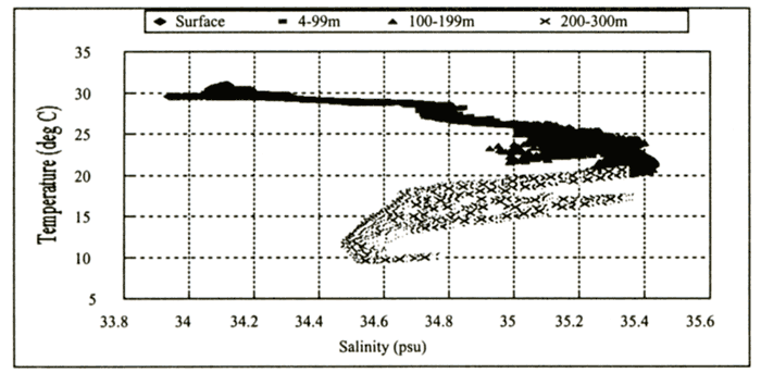
from 34.6 to 35.2 psu respectively. Figure 2(e) shows the temperature-salinity diagram with four different
depth ranges. The salinity maximum of 35.45 with the temperature of 22℃ can be seen at the depth range
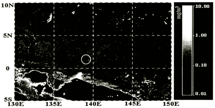
of 100-199 m which is located between the NGCUC and the EUC. Figure 3 shows the SeaWiFS-derived chlorophyll-a
concentration composite during this period. Around the stationary observation point (2N, 138E) the concentration
is below 0.1mg/m 3. On the other hand high concentration areas are found in the
northwest of the stationary point (3N, 135E) and the northern coast of New Guinea Island.
| (Enlarge: 91KB) |
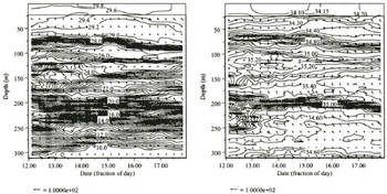 |
Figure 2. Temporal variability of temperature (c) and salinity (d) overlaid
with velocity vectors from Nov. 12 to 17 (Units of temperature, salinity and velocity are degree Celsius,
psu and cm/sec respectively.)
| (Enlarge: 34KB) |
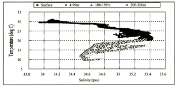 |
Figure 2(e). Temperature-Salinity diagram with depth from November 12-17
| (Enlarge: 38KB) |
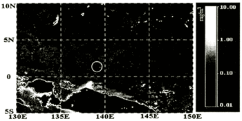 |
Figure 3. Chlorophyll-a concentration composite derived from SeaWiFS data.
(November 12-17) (Circle represents the stationary observation area indicating low chlorophyll-a concentration
below 0.1 mg/m3 (before the wind-induced upwelling))
|