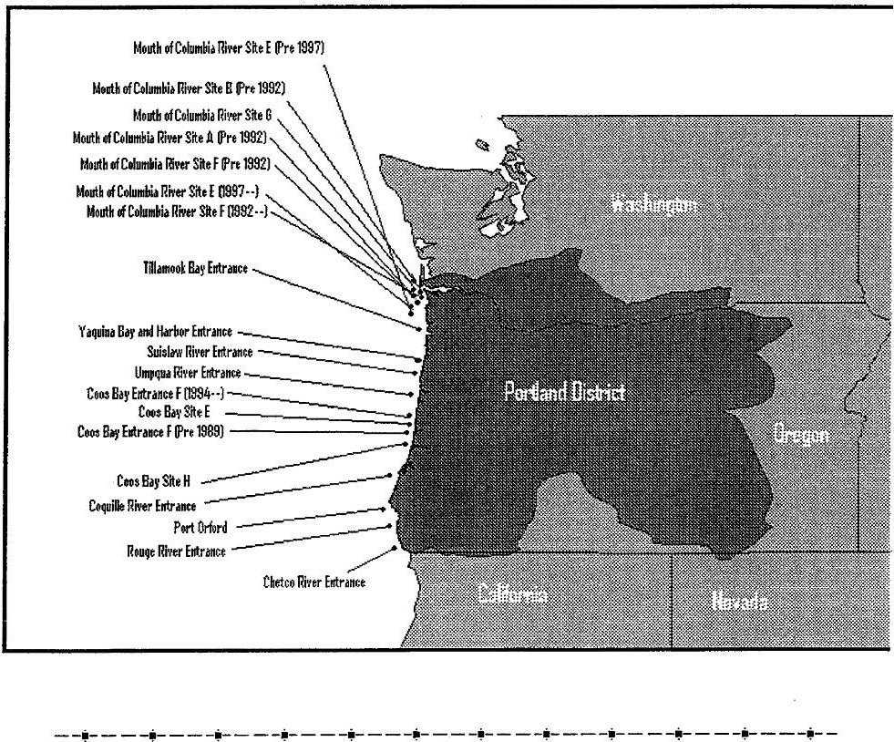
Ocean Disposal Database
Home/ Division Map
Click on a disposal site name to view information on that disposal site or clickhere to view a list of disposal sites for the Portland District.
{The Mouth of Columbia River Site E (1997--) and Coos Bay Entrance F (1994--) disposal sites have bathymetry data available.}
(拡大画面: 251 KB)
地域別の地図2(ポートランド地域の図面。点で表示されているのが個々の投棄地点。地点名称をダブルクリックすると各地点の情報が得られる。)
Ocean Disposal Database
Disposal Site
Home/District Map/Epa Map
View all projects disposed of at This Site / Historical use of this site/ Past disposal dates
Last project that disposed at this site
Project Name: CHETCO
Permittee:
Beginning date of this project; 6/22/99
The total quantity disposed from this project in cubic yards: 39,813
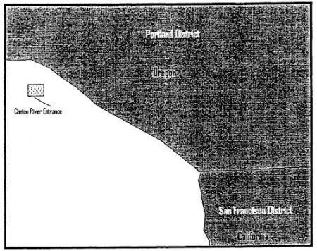
個別投棄地点情報1:地点概要(ポートランド地域、Chetco River Entranceの例)
Disposal Site Information
Disposal Site Name: CHETCO RIVER ENTRANCE
District Name: PORTLAND CE District: NWP State: OR
Database Site Number: 21 EPA Region: 10 Geographical Region the site is in: Pacific
Designation Status: Final Designation Date:
Designation Sources July 1996
Diameter of site, if circle (in feet) : O
Are the coordinates the geographical center of this site? N
| Latitude (Center): ゜'00.0" |
Longitude (Center): ゜'00.0" |
| Latitude (First Corner): 42゜01'55.0" |
Longitude (First Corner): 124 16'37.0" |
| Latitude (Second Corner): 42゜01'55.0" |
Longitude (Second Corner): 124 16'13.0" |
| Latitude (Third Corner): 42゜01'37.0" |
Longitude (Third Corner): 124 16'13.0" |
| Latitude (Fourth Corner): 42゜01'37.0" |
Longitude (Fourth Corner): 124 16'37.0" |
| Latitude (Fifth Corner): ゜'00.0" |
Longitude (Fifth Corner): ゜'00.0" |
North American Datum (NAD) of latitude/longitudes 1983
Size of the disposal site (in square nautical miles):0.09
Distance from nearest point of land (in nm) : 0.9
Site Depth (in feet) : Shallowest =68.9 Deepest =72
General information on the site: Restrictions: Disposal shall be limited to dredged material determined to be suitable for unconfirmed disposal from the Chetco Estuary and River and adjacent areas.
Ocean Disposal Database
Amount of Dredged Materials Ocean Disposed By Year in Cubic Yards at the Disposal Site
home Choose a Disposal Site
Site Name: CHETCO RIVER ENTRANCE Total Quantity
| Year |
TotalQuantity |
| 1976 |
60,100 |
| 1977 |
7,800 |
| 1978 |
56,000 |
| 1979 |
44,200 |
| 1980 |
54,300 |
| 1981 |
76,300 |
| 1982 |
65,100 |
| 1983 |
61,000 |
| 1984 |
31,900 |
| 1985 |
35,000 |
| 1986 |
40,300 |
| 1987 |
15,200 |
| 1988 |
33,700 |
| 1989 |
20,000 |
| 1990 |
36,800 |
| 1991 |
31,500 |
| 1993 |
35,300 |
| 1994 |
18,800 |
| 1995 |
29,800 |
| 1997 |
36,600 |
| 1998 |
38,500 |
| 1999 |
39,813 |
個別投棄地点情報2:年別投棄量(ポートランド地 域、Chetco River Entrance の例)
Ocean Disposal Database
Past Disposal Dates
Home
Disposal Site:CHETCO RIVER ENTRANCE
| Beginning Date |
Project Name |
| 6/22/99 |
CHETCO |
| 6/6/98 |
CHETCO RIVER ENTRANCE |
| 6/3/97 |
CHETCO |
| 5/29/95 |
CHETCO |
| 6/30/94 |
CHETCO |
| 6/30/93 |
CHETCO RIVER |
| 5/25/91 |
CHETCO |
| 4/30/90 |
CHETCO |
| 7/31/89 |
CHETCO |
| 6/1/88 |
PORTLAND DISTRICT, CHETCO RIVER, OREGON |
| 5/9/87 |
PORTLAND DISTRICT, US ARMY CORPS OF ENGINEERS |
| 5/7/86 |
US ARMY CORPS OF ENGINEERS |
| 5/15/85 |
PORTLAND DISTRICT, CORPS OF ENGINEERS |
| 5/20/84 |
PORTLAND DISTRICT, CORPS OF ENGINEERS |
| 5/3/83 |
CHETCO RIVER |
| 4/8/82 |
CHETCO RIVER |
| 4/15/81 |
CHETCO RIVER |
| 4/1/80 |
CHETCO RIVER |
| 4/20/79 |
CHETCO RIVER |
| 4/8/78 |
CHETCO RIVER |
| 8/30/77 |
CHETCO RIVER |
| 4/13/76 |
CHETCO RIVER |
| |
|
| Beginning Date |
Permittee Name |
| No permitted projects were disposed of at this site. |
|
個別投棄地点情報3:開始時期順の投棄事業一覧(ポー トランド地域、Chetco River Entrance の例)
Ocean Disposal Database
Project
Home Select Project
Year:1990
Project name:CHETCO
Chemistry data exists for this project
CE district - NWP This is a Federal Project [DS=1514]
Permit Dates: Start: Expiration
Location of Dredging Project CHETCO RIVER, OR
State: OR EPA Region:10
Quantity Disposed - Cubic Yards: 36,800 Cubic Meters: 28,137
Method used to dredge the material: Hopper Dredge
Method used to transport the material: Hopper Dredge
Method used to discharge the material: Hopper Dredge
Frequency of dumping: 15/D;7D/W Beginning date: 4/30/90 Ending date: 7/10/90
Disposal Site Information:
Primary disposal site: CHETCO RIVER ENTRANCE Disposal Site number: 21
The disposal site has the following coordinates:
| Latitude (Center): ゜'00.0" |
Longitude (Center): ゜'00.0" |
| Latitude (First Corner): 42゜01'55.0" |
Longitude (First Corner): 124 16'37.0" |
| Latitude (Second Corner): 42゜01'55.0" |
Longitude (Second Corner): 124 16'13.0" |
| Latitude (Third Corner): 42゜01'37.0" |
Longitude (Third Corner): 124 16'13.0" |
| Latitude (Fourth Corner): 42゜01'37.0" |
Longitude (Fourth Corner): 124 16'37.0" |
| Latitude (Fifth Corner): ゜'00.0" |
Longitude (Fifth Corner): ゜'00.0" |
North American Datum (NAD) of latitude/longitude 1983
Distance from nearest point of land (in nm) : 0.9
Size of the disposal site (in square nautical miles) : 0.09
Site Depth (in feet) : Shallowest = 68.9 Deepest = 72
Reference Site Information:
No Reference Site Information Available
Disposal Site Management - Seasonal Restriction
Disposal Site Monitoring - The following monitoring was performed (date last done - frequency):
Bathymetric monitoring: - YEARLY
chemical monitoring: None -
Physical monitoring: None -
Biological monitoring: None -
Organisms Used in Elutriate Bioassay Testing
Organisms Used in Solid Phase Bioassay Testing
Organisms Used in Bioaccumulation Bioassay Testing
General Comments:
Point of Contact: MARK SIIPOLA Phone Number: 503-326-6463
Chemistry data exists for this project
個別事業の例1(ポートランド地域、Chetco River EntranceにおけるChetco事業の例。1990年4月 30日投棄開始事業)