2) Road Side Interview Survey;
3) Screen Line, Cordon and Site Specific Traffic Count Survey;
4) Travel Time Survey;
5) Traffic Generation Survey for Key Traffic Generating Land Use;
6) Public Transport Market Research; and
7) Parking Survey.
(2) Study Process
An outline and approach adopted in each of these phases and the activities undertaken are described briefly.
1) Phase 1: Project Inception
2) Phase 2: Diagnostic
3) Phase 3: Project Proposal Development
4) Extension and Refinement
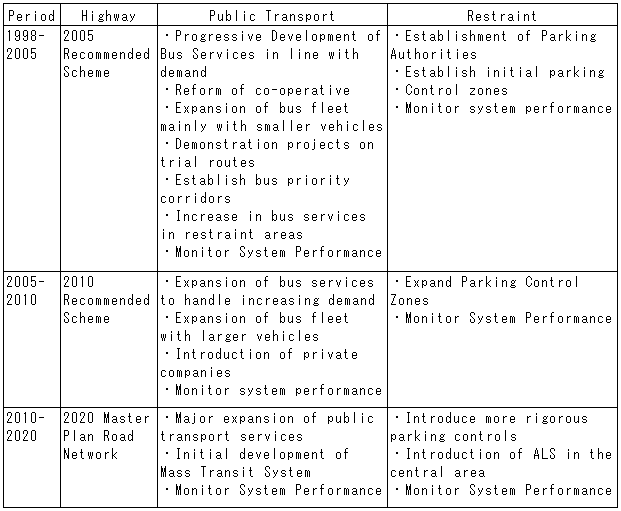
4.5 The recommended transport system for HCMC
The main components of the long-term transport strategy, the Master Plan Road Network for 2020, are (1)The Master Plan Road Network, (2) Support for the movement of freight vehicles, (3) Improved road based public transport, (4) Increased restraint on private transport users, (5) Consideration of the development of rail based mass transit system, and (6) Development of a transport database and monitoring.
The 2020 Master Plan Road Network would provide a highway network in HCMC which comprises a series of ring roads around the urban core and existing developed urban areas. These routes would provided a high level of accessibility in the inner urban and suburban areas, and would support the economic development of the areas away from the city center and would provide a focus for new industrial and distribution activities offering a high level of accessibility.
There will be socio-economic and environmental impacts from the construction of program. However, many of the environment effects are either small or can be mitigated. Given the likely extent of development and change within HCMC within the next 20 to 25 years, the socio-economic impacts are probably manageable within the context of the likely land use development of the city.