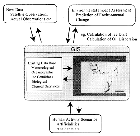
Figure 4.6.5 Schematic diagram of environmental impact prediction and assessment in the use of the GIS
丂
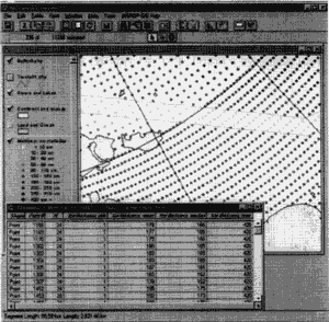
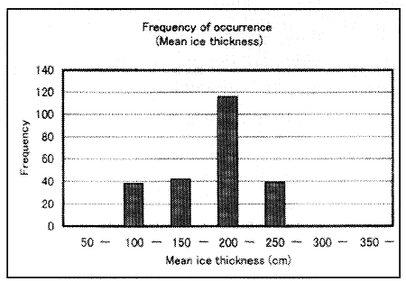
Figure 4.6-3 shows an enlarged view of the western part of the East Siberian Sea. The line of dots in the map shows the points at which data were obtained. When an assumed route with a certain band width is plotted, the data at the points inside the route-band are indicated. In the diagram, the assumed route is indicated in red lines. The data points inside the route-band appear as yellow dots, and a table within the diagram shows a list of the data on the assumed route. Using one of the functions of the GIS software, simple statistical processing can be performed on these data. Figure 4.6-4 shows a histogram illustrating the frequency distribution of ice thickness on the route. In addition to the data processing by the basic GIS software, ordinary statistical analyses can be also carried out by preparation of scripts registered in the menu as the occasion demands.
Although simple data processing such as the examples above can be performed on ISNROP GIS software, for more complex calculations, such as numerical forecasting, the GIS must be linked to external software applications. Because the GIS is a database software, its interface was designed to accommodate such external processing. Many application software can work with the GIS through a dynamic link function. The GIS can also input and output data to and from many major file formats, such as text, Excel and dBase files, so that data can be shared even without dynamic link function. Figure 4.6-5 shows a schematic diagram of one possible use of these features, in which the GIS is used as a database and viewer in a system for forecasting and evaluating environmental changes. This illustration shows the potential for the GIS in future environmental impact assessment systems and as a basic technology in sustainable, environment-friendly development. Moreover, INSROP GIS can be linked with other GIS systems to exchange information for a wide variety of uses, such as policy proposals at the national and regional level, planning of the activities of various agencies, and exchange of opinions and decision-making on specific scenarios. Such linkage will also enable researchers to revise, update and supplement data as well as expand the program's functions, on a constant or regular basis.