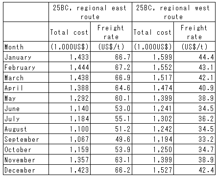
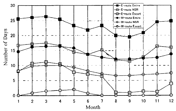
The regional west route links Dikson with Hamburg over a distance of 4,020 nautical miles. Its eastern counterpart runs from Tiksi to Yokohama over a distance of 2,397 nautical miles. The former route traverses the NSR only through the Kara Sea, while the latter winds through the Laptev Sea, East Siberian Sea and Chukchi Sea. Because each of these routes runs almost exclusively through shallow coastal waters of the southerly route as described earlier, the simulation for these routes was conducted only for the 25BC with a shallow draft, and the characteristics of each of the regional route operations were clarified. MSV was adopted as the simulation method, so ice data from 1957 to 1990 were applied, and average monthly values over 30 years were used to calculate monthly changes in number of voyage-days, sea speed and operational costs (Figure 4.4-11, Table 4.4-9). On the eastern route, the number of icebreaker escort days was a relatively long 0.9-11.2 days, indicating the harshness of the ice conditions in the eastern NSR. Because the regional west route crosses only the Kara Sea, the ice conditions on this route are much more moderate, reducing the number of icebreaker escort days to 0.7-2 days; in years of favorable ice conditions, passage with no icebreaker support at all is even possible. In the easier ice conditions, ship speeds are faster in the regional west route. Sea speeds only fall down into the 4-6 knots range from February to May; during the rest of the year, the speeds of around 10 knots are possible. Table 4.4-9 shows the freight rates by month, defined by the ratio of total cost per voyage to transported cargo volume. The total cost per voyage was found in the range of US$704,000-898,000 for the regional east route and $457,000-656,000 for the regional west route. For details on sea speeds and operational costs for each route, please see Appendix 5-2.
丂
Table 4.4-9 Total cost per voyage and freight rate by month (regional routes)
丂
Figure 4.4-11 Average number of voyage-days by month on the regional east and west routes and their breakdowns (average values through 1957-1990)
丂
Annual operational costs for the seasonal NSR operation
In the winter season, the simulation showed that freight costs tend to be lower on the Suez Canal route than in the NSR. From the practical standpoint, the subject of inquiry was then addressed for possible alternative operations of the NSR or the traditional route, asking how much freight costs could be reduced by switching between the Suez Canal route and the NSR in response to the ice conditions. The study focused on the northerly route, and the vessels used were the 40BC and 50BC. This scenario well reflects the economic realities: even when the NSR is commercialized, for the foreseeable future it will have to be used in alternation with the Suez Canal route. Key indexes should therefore be found for decision-making of route selection. As one of the key indexes, the cumulative ice index was chosen in this study, which indicated the level of difficulty of navigation in the NSR.