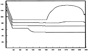
Figure 3:丂Time-depth plot of interface position (left) and temperature (right). The horizontal axis gives the integration time in days. The vertical axis is the z coordinate in meters. Contour interval for temperature (in 亷) is 0.5亱.
丂
While the density field is uniform, there is actual vertical shear in the solution. After 180 days, the ocean heats, but wind stress prevents restratification until the production of turbulent kinetic energy by the wind is suppressed by the net buoyancy forcing. Heating of layer 1 and 2 is evident after day 220. At day 270 the heating rate is maximum. As predicted by Monin-Obukhov theory, we find that the mixed layer is shallowest at that time, while the maximum temperature in the mixed layer occurs later at day 320.
丂
INDIAN OCEAN MODEL
丂
As earlier mentioned, TOMS is a generalized version of the hydrodynamical Indian Ocean Model by Jensen (1991). It was demonstrated that a high resolution (1/5亱), 3.5 layer model produced very realistic currents for the upper ocean.
The new Indian Ocean model model has 5 layers with the bottom topography confined to the deepest layer. The initial thickness is 80m, 120m, 250m, 600m for layers 1-4, while the thickness of the deepest layer varies from 150m to 3000m, with a mean of 2500m. The potential densities (冃兤cra) of the five layers are 23.6, 25.4, 26.5, 27.2 and 28.2 respectively. The horizontal resolution is 1/8亱. The model grid has 714 亊 446 grid points in each layer for each variable. In order to gain computational speed, the method of gravity wave retardation (GWR method) was applied with a GWR factor of 1/256 (see Jensen, 1996 for details). This allows a time step of 320 seconds. The code runs in parallel on the IPRC SGI Origin 2000, with up to 666 Mflops on 16 CPUs.
The model is spun up from rest using monthly mean wind stress from the European Center for Medium Range Weather Forecast (ECMWF) reanalysis and was integrated for 5 years. Figure 4丂shows the flow in layer 5 in the central Indian Ocean. Jensen (1993) found strong semi-annual oscillations along the equator in the upper ocean. As seen in Fig 4 these oscillations are also present in the deep ocean, but the steep bottom topography modify the flow locally, and the phase relation to the upper layer flows are not simple.
Very high horizontal resolution enables the model to resolve currents in jets along the coast. Figure 5 demonstrates the ability to resolve the inertial flow past the island of Madagascar as the South Equatorial Current feeds the East African Coastal Current. Notice the back eddy flows as well as the offshore mushroom shaped eddy-pair. The model fully resolves the coastal boundary currents, so that the maximum boundary current speed is found offshore. In this simulation, the jet north of Madagascar is highly variable in position and eddy shedding occurs every few months. Higher resolution does not only improve on the numerical accuracy, but more importantly allows for adequate resolution of islands, straits and boundary flow phenomena.