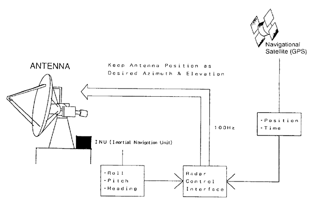
One of the most important factors to be considered in using Doppler radar aboard is how to stabilize the radar antenna against ship movement. In the present system, we adopt an inertial navigation unit (INU) mounted on the antenna pedestal. An INU collects the information of the pitch, roll and heading of the pedestal as well as their time derivatives at a high frequency. A Global Positioning System (GPS) receiver is also used to provide radar position (latitude, longitude) and time. From these INU and GPS data the radar system control the antenna to be fixed to a horizontal plane on the earth surface(Fig.1). This method is as same as the previous trial to use Doppler radar on the vessel during TOGA-COARE(Toropical Ocean and Global Atmosphere - Coupled Ocean and Atmosphere Response Experiment) intensive observation (Rutledge et al. 1993).
Fig.1 Schematic diagram of antenna stabilization
Objectives
The shipboard Doppler radar will be mainly used for the better understanding of the precipitaion mechanism of the convections which develop over the warm water pool. Previous studies have suggested the relation among the eastward moving intraseasonal oscillations(ISOs), the ENSO phenomena, and Indian Monsoon. It is also known that ISO (O (10000km, 30-60 days)) is composed of several eastward moving super cloud clusters(SCCs,O(1000km,lweek), Nakazawa 1988). SCCs are also composed of cloud clusters(CCs, O(100km,1-2 days)). Since the present radar can measure in the range of 200km for the precipitaionand 100km for the wind, it may be able to cover not only individual clouds but also some of whole cloud clusters above mentioned.