However, recently, the drifting buoy data have been progressivly accumulated by efforts of the drifter community (e.g., Niiler et al., 1987) and archived at the MEDS. This dataset covers broader regions with finer resolution than before, permitting us to describe the global surface circulation in more detail. In doing so we closely examine not only the mean field of the circulation but its seasonal one.
Finally, based on the fact that the buoy-derived velocity can give the absolute SSH field described above, a simultaneous assimilation model of drifting buoy and altimetric data is proposed to better determine the mean SSH as well as the temporal evolution of the surface circulation on synoptic scales.
2 Data and Methodology
The drifting buoy data used in this study are provided mainly by the MEDS and partly by the Japan Oceanographic Data Center (JODC). Originally, this dataset consists of 2409 buoys, part of which has a very short lifetime (less than 1 day). After the reduction of these buoys, the remaining 1864-buoy data, which are comprised mostly by drifting buoys with an exception of several mooring buoys, are used here
Under the same assumption for the buoy-position erorrs as in the previous studies (e.g., Piola et al., 1987), the time series of the position data are processed to compute velocities along the trajectory of each buoy: all of the trajectories are smoothed using a cubic spline function to avoid the amplification of computational errors for the calculaton of velocities induced by the noise of the position data (Patterson, 1985) and the hourly buoy positions are determined by interpolation. After then, very high frequency fluctuations like the inertial oscillation and tidal motion. which are out of scope in this study, are removed. The resulting trajectories allow us to compute the hourly velocity along each trajectory using the centered difference scheme. From these hourly velocities, we have constructed two kinds of the climatological velocity datasets; the "monthly dataset" for the annual and monthly mean velocity field (without consideration of interannual variabilities) and the "time-series dataset" (not described here) for the eddy field.
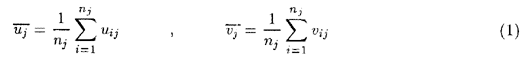
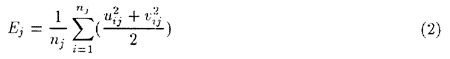
Following Patterson (1985), the velocities of zonal and meridional components u and v averaged over 1 month in time and a 2° square in space can be obtained as
where uij(vij) is the zonal (meridional) component of the i-th velocity observation (hourly velocity) during the j-th month, nj is the number of velocity observations in each grid in the j-th month during the study period. Averaging over 2° squares is adopted to secure the velocity map with finer resolution and concurrently with as much statistical reliance as possible. In doing so, the data are removed when the departure from the monthly average in each is beyond twice the standard deviation in each grid.
Figure 1 shows the spatial distribution of the total number of the hourly velocity data in each grid throughout the study period, in which areas of no data appear in the North Indian, around northern Australia and Antarctica in addition to the tropical Atlantic. However, in several regions such as the North Atlantic, the equatorial and the northwestern Pacific and The Agulhas retroflection region, the number of the data is large enough to make a dataset with finer (1° × 1°) grids.