|
HOTS (HIGHWAY ON THE SEA), A NEW APPROACH TO LOW-VISIBILITY NAVIGATION
Ove Bjorneseth Aalesund University College Norway
Abstract: Enhancing bridge-crews situational awareness has become recognized as a critical element in reducing accidents involving high-speed crafts (HSC). In the aviation industry improved display concepts have been investigated for several decades as a mean of enhancing awareness of position, flight path, and terrain. Little or no effort has been done in investigating use of enhanced/synthetic vision as a tool of improving safety in navigation and situational awareness onboard HSC's, nor in development of such systems.
As a part of the R&D effort in HCS navigation, a new navigational display for low-visibility navigation was developed and tested in the "state-of-the-art" HSC simulator at Aalesund University College (AUC). The display called the HOTS (Highway On The Sea) is based on the theory that the distance between information sources, in terms of visual angle, can lead to serious cost of scanning (especially when going from head up to head down and vice versa) which in turn will result in a loss of situational awareness. The HOTS display is a radical and new approach in electronic navigation instrumentation for use in HSC's where instrument symbology is superimposed on the out-the-window scene (like HUD's used in airplanes). The goal is to minimize the scanning distances between information domains and thereby enhance situational awareness. It is expected that in the future HUD like interfaces also will be introduced in ship navigation.
The HOTS display was created using a human-centered design and evaluation approach, and in an effort to minimize attentional issues, "scene-linked" symbology was introduced.
1. INTRODUCTION
Driving and navigating high-speed crafts (HSC) is a complex task, especially in bad weather where the crew has to rely only on instrument navigation. Compared to air traffic this type of navigation could be regarded as a continuous landing phase in poor visibility.
Under low-visibility conditions, navigators can easily become spatially disoriented, leading to time-consuming interactions with instruments. Navigators must interpret data form a myriad of instruments that each provide only one piece of information. These pieces must be integrated into a mental model of the ownship state with respect to position, destination, terrain, and other ship; this is often referred to as situational awareness.
Worldwide hundreds of accidents and incidents have occurred because the navigators have not been able to maintain accurate situational awareness.
Many of the factors involved are insignificant in their own right, but when combined with other nominal insignificant factors they can result in a chain of events whereby navigators involved become overloaded and confused as to what is happening (loss of situational awareness) and thereafter begin to carry out inappropriate actions for the situation ahead.
How much of this lack of situational awareness can be directly related to the ability of the human resources to collect information and construct mental models is unknown, but it is clear that poor ship systems and bridge design is often a significant casual factor to why bridge-crews become confused and begin to mishandle the situation they find themselves in.
As of today there are no regulations into force on how to select HSC personnel. The reason for this is that the STCW 95 was issued before the HSC code (effective 1 . January 1996) and therefore does not define the peculiar characteristics that the HSC operators must have. Consequently, the ability to operate and the relevant certification are delegated to the Authorities of each Member State. On the contrary to the aviation field, all the qualifications and training programs for the HCS operators does not make reference to any procedure or regulations in Europe nor in the World.
1.1 Statistics on HCS related accidents
The inshore coast of Norway is one of the most difficult areas to navigate in the world. Thousands of small islands, shallows and narrow straits must be passed, very often during extreme weather conditions and also in 24-hour winter darkness [6].
Consequences of navigation error are almost as serious as for air pilots, and accidents statistics of HCS's are not pleasant reading. During the period from 1981 to end 2001 there were reported a total of 105 accidents with NOR-NIS registered vessels under the category of Passenger skips/ferrys; Catamarans/trimarans/hydrofoils. 65 of the accidents were related to navigational errors, vessel handling, and faulty or wrong use of operational routines.
Further 25 of the accidents are registered as breakdowns or technical errors mainly in the steering or engine systems. In the same period there were reported a total of 22 casualties of which 19 were passengers and 3 crewmembers. 16 of these casualties were alone accounted for in one single accident.
The respective inspectors of the accidents concludes that 80% of all reported accidents related to operation of HCS's are related to human errors, of which 70% are caused by misjudgment, lack of attention, presumption or lack of competence in navigation.(Source: Dama)
Two recent HSC accidents (1991,1999) with fatalities in Norwegian waters underscore the pressing need for action on this issue. The first serious accidents in Norway occurred on 4. November 1991 when the HSC SeaCat run aground. Two lives were lost in the accident, and many were severe injured. The second accident occurred on 26. November 1999 when HSC Sleipner run aground at Store Bloksen rocks. 69 persons were picked up alive, 15 were found dead and one person is still missing.
Both accidents occurred while navigating at high speed during dark winter season, and both accidents have been thoroughly investigated, and extensive reports have been written (NOU 200:31, NOU 1994:9). The reports in both cases conclude that the accidents were related to human errors. In the HSC SeaCat-accident the grounding was due to a missed navigational light, and in the HSC Sleipner-accident the vessel run aground due to navigational errors during high waves and low-visibility conditions. Both accidents clearly shows that even though the vessels were equipped with state of the art instrumentation an navigational aids, the navigators did not know the exact position related to it surroundings in the minutes before the accidents.
This statistical material shows that most of the accidents where HSC's are involved are especially tragic since it involves variables over which the operators should have control. HSC safety is best served by having competent, well trained navigators operating the vessels. But still the difficulty remains in making sure that the navigators understand the information provided by available instruments such as radar, ECDLS, GPS, and navigational lights and markings, and from this be able to decide how they are positioned and oriented in the surroundings.
2. MOTIVATIONS
The persistence of human error related fatalities provide the motivation to investigate and develop improved instruments for use in HSC's navigation in shallow waters. The fact that most HCS accidents occurs in low-visibility conditions shows that the instrumentation in common use today are not adequate or too time-consuming to operate taking into account the speed HCS's operate under.
Extensive literature search has resulted in little or no findings of research related to new methods or instruments to improve low-visibility operations onboard a HCS. Nor has searches resulted in findings of use of HUD or synthetic vision displays as navigation aid in HSC navigation. However, a vast amount of recent research on use of HUD and synthetic vision display can be found in the domain of aircraft [1], [2], [7], (8], [9], [11]. This gave the idea to try to utilize some of this research and to adopted the Tunnel-in-the-Sky concept to a Highway On The Sea (HOTS) concept. The concept of a Tunnel-in-the-Sky, which is the most prominent idea in synthetic vision displays in aircrafts, originated with George Hover and the Army Navy Instrumentation Program in the 1950s. Thereby synthetic vision systems for aircraft have been the subject of discussion and research for more than 50 years.
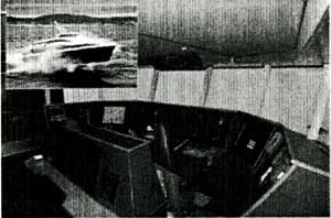
After the "SeaCat-accident" Aalesund University College (AUC) started to focus on the need for better training of crews and better design of HSC bridges. In 1998 the planning of a full-mission HSC bridge simulator for advanced training and R&D was started. After a 4-year project study the realization phase started, and the simulator was ready for initial testing in early 2003. The general arrangement of the cockpit is based on the most used HSC type in Norway which complies with the IMO HSC-code. This is the FlyingCat consept, designed and developed by the Ejellstrand Yard (Fig. 1). Very few (if any) simulators in the world can match the capabilities of the HSC simulator at AUC [6].
The synthetic vision research related to navigation of HSC's at Aalesund University College (AUC) has been focused on the design, implementation and simulator testing of a new display for navigation of HSC's that hopefully will improve navigator performance. A human-centered design and evaluation approach has been used in the development of the instrument.
Fig.1 HSC-simulator at AUC
2. DISPLAY CONTENT
The underlying idea in designing the HOTS display system is to utilize an analogy to conventional automobile highways. The display system presents symbology on a combiner glass so that information appears to be projected over the view of the world beyond the cockpit. The HOTS system uses computer-generated scene-linked symbols [3] overlaid upon the sea surface to provide route guidance and navigation information. The general idea behind the system is to augment visual cues that are degraded in low-visibility and provide information that the navigator normally utilizes during clear-visibility conditions.
Research shows that fixed-location HUD symbology appears to lead to attentional tunneling, which reduces the pilot's ability to maintain awareness of instrument information and information in the far visual scene [4]. With the conventional head-down configuration, the eye and head movements necessary to scan back and forth between the panel display and the far visual scene may disrupt attentional tunneling so joint awareness is improved [10], [5].
However studies conducted by NASA have showed that scene-linked symbology can eliminate attentional tunneling. Scene-linked HUD symbols are drawn, and move, as virtual objects in the out-the-window scene, and appear to be physically part of the world [3]. As the HSC moves through the world, the scene-linked symbols that are projected onto the display undergoes the same visual transformations as real objects. There are no differential motion cues to cause the visual system to interpret the virtual symbols as separate from the world. In absence of these cues, attentional tunneling should be prevented, enhancing the ability to process scene-linked HUD symbology in parallel with real-world information.
In contrast to traditional fixed-location, superimposed HUD symbology, scene-linked symbology can take multiple forms [4]. Generally scene-linked symbology can be grouped in three groups.
・Scene-Enhancements - the graphic outline of existing objects in the external world, such as a 3D terrain, "virtual navigational lights", or virtual target ships that may be obsolete due to low-visibility.
・Scene-Augmentation - the addition of virtual, three-dimensional objects that is otherwise non-existent in the real world, such as graphic overlay on the sea surface to give the impression of a road, virtual warning signs etc.
・Virtual Instruments - the depiction of ownship instrumentation and data on "virtual billboards" that appear to the side of the aim-point (projecting virtual instrument gauges in the world)
The HOTS display system incorporates all three groups of scene-linked symbology. Scene-enhancements is used when the 3D augmented terrain, virtual navigation lights, or other navigation marking is activated. Scene-augmentation is the most prominent use of scene-linked symbology in the instrument. Scene-augmentation is mainly used to give the navigator the important route information. Virtual instruments are used in form of positional information, heading, speed, roll, pitch, yaw, and informational billboards.
Advanced display solutions are only useful insofar as the technology is available to implement them. The ability to generate cost-effective complex and computing intensive displays like the HOTS is now possible through COTS hardware. But still displays using scene-linked symbology require an advanced display medium, such as a HUD, an accurate terrain database, and a highly accurate positioning system.
|