|
2.2 Database Development.
The reconnaissance trip for Port Jersey was undertaken April 30 and May 1, 2002. The purpose of the reconnaissance trip was to observe navigation conditions in Port Jersey and collect pictures and video for both Port Jersey and Arthur Kill. The photographs were used to update the simulation visual scene.
Computer Science Cooperation (CSC) had previously developed the visual scene for New York Harbor. for the U. S. Army Engineer Transportation School in Fort Eustis, VA. CSC updated the visuals based upon data collected during the reconnaissance trip and information about the future Port Jersey provided by NAN. Container cranes were added on the southern side of the port near the turning basin and NEAT was replaced by a container facility.
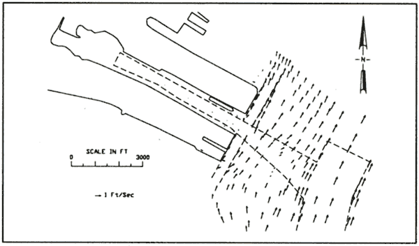
Currents for the proposed 50 ft channel were calculated at ERDC during a previous TABS-MD study (Mc. Van, in preparation). Simulations were conducted for maximum ebb and flood tidal currents. The flood currents used to develop the simulation models are shown in Figure 5. Wind conditions were chosen to act in the same direction as the currents. Wind gusted around 25 knots for all scenarios.
The channel and bank databases were developed at ERDC prior to the real-time simulation testing. SeaNav developed the Electronic Chart Display and Information System (ECDIS) for the proposed conditions. The U.S. Coast Guard (USCG), First District provided locations of aids-to-navigation (ATONS) for the proposed conditions.
Designers & Planners, Inc developed the simulation model of the Susan Maersk under contract for a 2001 study of Bergen Point.
4000 horsepower (HIP) tugs were available for the pilot's use. An ERDC employee in the control room controlled the assist tugs. The pilot used a radio to request tug actions.
Figure 5. Flood currents for Port Jersey
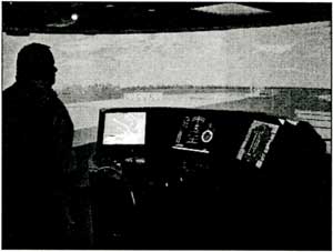
The two new ERDC Ship/Tow Simulators have been operational since February 2002. The simulators are CSC Virtual Ship 2000 models. The simulators are "real time" i.e. ship movements on the simulator require the same amount of time as in real life. Environmental forces such as currents, wind, banks, ship-ship interactions all act upon the vessel during a transit. The pilot cons the simulated vessel's engine speed and rudder. The pilot also has radio contact with assist tugs. The Susan Maersk has bow and stern thrusters that are pilot controlled. The two simulators can be coupled together for two-way traffic, but were run independently for the one-way Port Jersey simulations. Figure 6 shows the ERDC simulator being operated during validation of the Port Jersey study. The pilot in Figure 6 positioned himself on the port wing for a better view down the ship's side, as he would do in real life.
Typically, pilots operate the simulator from the bow view. However, for Port Jersey many of the runs required backing the ship. The pilots can rotate the simulator view as desired. Most of the pilots rotated the view 90 degrees to the right. That way both bow and stern are visible on the right and left sides of the screen, respectively. Some of the pilots used this view when backing into or out of the Port Jersey.
Figure 6. NY Pilot on wing of Susan Maersk
2.3 Simulation Program
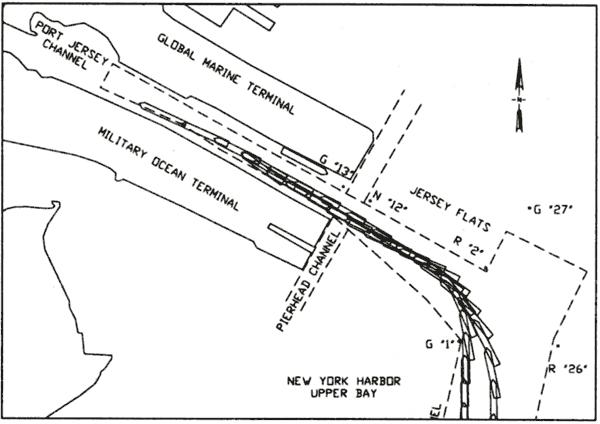
Simulations exercises were conducted for both inbound and outbound ships. The inbound ships either pulled bow-in to Port Jersey, or turned in the Jersey Flats and backed in Port Jersey. The outbound runs either pulled straight bow-out of Port Jersey, or backed out of Port Jersey and turned in the Jersey Flats. Figure 7 shows the track plot of two inbound ebb tide, bow-in exercises. Although the ebb tide pushed the ships south while turning. All vessels successfully turned into the port.
Figure 7. Track plot inbound ebb tide. bow-in
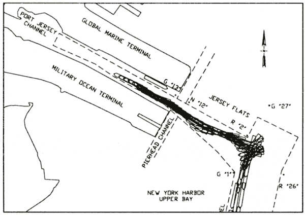
Figure 8 contains the track plots of the Susan Maersk backing out of Port Jersey and turning in the Jersey Flats during ebb tide. Despite the sudden set to the south caused by the ebb currents the straightened channel provided enough room to back out and turn the ship.
Figure 8. Track plot outbound ebb tide, bow-in
A detailed description of all simulator results for Port Jersey is beyond the scope of this paper. Full results are included in the projects technical report (Webb, in preparation).
2.4 Port Jersey Recommendations
The Susan Maersk, at a draft of 46 ft. is significantly larger than containerships presently using Port Jersey. The proposed realigned channel is essential to allow the Susan Maersk to call at Port Jersey once the channel is deepened to -50 ft mlw. Presently, if tug used, the assistance of two tugs is required. It is possible that three tugs may be necessary for some maneuvers. Moving buoy G"1" from it's present position to the channel corner as simulated for some of the pilots appeared to give the pilots a better feel for their ship's location.
It is recommended that the Port Jersey Channel be realigned as proposed.
It is the responsibility of the USCG to mark navigation channels. It is recommended that their NY District office be provided with a copy of this report so they evaluate the position of ATONS for the realigned Port Jersey Channel.
|