|
A SUMMARY REPORT ON SIMULATOR STUDIES OF NEW YORK HARBOR DEEPENING
Dennis Webb (ACOE-ERDC, USA)
Frank Santangelo (ACOE-New York District, USA)
Abstract: The US Army Corps of Engineers,
New York District, in conjunction with their local sponsor, the Port Authority
of New York and New Jersey (PANYNJ), has recently completed a feasibility study
for New York and New Jersey Harbor, which recommended deepening channels of the
Port of New York and New Jersey to-50 ft mlw. Channels included in the studies
were Ambrose, Anchorage, Port Jersey, Arthur Kill, Kill Van Kull and Newark Bay
Channels. The design vessel for the proposed channels was the Maersk S-class containership.
Some of the deepened channels, such as Port Jersey and the Arthur Kill will require
realigning. Evaluation of the proposed channels was conducted during a navigation
study that included real-time ship simulation. Currents for the proposed harbor
condition were modeled by US Army Corps of Engineers - Engineer Research and Development
Center (ERDC) with a TABS-MD model. TABS-MD is a finite element model and is used
to provide currents for most ERDC simulator studies. Construction of portions
of the deepened channel will require blasting of bed material prior to dredging.
The Arthur Kill channel is a narrow, constricted waterway. In order to reduce
the times the dredge must move out of the way of commercial traffic, the proposed
dredge positions were modeled during a simulator study to determine if or when
the dredge would have to be moved. The simulations were conducted by the ERDC,
at their facility in Vicksburg, MS. Both docking masters and state pilots participated
in the simulations. This paper will describe the reasons for the proposed NY Harbor
improvements, the areas modeled during the simulator study, and the study's results.
1. INTRODUCTION
New York Harbor waterways are extensively used navigation channels for both commercial and recreational vessels within the Port of New York and New Jersey. The Corps of Engineers presently maintains about 240 miles of navigation channels within the port, Figure 1. The U. S. Army Engineer District, New York (CENAN) is evaluating improvements to several areas of the harbor, including the Arthur Kill and Port Jersey Channels. The Arthur Kill is presently maintained to -35 ft mlw. The Port Authority recently constructed a channel at Port Jersey to -38 ft mlw. However, both channels are scheduled to be dredged to -41 ft mlw during 2003. Different classes of vessels share these waterways. The larger vessels are Panamax containerships calling at both Global Marine Terminal in Port Jersey and the Howland Hook Terminals on the Arthur Kill Channels and large tankers bringing their product to Tosco Refinery.
The proposed improvements to NY Harbor include deepening the navigation channels to -50 ft mlw and realigning specific areas. The improvements are designed to accommodate the S-class containerships, such as the Susan Maersk. These containerships are 1140 ft long with a beam of 140 ft. The "S" class containership and is capable of drafting 47-1/2 ft.
Figure 1. New York Harbor.
Construction of the Arthur Kill Channel (-41 ft mlw to Howland Hook, -40 ft mlw to Tosco) will require blasting of the rock channel bottom. This will necessitate buoying off sections of the channel and declaring them non-navigable while the rock is being removed, affecting the operations for ships passing through these areas. CENAN requires an evaluation of operation impacts for various dredging scenarios.
To assist CENAN in their evaluations of the proposed 50-ft project and construction alternatives for the 41-ft project, the ERDC conducted ship-simulator based navigation studies in 2002.
2. PORT JERSEY
2.1 Project Description.
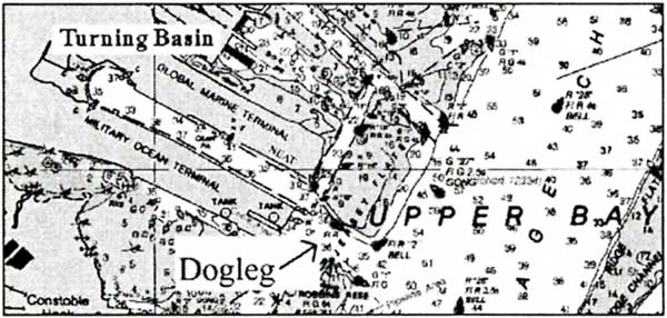
Port Jersey is located on the western side of the Upper Bay of New York Harbor in the City of Bayonne, NJ, as shown in Figure 2. The channel is slightly over one mile in length is terminated with a 1200 ft turning basin. Port Jersey presently services the North East Auto Terminal (NEAT) on it's eastern corner, the Global Marine Terminal (GMT) container terminal on the north side near the existing turning basin, and the currently inactive Military Ocean Terminal) on it's southern side. The Port Jersey channel is presently -38 ft mlw. Ships transiting between the Port Jersey Channel and the Anchorage Channel must negotiate a dogleg that prevents the ship from lining up to enter the channel prior to entering.
Figure 2. Port Jersey
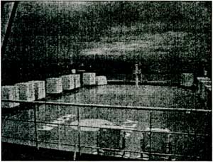
Once the 50 ft project is constructed, new container cranes will be installed on the port's northeast corner and on the south side near the turning basin. At a length of 1140 ft, the Susan Maersk is too long to use the existing 1200 ft diameter turning basin. Therefore, the ship will have to either be backed into or out of Port Jersey. However, the Susan Maersk is also too long to back through the dogleg at the entrance to Port Jersey. The difficulty encountered by ships approaching Port Jersey is illustrated by a photo (Figure 3) taken from the bridge of a car carrier calling at NEAT. The ship is obviously near the entrance to Port Jersey and well south of that entrance.
Figure 3. Car Carrier Approaching Port Jersey
CENAN proposes two improvements to the Port Jersey. The first improvement is to remove the dogleg and straighten the approach to Port Jersey. The proposed approach to Port Jersey is shown in Figure 4. The new channel will be 1600 ft where it joins the Anchorage Channel. The second improvement is to widen the inner channel within the protected portion of Port Jersey. NAN proposes to construct a 500 ft wide channel between the northern and southern berthing areas to -50 ft mlw. In addition to the channel, 150 ft wide berthing areas will also be deepened to -50 ft mlw.
Figure 4. Proposed improvements
|