|
How the CNIS works
Dover CNIS is a Coastal Vessel Traffic Information
Service (VTIS) mainly concerned with traffic passing through the area to ensure
that essential information becomes available in time for on-board navigational
decision making by the mariner.
The information service provides broadcasts at fixed
times and intervals, when deemed necessary by the VTIS or at the request of a
vessel.
CNIS broadcasts on VHF radio channel 11 every 60 minutes
(every 30 minutes if visibility drops below two miles) to give warnings of navigational
difficulties, weather conditions and traffic information in the TSS. This includes
misplaced or defective navigational aids, hampered vessels, deep draught bulk
carriers and tankers, vessels under tow, surveying vessels and unorthodox crossings
such as cross channel swims. A broadcast is also transmitted for any vessel that
appears to be in contravention of the COLREGS, to warn other vessels that a potentially
hazardous situation exists in a particular part of the TSS.
Ships using the TSS are automatically tracked by radar
and evidence collected, which can be used on possible prosecutions of alleged
contraventions of the COLREGS. If the alleged offending vessel is bound for a
UK port then action may be taken but otherwise the evidence is forwarded to the
Flag State for them to investigate and take action under the International Rules.
In the case of UK registered vessels, all information
is forwarded to the MCA Enforcement Unit to investigate.
The Mandatory Reporting Scheme, in accordance with
Safety of Life at Sea (SOLAS) convention 1974, regulation 8-1, Chapter V, was
introduced in the Dover Strait TSS in July 1999, whereby all vessels over 300
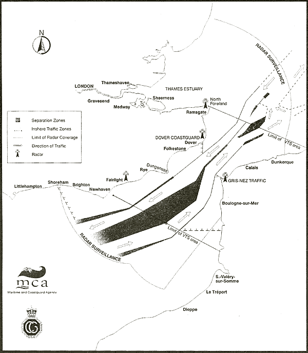
gross tonnage are required to participate. The service area covers a 65 mile stretch
of the Dover Strait/Pas-de-Calais and is bounded by a line to the east drawn from
North Foreland to the border between France and Belgium; and by a line to the
west drawn from the Royal Sovereign Light Tower, through the Bassurelle Light
Buoy (at its assigned position) to the coast of France.
Included in the 65 mile area the Traffic Lanes and
the Inshore Traffic Zones (ITZ).
The Traffic Lanes are to be used for NE and SW bound
vessels and have been developed and adopted by IMO in order to provide the safest
possible navigational assistance to the mariner. This takes into account the deepest
water - there is a section of the NE Lane which is specifically designated a Deep
Water Route (DWR) - and underwater hazards such as sand banks and obstructions,
i.e. wrecks.
ITZs are designated areas along both the UK and French
coasts, the UK ITZ is bounded by a line drawn from Shoreham to the CS1 Light Buoy
(marking the termination of the SW Lane) and a line drawn South from South Foreland
to the SW Lane. This area has restrictions; a vessel shall not use an ITZ when
she can safely use the appropriate traffic lane within the adjacent TSS. However,
vessels of less than 20 metres in length, sailing vessels and vessels engaged
in fishing may use the zone.
In addition, a vessel may use an ITZ when en route
to or from a port, offshore installation or structure, pilot station or any other
place situated within the ITZ or to avoid immediate danger.
This does not preclude the master of a vessel using
the ITZ if he/she considers it necessary for the safety of the vessel and its
crew providing the CNIS is advised of the intended route and reasons for the passage.
The Mandatory requirement from ships entering the
area covered by the system is the Pas de Calais/Dover Strait Report; the short
title for the ship report is CALDOVREP.
The report should contain the following information:
・Name of the ship, callsign, IMO identification number and MMSI number.
・Position expressed in latitude and longitude.
・Course and speed of the ship.
・Vessel's draught.
・Route information.
・Hazardous cargo, IMO class and quantity (if applicable).
・Breakdown, damage and/or deficiencies affecting the structure, cargo or equipment of the ship or any other circumstances affecting normal navigation in accordance with the provisions of the SOLAS and MARPOL Conventions.
Vessels on passage NE should report to CROSS Gris
Nez traffic, on the French Coast, two nautical miles before crossing the boundary
line in the NE Traffic Lane. Vessels on passage SW should report to Dover Coastguard
on the English Coast when within VHF radio range of North Foreland, and not later
than when crossing the boundary line in the SW Traffic Lane. The majority of reports
are received via VHF radio; however AIS transponder reports can be received by
Dover Coastguard. Radio and telephone traffic and from Coastguard co-ordinator
centres is recorded for the purposes of public safety, preventing and detecting
crime and to maintain the operational standards of HM Coastguard.
Who is exempt?
There are exemptions from the CALDOVREP scheme.
Cross Channel ferries are not required to participate
in full, as the freight cargo can, and does, cover a vast amount of different
categories and to expect a full manifest via VHF radio would be unreasonable.
Therefore, ferries on a regular scheduled short sea crossing only have to advise
Dover Coastguard or CROSS Gris Nez that they have departed. Ferry companies hold
the manifest which is available at immediate notice should this be necessary following
an incident with a ferry. Cross Channel ferry movements, whether freight or passenger,
have reached more than 100 per day, with the main Dover-Calais route being by
far the busiest with four main operators. The other route taking freight and passengers
is Ramsgate to Ostend.
Naval vessels irrespective of nationality are also
exempt from reporting this is due to the very nature of their role. However the
vast majority comply with the reporting scheme, mainly to advise the CNIS that
they are on passage. No other details are requested.
There are approximately 500 shipping movements, SW,
NE and crossing, per 24 hour period, which include the following:
Merchant vessels from all corners of the globe, carrying every category of cargo imaginable, from iron ore to wheat, and crude oil to sugar.
Fishing vessels are from Channel Ports in the main,
such as Belgium, France, UK and Holland, although other nationalities ply their
trade on occasion.
Other movements include a considerable number of pleasure
craft such as yachts primarily in summer. These are combined with other marine
associated pleasure craft such as jet skis and cruisers.
There are a number of vessels with engine defects
each year, most classified as minor problems rectification is quick and the vessel
continues on its intended passage without involvement of CNIS. Others are more
serious and can take some days to resolve. These situations can develop without
notice and require a vessel to anchor or drift not under command possibly in a
traffic lane of the TSS or near to the coast. In order to prevent a collision
or hazardous situation and protect the environment an Emergency Towing Vessel
(ETV) has bean chartered to patrol the TSS and will be called upon to guard or
assist the vessel that has suffered an engine problem. It will also warn other
vessel of the situation.
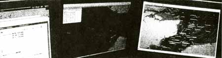
The Dover CNIS system has been refurbished and has
introduced the latest radar and Vessel Tracking System technology combined with
data fusion from other sensors.
Traffic Separation Scheme
The Maritime and Coastguard Agency
MCA Dover, Langdon Battery, Swingate, Dover CT15 5NA
T +44 (0) 1304 210008 F +44 (0) 1304 202137 channel_navigation@mcga.gov.uk
The Maritime and Coastguard Agency is an Executive Agency
of the UK Department for Transport
|