|
魅惑される景色
絵画にみる南島の自然
岩陰(いわかげ)に岩壁画をのこした古代の「モア・ハンター」から、現代のCGアーティストまで、いつの時代も南島の自然はあらゆる芸術家たちにインスピレーションを与えてきました。
最初に南島の絵を描いたのは1773年にニュージーランドを探検したジェームズ・クックでした。ウィリアム・ホッジス(画家)は樹木に覆われ、野生的魅力のあふれる海岸沿いの山地を描きました。彼は、マオリの家族を題材にした優れた作品でも知られています。
19世紀になると・ルイ・ル・ブルトン(フランス人、画家)が、オタゴ湾、オタコウの捕鯨集落の人々を画題にとりいれます。その後、内陸を調査のため調査官が派遣されますが、多くが地図以外に、スケッチをのこしています。これらのスケッチは、貴重な南島の景観の記録となっています。
20世紀にはいると・コリン・マカホン、リタ・アンガス、ロビン・ホワイト、マリリン・ウェブ・グレアム・シドニーなどが南島の自然地形について不朽の作品をのこしています。
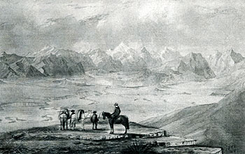
「グランドビュー山からの眺望」1857. ジョン T. トマソン
John Hall-Jones collection
Inspiring Landscapes
Southern art down the ages
The natural character of Southern New Zealand has inspired artists of all kinds, from the moa-hunters who left images in limestone shelters to the computer graphic artists of today.
James Cook's 1773 exploration of New Zealand produced the first painted images of Southern New Zealand. Dusky Sound, Fiordland, was the focus; William Hodges the artist. Hodges depicted a mountainous land by the sea, forested and invitingly wild. He painted a Maori family in splendid isolation.
In the next century, French artist Louis Le Breton also featured people in the foreground of his paintings of the Otakou whaling settlement in Otago Harbour. Then came the surveyors, who ventured inland. Many could paint as well as produce survey maps - notably John Turnbull Thomson, John Buchanan and Charles Kettle. Field sketches by explorers such as James Hector and Government agent Walter Mantell helped record southern landscapes. Architectural draughtsman George O'Brien came to Dunedin from Melbourne, documenting settlement and land use in his paintings. A contemporary, William Mathew Hodgkins, chose mostly wilder settings, especially around the Wakatipu and Wanaka regions.
In the 20th century, landscape art blossomed. Colin McCahon, Rita Angus, Robin White, Marilynn Webb and Grahame Sydney are among the many painters who have left enduring images of southern landforms.
「大陸」の海を漂う島々
| (拡大画面:501KB) |
 |
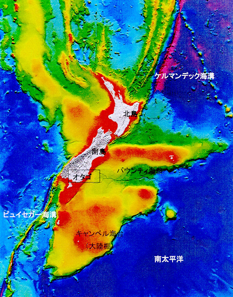
ニュージーランド周辺の海底地形図(courtesy of NWA)
ニュージーランドは、南太平洋西側の海底に没した「ミニ大陸」から海上に顔を出した部分ということもできます。
本島の南から南東にかけての海底には、キャンベル海台(かいだい)のような、比較的浅く大陸棚(だな)が広がっています。ニュージーランド近海にある5つの群島のうち、亜南極圏に接する2つ(スネア諸島、バウンティ諸島)は花崗岩からできた古代大陸の頂上部にあたります。他の3つ(オークランド島、キャンベル諸島、アンティポーズ諸島)は、火山活動によってできた島々で、亜南極圏の2つに比べると、ずっと新しいものです。
オタゴの東側には巨大な海底峡谷、バウンティ海盆(うみぼん)があります。これは陸上の川と同じく、支流が集まる大きな谷が形作られています。バウンティ海盆は南島よりも大きく、東側に900km以上のびています。
大陸棚はフィヨルドランドの海岸沿いで最も狭くなり、フィヨルドの端からわずか数キロのところで、急に深くなり海溝(かいこう)となります。北島の北東に伸びるこの海溝は太平洋プレートとオーストラリアプレートの衝突によって生まれたものです。
バウンティ海盆
1960年代の海図では、長さ1,000kmのバウンティ海盆は世界で最も長く、大きな海溝のひとつであるとされています。オタゴ沖の海底に連なる狭い谷は、バウンティ海盆にのびる「支流」のひとつとなり、その幅は最大2kmほどにもなります。何百万年もの間、海流はこの「支流」をつうじて土砂をはこび、バウンティ海盆の出口にあたる太平洋の海底に扇状地をつくりあげています。
Undersea New Zealand
Islands adrift in 'continental' waters
New Zealand is riding on a submerged 'mini-continent', far out to sea in the Southwest Pacific.
To the south and southeast of the mainland are vast areas of relatively shallow continental crust - the Campbell Plateau and Bounty Platform. Two of the five New Zealand subantarctic island groups (The Snares and Bounty Islands) are the crests of an ancient granite landmass. The other three groups (Auckland, Campbell and Antipodes Islands) are volcanic and much younger.
East of Otago is an enormous submarine valley, the Bounty Trough, which resembles a major river system on land, fed by substantial tributaries. Larger than the South Island, the Bounty Trough extends eastwards for over 900 km. To the north of the Bounty Trough is the Chatham Rise, an arm of continental shelf connecting the Chatham Islands to the mainland.
The continental shelf is narrowest along the Fiordland coast, where the ocean deepens quickly just a few kilometres from the outer edge of the fiords. Here, the Puysegur Trench picks up the line of the Alpine Fault after it leaves the land. This trench and the Kermadec Trench to the northeast of the North Island mark abysses created by the collision of the Pacific Plate and Australian Plate.
The Bounty Trough
Charted in the 1960's, the 1000 km-long Bounty Trough is one of the world's longest and largest deep-ocean conduits. A series of narrow canyons off the Otago coast feeds into channels that lead to the main stem, the Bounty Channel, which is up to two kilometres wide. For millions of years, currents have transported sediments through this system, building a fan where the Bounty Trough opens onto the floor of the Pacific Ocean.
世代をこえ、うけつがれる宝
ポウナム(ヒスイ)は富と権威の源とされていました。ポウナムは、すばらしい武器、道具、装飾品に彫刻された。「パツ・ポウナム」または「メレ・ポウナム」(どちらもこん棒)は、美しく仕上げられたトキ(手斧)と同じく、マオリ会社における地位の高さをあらわす象徴でした。これらのポウナムは、一つ一つに名前が付けられ家宝として代々受け継がれ、儀式などに登場しました。
ポウナムで作った装飾品やお守りには、目をうばわれるすばらしさをもつ「ヘイ・ティキ(人のイメージを形にしたもの)」や「ヘイ・マタウ(釣り針形)」などのペンダントや、気品のある耳飾りなどがあります。特に「ヘイ・ティキ」は多様に変化する緑色と、光沢により価値の高いものでした。
おそらくどの芸術形態よりもポウナム・タオカ(ポウナム製の品)は、熱帯ポリネシアの中でマオリの芸術性をきわだったものにしています。
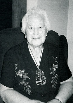
ヘイ・ティキを身につけたカイ・タフの女性
テ・ワヒ・ポウナム
ポウナムのステータスの高さは、南島のマオリ語の呼称「テ・ワヒ・ポウナム」(ヒスイのある場所)という名前にあらわされています。
Prestigious Pounamu
Treasures handed down through the generations
Pounamu/jade was a major source of wealth and prestige.
It was carved and fashioned into fabulous weapons, tools and ornaments. Patu pounamu or mere pounamu - hand clubs - were symbols of high rank in Maori society, as were finely-dressed adzes/toki. They became personally named heirlooms, handed down through the generations, displayed with pride on ceremonial occasions and cited when adventurous exploits were recounted.
Ornaments and amulets made from pounamu include the spectacular neck pendants Hei Tiki (stylised human image) and Hei Matau (stylised fishhook), and elegant ear pendants. Hei tiki, in particular, were renowned for their varying shades of green and their surface sheen.
Perhaps more than any other art form, pounamu taoka (treasures) distinguished Maori art from that of tropical Polynesia.
Te Wahi Pounamu
Pounamu's high status is reflected in the name of the South Island, Te Wahi Pounamu/The Place of Jade.
|