|
REAL-TIME COASTAL MONITORING SYSTEM USING WIRELESS INTERNET AND LIGHT TOWER
K.S.Park1 J.K.Lee2, S.W.Kang1 and S. I. Kim1
1Coastal and Harbor Engineering Research Laboratory, KORDI
Seoul, KOREA
kspark@kordi.re.kr
2DATAPCS,Co., Kyungki-Do, KOREA
ABSTRACT
Kyboncho and Sokcho station was successfully launched as a real-time coastal monitoring station in comply with the national coastal monitoring plan. Real-time coastal monitoring system using light tower and wireless Internet will produce valuable information to reduce natural disaster damages by tracking typhoons or measuring high waves or reporting strong northwesterly winds in winter season. Types of real-time information include wind speed, wind direction, air temperature, relative humidity, atmospheric pressure, wave, tide, water temperature and salinity. Data are collected regularly and transmitted to the main server using CDMA wireless Internet connection. After post-processing on the server, data are distributed to the users on the wired and wireless Internet same time.
INTRODUCTION
Korea has great demands for the efficient uses of her coastal space. Currently, several coastal projects are in progress along the coast of Korea such as harbor constructions, coastal industrial complex developments, land reclamations, artificial islands, and other coastal constructions. Also, marine transportations, fisheries, coastal recreations, and naval operations have been far increased due to the growth of the Korean society and economy. Therefore, coastal information is needed to support these activities more than ever.
KORDI has been carrying out a research project of the development of an Integrated
Coastal Monitoring Network, which is aimed for building an integrated coastal monitoring network of Korea
(Lee et al., 2000a, 2000b). The primary goal of
the system is to obtain enough coastal data sets in real-time by optimal utilization of the existing coastal
structures and the latest communication breakthrough. Several real-time coastal monitoring stations are
currently in operation and few are being constructed now.
This paper focuses on the setups of real-time coastal monitoring network using light towers and wireless Internet. The experiences of running the systems will be discussed. Especially, the elegant uses of wireless Internet based telemetering network and its superiority will be emphasized.
MONITORING SYSTEM SETUP
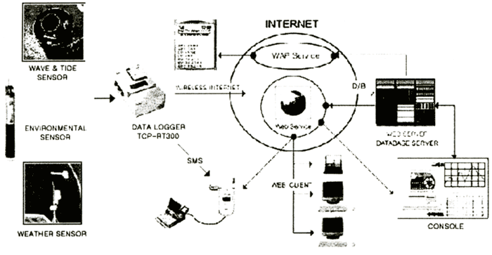
Data logging system (TCP-RT300) installed on a coastal light tower collects waves, tides, atmospheric and environmental data and transmits the data in real-time using wireless Internet at a preset interval. The uploaded data are then processed in different formats such as HTML or WAP (Wireless Application Protocol) and distributed to the users in real-time. The custom made data logging system, TCP-RT300 by DATAPCS, Korea, is a data acquisition device for the real-time data logging based on the CDMA (Code Division Multiple Access) wireless Internet technology. Besides the basic data logging functions, it is also capable of controlling systems and also providing multiple I/O. This system has been optimized for system power savings and easy maintenance. But the real-time capability anywhere and anytime in Korea makes it carry out the most functions wanted by researchers. The overall configuration of this system is given in Figure 1.
| (Enlarge: 33KB) |
 |
Figure 1. Monitoring network based on TCP-RT300 data logging system
The data controller has two independent processors. One is for the data logging and the other is for the watchdog purpose. These two processors really help each other to prevent the system from unexpected system holdings, which are frequent in coastal weather conditions and no serviceability in bad weather. The main controller is equipped with the 64 k program buffer, 32 k RAM for system memory, 32 k EPROM storage, a real-time clock automatically synchronized with GPS, a 16-bit pulse input, three relay contacts, 16 channel 12 bit A/D ports, a RS422 serial bus line, four software controlled RS232 lines, one hardware RS232 line, three digital I/O, and a digital GPS interface. By supporting many RS232 lines, the interfaces with YSITM environmental multi-pack sensors, AquatrakTM acoustic tide level sensor, ArgonautTM ultrasonic velocity meter, and Coastal system's AWS devices are supported simultaneously.
Though all the above interfaces are possible in other similar systems, but
the interfaces of the TCP-RT300 were designed for the multiple connections in wireless mode. Therefore,
the connection is more handy and effective compared with other systems in market. For example, SMS (Short
Message Service) and MTOM (Mobile to Mobile) and Multiple Internet Connection (MIC) are fully supported
in the default setup and thus the user can reach the system easily anytime and anywhere when they need
( Park et. al., 2000).
TELEMETERING METHODOLOGIES
The common method of telemetering in coastal environment is a wireless connection. It can be VHF or UHF radio modem connection or it can be a satellite connection such as InmarsatTM or OrbcommTM. But these two have their pros and cons in real use. The former is handy and less expensive, but it usually reaches only short distance with civil permission and less reliable. The latter can reach the globe but it is slow and very expensive to operate.
The recent development of land based CDMA wireless networks in Korea is quite impressive and gives lots of possibilities for the setup of real-time coastal monitoring purpose. Because these networks provide more than 64 k bi-directional data link and the full digital connection, the quality of data transmission surpasses any previous wireless methods. More than that, this network covers more than 20 km outside from the coastal line, thus most of coastal monitoring stations can be hooked up to the monitoring net.
The advantage of the new system is clear in budgeting, maintenance, system integration, speed, reliability, etc. For the simple comparison of this network to a satellite network shows eight times faster speed and 100 times in operating cost. And the power requirement of the system has decreased two or three times less. But the most promising feature is the do-it-yourself real-time wireless network design capability because all the devices are now available to public without license obligation.
Software of this system is divided into three parts. Field part is written with PICBASIC language from Compile Technology, Co. of Korea. Server part is written with JAVA for Unix environment and Visual Basic for Windows environment. Mobile part is written with WAP (Wireless Application Protocol). The software are tested and optimized under wireless conditions especially with LG 019 PCS (Personal Communication Service) network.
From the data acquisition to the final data distribution the total process takes less than 25 seconds. Five seconds are to connect a system to the network and another five to ten seconds for the data uploading process and ten seconds in the data processing and distribution. Thus 25 seconds later from the starting of data acquisition process, a user really can see field data on the Internet environment.
TYPES AND FUNCTIONS OF SENSORS
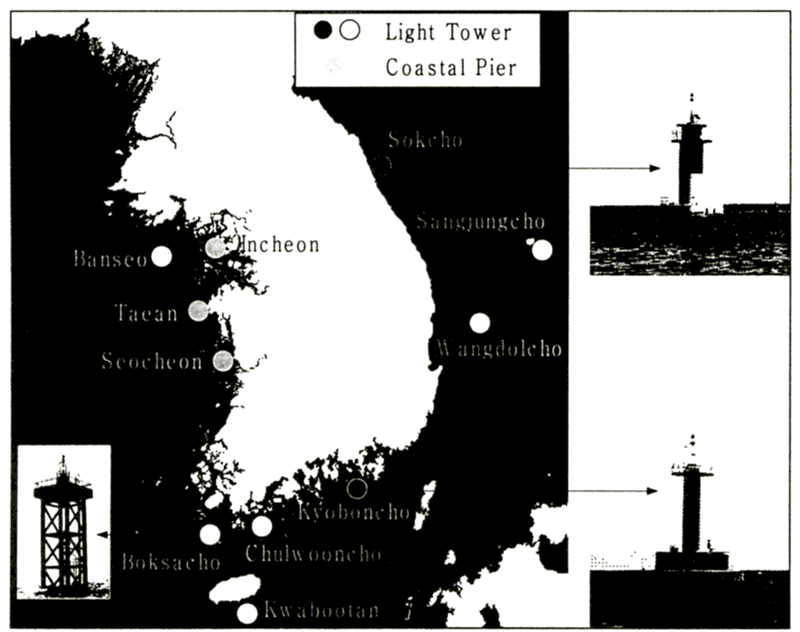
Sokcho and Kyoboncho coastal monitoring stations were successfully constructed and launched. The locations are drawn in Figure 2. Three more stations including Ulungdo station will be in service near future. Enabled by the real-time wireless Internet, these stations collect all kinds of coastal data and provide current status of coastal environments.
| (Enlarge: 44KB) |
 |
Figure 2. Locations of Kyoboncho and Sokcho station
The number of sensors in a station is typically five and observing parameters are eleven. Wave height, wave period and tide information come from an ultrasonic surface level sensor. Wind speed, wind gust and wind direction information come from a wind sensor. Temperature and humidity come from a temperature sensor and a humidity sensor. The atmospheric pressure sensor gives the air pressure reading. In some cases, an environmental sensor obtains water temperature and salinity information. Usual parameters collected from this system are listed in Tables 1 and 2.
Table 1. Sensors installed at Sokcho station
| Sensor |
Parameter |
Range |
Model |
Maker |
| Anemometer |
Wind speed・Wind direction |
0 to 60 m/s |
05106 |
R.M.Young |
| Thermometer |
Air Temperature |
-40〜 +60℃ |
HMP45A |
VAISALA |
| Humidity |
0〜100% |
| Barometer |
Air pressure |
600〜1060 hPa |
PTB101 |
VAISALA |
| UDM 200 |
Wave・Tide |
0.5〜60m |
UDM 200 |
DATAPCS |
| YSI 600R |
Water Temperature |
-5〜+45℃ |
YSI600R-C.T |
YSI |
| Salinity |
0〜70 PPT |
|
Table 2. Sensors installed at Kyoboncho station
| Sensor |
Parameter |
Range |
Maker/Model |
| Wind Direction Sensor |
Wind direction |
|
AANDERAA/MODEL 3560 |
| Wind Speed sensor |
Wind speed |
0-79m/s |
AANDERAA/MODEL 2740 |
| Air Pressure Sensor |
Air pressure |
920-1080hPa |
AANDERAA/MODEL 2810 |
| Air Temperature Sensor |
Air temperature |
-43〜+48℃ |
AANDERAA/MODEL 3455 |
| Relative Humidity Sensor |
Humidity |
0〜100% |
AANDERAA/MODEL 3455 |
| Salinity/Temperature Sensor |
Water temperature, salinity |
0〜40ppt
-7.5〜+41℃ |
AANDERAA/MODEL 3210 |
| AQUATRAK |
Tide |
0-15m |
AQUATRAK |
|
|