|
REAL-TIME ALARM FUNCTION
The new coastal monitoring network is designed to meet the basic needs of researchers and government officials and also civilians. But to the system manager independent anytime access to the system is anxiously needed and even "the must have option" for good maintenance. If Internet stops operations for hours, manager needs an access tool for checking field systems. In addition, if manager is away from Internet line, there must be a way to get information whenever some serious field conditions happen. If this kind of a handy alarm function exists, it will be very valuable to the system manager. Fortunately, this function is already built in this system through SMS service. Thus manager always can monitor the system status and happenings resulting in better system maintenance.
MOBILE DATA SERVICE
After sampling and transmitting to the server, raw data are stored in D/B and then processed in two viewable formats; HTML and WAP. Still, HTML format is more informative and fast to the Internet users, but it has a limitation of "go and check" philosophy. Thus when a user needs information on the road, he has to go to an Internet ready place to check information. In this sense, the value of real-time information is lowered. But the mobile format WAP can fill this gap between the out of office user and the real-time use. If someone has WAP ready compatible mobile phone, information goes anytime and anywhere. In Korea, the high-tech mobile phone uses are exploding and thus the service through this mobile phone is much practical. It's a very clear trend now.
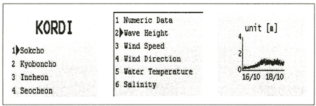
For example, WAP service of Sokcho station is illustrated in Figure 3. If a WAP user enters keys of the mobile Internet address, he can get the real-time coastal data on his phone. He can browse the information in text and graphic formats. Already five coastal monitoring stations are in service.
RECENT SYSTEM PERFORMANCE
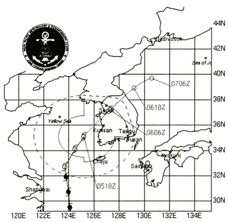
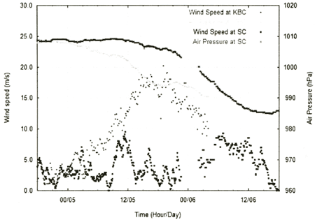
A tropical depression developed in the southwest pacific region on June 29 2002 and became a category 3 typhoon (named Rammasun) three days later. After passing through the Yellow Sea, it penetrated the Korean peninsula and then disappeared seven days later. The approach and landing of the typhoon on the Korean peninsula was monitored at the Sokcho and Kyoboncho stations. Figure 4 shows the typhoon track obtained from the U.S. Navy FMOC site and Figure 5 shows wind speed and air pressure fluctuations recorded at each station.
Figure 4. Typhoon Rammasun track report on July 4, 2002
Figure 5. Example of real-time data from the monitoring stations
It can be seen in Figure 5, the air pressure at Kyoboncho station (500 km eastside of typhoon center) dropped to 970 hPa and the wind speed was reaching up to 20 m/s. As a matter of fact, after five hours of peak detection of wind speed, the Kyoboncho system got a little maintenance problem, but it was repaired in two ways for its full function again.
CONCLUSION
Kyoboncho and Sokcho coastal monitoring stations were successfully launched a year ago according to the 10 year long national plan for the Korea coastal observation program. Compared with the old system, this new system is more efficient in real-time communication, maintenance cost, reliability, and user satisfaction. The exact time synchronization, two ways communication capability, and SMS function make the maintenance job much easier and thus result in overall system performance higher. Most of all, the most important feature of this new system is that it is Internet-ready at the field level.
This monitoring system will serve as following purposes. Firstly, valuable coastal data will be collected for the people who need real-time coastal information. Distributed over the Internet, data will be available to everyone who has access to the Internet. Secondly, these systems will provide more accurate scientific data sets to research community. Thirdly, Korea's coastal engineering standard will be updated and changed based on new statistics measured by this network. Fourthly, the experiences learned from this project will be used to the other areas such as real-time environmental monitoring, disaster prevention network and real-time weather monitoring. The remarkable wireless Internet network can really change and upgrade the real-time coastal information services to the public from the field data logger to the final data users.
ACKNOWLEDGEMENTS
The second author appreciates the partial support by a grant (1-1-1) from Sustainable Water Resources Research Center of 21st Century Frontier Research Program.
REFERENCES
Lee, D.Y. and K.S. Park. 2000a. Integrated Coastal Observing System. Technical Report, BSPM 99043-00-1259-2. Korea Ocean Research and Development Institute. p.617 (in Korean).
Lee, D.Y. and K.S. Park. 2000b. Integrated Coastal Observing System and Operational Korea Ocean Prediction System. Technical Report, BSPM 00050-00-1291-1. Korea Ocean Research and Development Institute. p.237 (in Korean).
Park, K.S. and D.Y. Lee. 2000. An Implementation Plan for National Ocean Monitoring Network: Real-time Coastal and Ocean Monitoring Network. Technical Report, PK00035. p.194. (in Korean).
Park, K.S., S.I. Kim, S.W. Kang, J.K. Lee and S.D. Kim. 2001. Real-time Tide and Storm Surge Monitoring System using Internet Wireless Modem. Proceeding of the Workshop on Meteorological Disaster of Natural Hazard Prevention Research. pp.51-59, (in Korean).
|