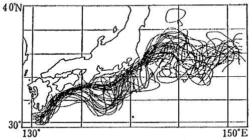
Fig.1. Position of the Kuroshio axis measured in the period from 1955 to 1964 (Masuzawa, 1965). The positions of the Kuroshio axis are determined from that of the isotherms of 15℃. The two stable paths of the Kuroshio are seen to the south of Honshu.
He calculated the sea level difference between these two oceanic stations (taking the reference level at 300 m depth) by using temperature and salinity data, and compared with the sea level difference between the two tide gauge stations. The result of their analysis is shown in Fig.2, which shows that the variation of the sea level difference between the tide gauge stations can be explained quantitatively by that of the oceanic structures of the surface 300 m layer. Fujita (1997) also investigated the relation of the sea level difference to the position of the Kuroshio axis: He determined the distance of the Kuroshio axis measured due south from Cape Shionomisaki by using the Prompt Report of Oceanographic Condition published bimonthly by the Hydrographic Department of the Maritime Safety Agency of Japan and calculated the bimonthly averaged sea level difference between Kushimoto and Uragami. He found that the Kuroshio takes the large meander path when the sea level difference is near or smaller than 25 cm (this value would be affected by selection of the reference levels of two tide gauge stations, but here we used simply the sea level values reported by Japan Meteorolgy Agency). Note that tidal components of the variations had not removed, but that the tidal components are very similar to each other and do not affect the results. The Kuroshio takes the straight path when the sea level difference is larger than this threshold value of 25 cm. However, it had not been clarified why and how such a sharp contrast of the oceanic condition is created between two adjacent points: the distance between Kushimoto and Uragami is only about 14 km.
Recently, a group which consists of the researchers belonging to Wakayama Prefectural Fisheries Experimental Station, Mie University, Marine Information Research Center of Japan Hydrographic Association, and Fisheries Research Center of Mie have made several detailed observations and analyses of the oceanic conditions in the vicinity of the Kii Peninsula and investigated their relations to the flow nature of the Kuroshio just off Cape Shionomisaki (the tip of the Kii Peninsula).