During the winter, the route shifts to the north. This shift is the result of extensive operating experience, through which mariners have learned to avoid the landfast ice along the coast in favor of the more easily navigable polynyas between the fast ice and the polar drifting ice. Note, however, that sufficient hydrographic surveys have yet to be conducted in the NSR, so the navigation of these challenging seas requires the expert skills of seasoned ship captains and pilots.
Ѓ@
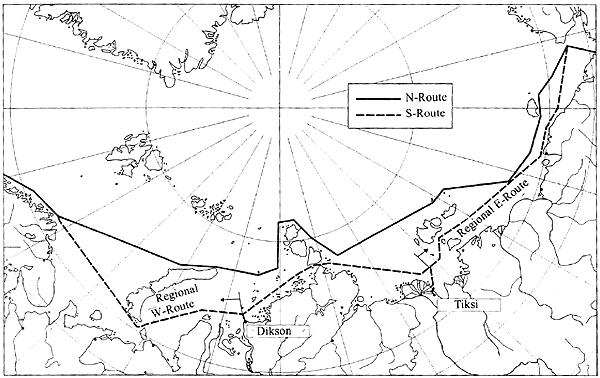
Figure 4.2-8 Routes selected by CNIIMF
Ѓ@
Various routes have been proposed in the course of INSROP Phase II, which is discussed in Section 4.4. The INSROP routes were based on a comparison of the economic performance of several routes in a simulation of voyages from Europe to Japan through the NSR (WP-164). The data on water depths and other key items for the simulations were gathered into segments set by CNIIMF at intervals of 20NM along a selected route through the NSR from Hamburg to Yokohama (Figure 4.2-8) (WP-108). The simulation focused on two types of NSR vessel, one a ship with moderate size and shallow draft, which was to follow the coastline, and the other a large vessel with a deep draft, traveling far offshore from the continent and islands. Two routes were thus selected, a coastal or "southern route" and an offshore or "northern route." Moreover, a further distinction was made in the southern route between a "western route" and an "eastern route," with the former traveling from Hamburg to a position off the port of Dikson, linking the Russian Arctic with Western Europe, and the latter tracing a path from a position off the port of Tiksi to Yokohama, to link the Russian Arctic with Japan. One of the objectives of the simulation for the two types of ships in different routes was to determine the most appropriate type of NSR ship. It was also expected that this simulation would provide useful information on optimum scheduling and routing, based on the natural conditions and the season of operation. The depth data from this study highlights the differences in depth between the two routes (Figure 4.2-9), offering a clear illustration of the problems of shallow waters along the Russian coast as discussed above. As the illustration makes clear, the eastern NSR is a continuous stretch of shallow water-especially along the coast of the mainland, where depths of a mere 20m are common.