Because a chain of islands exists between this current and the current flowing toward the Fram strait off the continental shelf, a complex, vortex-like flow pattern is generated in this area. The movement of sea ice in the center of the Arctic Ocean, which is unaffected by the coasts, are significantly affected by the long-term predominant winds, which generally follow the high-pressure contour line. The speed of its movement is 5% of the wind speed above the sea surface: if the wind blows at 10m/s, the sea ice drifts at about 0.5m/s, or one knot.
丂
3.3 Natural Conditions in the NSR
3.3.1 Geographical Environment
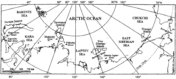
Broadly speaking, the NSR rounds the northern coast of the Scandinavian Peninsula, then passes in succession through the Barents Sea, Kara Sea, Laptev Sea, East Siberian Sea and Chukchi Sea to reach the Bering Strait. These seas are divided by groups of islands on the continental shelf: Novaya Zemlya, Severnaya Zemlya, the Novosibirskye Islands and Wrangel Island. Between these islands, or between the islands and the mainland, are a series of straits. A list of the major straits through which NSR ships must pass includes the Yugorskiy Shar Strait, which is located on the south coast of Vaygach Island and forms the southernmost entrance from the Barents Sea to the Kara sea; the Kara Gate Strait, the main shipping strait between the Barents and Kara seas; Vilkitskiy Strait, which separates Severnaya Zemlya from the northernmost extremity of the Eurasian continent, Cape Chelyuskin; Shokalskiy Strait, locating in Severnaya Zemlya north of the Vilkitskiy Strait; Dmitriy Laptev Strait, which is the southernmost passage between the Novosibirskye Islands and the mainland, linking the Laptev and East Siberian seas; Sannikov Strait, the second east-west passageway through the Novosibirskye Islands linking the Laptev and East Siberian seas; Long Strait, and which separates Wrangel Island from the mainland, linking the East Siberian and Chukchi seas. Most of these straits are notoriously perilous due to the heavy accumulation of deadly sea ice.
Because the entire length of the NSR lies over the continental shelf of Eurasia, the route comprises a large number of shallow zones. Although the western Barents Sea is more than 200m deep, the eastern Barents Sea is about 100m deep and the Kara Gate Strait is a mere 30m deep. The Kara Sea has numerous extremely shallow areas that are less than 100m deep, with numerous variations in depth, and some are as shallow as a few meters to 20m. In the Laptev Sea, which has the narrowest continental shelf in the Arctic Ocean, the NSR lies in deep seas, portions of which are over 1,000m deep. As one draws near to the Novosibirkye Islands, however, the sea becomes shallower than 20m, and both the Dmitriy Laptev Strait and the Sannikov Strait are roughly 20m deep; these areas are the shallowest parts of the NSR.
丂