Earth and soil that remains frozen through an entire summer and two winters or longer is called permafrost. Permafrost is found in Siberia, interior China, Alaska and northern Canada and accounts for 14% of the earth's landmass. The world's deepest permafrost is found in the Yakutia of Siberia, which is frozen to a depth of almost 1,000m.
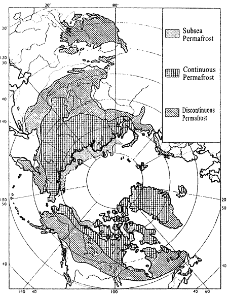
Permafrost may be classified as "continuous," meaning permafrost that extends unbroken both horizontally and vertically, or "discontinuous," which includes permafrost found in isolated patches. The map at right illustrates the distribution of these two types of permafrost. During the last glacial period, the continental shelf that was exposed above the surface of the ocean consisted of thick permafrost, which later sank beneath the ocean as the sea level rose. Because the water surrounding this shelf hovers around the freezing point of -1.5亷, and the water does not warm up much during the summer, this sunken permafrost (the "subsea permafrost" in the map) remains mostly frozen today. As the map shows, in the last glacial period the subsea permafrost extended across a remarkably broad area, encompassing the continental shelf from the Taymyr Peninsula to the Mackenzie River delta, which had not been covered by the Scandinavian and Laurentide ice sheets.
丂
Distribution of permafrost (Kinoshita, 1988)
丂
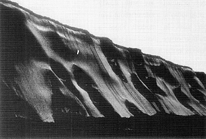
In contrast to this subsea permafrost, which was preserved at a uniform temperature, the continental permafrost was exposed to seasonal temperature variations of as much as 100亷 in a given year. Melted water would pour into the cracks formed during the winter cold and freeze to create ice wedges. Each year these ice wedges grew gradually, so that today great wedges can be seen around the coast of the Arctic Ocean. These ice wedges are so thick that they create the illusion of soil wedges penetrating deep into a huge block of ice. In the Lena, Yana, Indigirka and Kolyma river basins of Siberia's Arctic coast, cliffs of ice are apparent. These cliffs, called edoma ("corroded land"), were formed when the ice in exposed sections of permafrost and ice wedges melted rapidly.
In terms of NSR, the presence of permafrost must be taken into careful consideration in the design of port facilities and peripheral approaches, construction of navigational support systems and the execution of dredging operations.