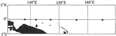
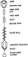
The ADCPs we have been using in the TOCS program are 150kHz Broad-Band models made by RD Instrument. The configuration of the mooring is shown in Figure 1b. An ADCP was attached through a hole of a spherical subsurface buoy and a CTD sensor, Sea-Bird model SBE 16, was attached at the bottom of this subsurface buoy to monitor depth variations of the ADCP as well as to monitor the ambient temperature. The heads of ADCP were looking upward and there were no other oceanographic instruments between this subsurface buoy and a sinker. The planned depth of this subsurface buoy was about 270-290m. By principle, upward looking ADCP can not measure currents near the surface and the upper boundary of our observation was 30-40m. The data correction procedure routinely applied to these data included correction of geomagneric anomalies, correction of depth variations of the ADCPs, linear interpolation when data were missing, and removal of spikes. The sampling interval of our observation was one hour. In the following section, we will limit our attention mostly to the zonal current data obtained at 147。?-O。?.
We also used TOGA/TAO data, TOPEX/POSEIDON data, NASA Scatterometer (NSCAT) data and European Centre for Medium-Range Weather Forecasts (ECMWF) wind data level III-A ECMWF/TOGA advanced operational analysis data sets, surface and diagnostic fields data set; 1.125 degree resolution) in this paper The TOGA/TAO data used here were daily means of temperature at 1, 25, 50, 75, 100, 125, 150, 200, 250, 300 and 500m at 147°E-0°N and 156°E-0°N and were obtained from the TOGA/TAO web site. At 147°E-0°N, temperatures at 25, 75, 125, 200 and 300m became available after February 18, 1997, and missing data were interpolated vertically by applying Akima's spline which was included in IMSL subroutine package. Data missing at all depths were linearly interpolated in time. The TOPEX/POSEIDON data were obtained from the MGDR-B CD-ROM, and we applied a bell shaped smoothing function to these data to obtain gridded data at first. After this, we computed anomalies from the mean values which were the averages from 1993 through 1995. Resultant anomalies were averaged meridionaly from 2°N to 2°S, excluding those over the land. The NSCAT data (Level 2) were obtained from the ADEOS web site, and we applied the three-dimensional spatial-temporal interpolator described by Zeng and Levy (1995) to obtain smoothed daily grided data. The horizontal range is 300km and the tempora range is 24 hours. The processing of NSCAT data is still the subject of on going research and we used NSCAT data for only qualitative purpose. In this paper, “low-pass filter” refers to a low-pass filter with a cut off period at 10 days unless otherwise specified. Wind stress was computed with drag coefficients described by Large and Pond (1981).