The need for a real-time long term observational system is clearly needed to understand these phenomena in the Arctic Ocean.
丂
ARCTIC CLIMATE OBSERVATIONS using UNDERWATER SOUND
丂
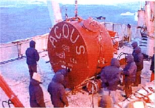
On October 9, 1998 the first acoustic source as part of the ACOUS project was deployed in the Franz Victoria Strait at 81亱55.88' N and 38亱43.94' E (Fig. 2). The source is moored from the bottom at a depth of 60m below the surface. The source is autonomous, battery powered, and transmits ten 255 digit M-sequences (each digit is tencycles at 20.4901238Hz with a modulation of 亇60亱for a total signal duration of 20.74 mins) every four days at 0000Z. The first regular transmission was at 0000Z on October 15, 1998. The source level is 195dB or 250W of acoustic power and is designed to operate for 2.5 to 3 years unattended. The transmission time is controlled by a rubidium clock that was synched to GPS just prior to deployment.Because a 255 digit M-sequence is used there are sixteen possible orthogonal codes that can be used. On every transmission the source monitors its output power and on the next transmission transmits the code that corresponds to one of sixteendB levels in .5dB increments so that a calibrated propagation loss measurement can also be made. This will be used to determine changes in the ice thickness and roughness along the propagation path, by comparing modeling results with the measured data. Satellite measurements including RADARSAT along the propagation path is planned as an additional source of data that can be used to determine ice-type and conditions to be compared with the acoustically derived and modeled results. The ultimate goal of this effort is to develop a reliable technique for estimating the volume of sea ice in the Arctic using the expanded monitoring grid contemplated in the final section of this paper.
Fig. 2丂ACOUS source being installed from the Russian icebreaker Academic Fedorov in the Franz Victoria Strait, Oct. 9, 1998.
丂
At the same time that the source was installed an American/Canadian team was in the Lincoln Sea (Fig. 1) deploying an autonomous receive array. This array (Fig. 3) is moored from the bottom in 545m of water at 84亱3.406' N and 66亱24.924' W. There are eight hydrophones spaced at 70m intervals starting at 12m from the bottom. The array also has five self-recording micro-CTD's that record temperature and salinity every ten minutes. There are two self-recording transceivers on the array that interrogate three bottom-mounted transponders to measure the shape of the array. The array is designed for an 18-month life, and recovery and data retrieval is planned for the spring of 2000. This source receiver pair creates a propagation path that crosses the eastern Arctic just north of the Fram Strait(Fig. 1).