|
Annex 1 - Keynote Speech - November 2005
Mr. Clive Davidson,
President, IALA
CEO, AMSA
The technology to enable long-range identification and tracking (LRIT) is not so much an issue as the functional requirements and the various mechanisms that need to be implemented to bring it into being. These requirements and mechanisms will need to be agreed upon by the world's maritime community, and therein lies the challenge for us at this workshop.
At the last workshop held in Victoria, Canada, in November 2004 and at the 10th International VTS Symposium held in Hong Kong earlier that same year, there was general agreement that LRIT already exists in various guises and that it potentially offers many benefits if the current low level of international cooperation can be increased.
Similarly, it has been widely agreed that the sharing of information between VTSs, MRCCs, Port Authorities and ships offers benefits for safety, security and traffic management. There is no doubt then that there are many reasons for coordinated worldwide LRIT of ships, not the least of which is security. Other reasons, such as safety and environmental protection, are also important and for some countries the addition of these reasons could well tip the balance and provide the necessary justification to secure their participation in LRIT. It cannot be denied that a lack of policy, functional specifications and the mechanisms for international cooperation are the primary challenges we face in establishing LRIT.
While there is good progress at IMO on the requirements and mechanisms for LRIT, much can be done to augment those efforts, so as to meet the deadlines for finalisation in 2006. A second, and equally important aim of this workshop should be to explore the use of LRIT for VTS and new initiatives such as e-navigation.
The world of marine navigation is on the cusp of change as computerised methods are set to augment and then replace traditional labour intensive processes. No longer will mariners rely solely on the taking of compass bearings and radar ranges, and their subsequent plotting on a paper chart, to determine their position when coasting. Already mariners are being exposed to ECS's and 'private' chart data and thus are increasingly becoming aware of the potential benefits and possibilities on offer from the use of electronic navigation.
There is mounting evidence that the production of ENCs is accelerating and consequently ECDIS is fast becoming a viable option in many parts of the world. Once this occurs, and IMO decides on the matter of carriage requirements for ECDIS, mariners will be seeking the provision of navigation supporting and enabling information in a format that can be electronically displayed on the bridges of ships.
Supporting and enabling information currently includes navigational warnings and safety information, chart corrections, notices to mariners and meteorological information. AIS and ship traffic information provided by VTSs are other sources of enabling information. The provision of all this information and its integration and display onboard a ship is effectively e-navigation. E-navigation is a significant potential user of information derived from LRIT and exploring this subject area has been identified as one of key tasks for this workshop.
When exploring the relationship between LRIT, VTS and e-navigation it needs to be borne in mind that mariners will be expecting to benefit from LRIT. This might be possible by the provision of improved awareness of nearby shipping, but there could well be other ways that mariners might benefit. In its current form, LRIT architecture does not readily permit the two-way flow of information, but this is not to say that this won't be possible in the future.
There are other areas that this workshop will need to consider:
・What are the key drivers for LRIT? There is no doubt that security is the key driver and for many countries the successful implementation of LRIT will be made possible through their government's commitment to enhancing security. However, ways to bolster the likely success of LRIT by not ignoring other drivers, in particular safety and environmental protection, need to be considered such that the use of LRIT information for reasons other than security is not prejudiced.
・What functionality does the end user require? Recent discussions have highlighted a diversity of views with respect to the functional requirements that should define an LRIT service. Key issues requiring consensus include: latency of position reports, accuracy of data and frequency of reporting. A common understanding of the functional requirements to deliver a security-based system is critical and may require some tough decisions. Some existing equipments may not meet the functional requirements agreed to, and consideration may need to be given to not including such equipment or adopting "grandfather" provisions.
・What is the appropriate extent (or range) of LRIT coverage? Specifying fixed ranges for LRIT coverage has been and is problematic due to different countries having different requirements driven by their coastline geography. For example, countries with a combination of land and sea boarders and with few offshore interests are likely to be interested in relatively small areas of sea for LRIT. Conversely, island nations with remote offshore territories are likely to be interested in obtaining LRIT information over large areas. In addition, countries with extensive areas of SAR responsibility will be interested in using LRIT information covering those same extensive areas. Having said this its understood that the current consensus is leaning towards a figure of 1 200 nm.
・What data is to be reported (e.g. position, course, speed, cargo, destination etc)? The answer to this question will have consequences on the required ship-borne equipment, the need for mariner intervention/input and possible mariner training, establishment and ongoing costs, and also the utility of LRIT data for other than security purposes. It is suggested there are advantages in commencing LRIT with the minimum amount of reported data since the inclusion of too much information may complicate or even jeopardise LRIT. It will always be possible for LRIT to be periodically reviewed and incrementally enhanced as experience is gained and as yet unforeseen opportunities emerge.
・Technology impacts, such as the various ranges differing technology permits, and data fusion at the point where LRIT information will be aggregated, needs to be considered. This is a detailed and technical subject area and may not be directly relevant to the establishment of LRIT, but it is certainly relevant to the performance of LRIT in terms of area of coverage. The fusion of data from other sources, for example AIS, will provide technical challenges, but it can also provide a method of validating LRIT information (or vice versa - LRIT validating AIS).
・What should be the nature of the controlling/authorised LRIT oversight body? It is important that any overarching controlling body for LRIT be impartial and that there be appropriate communications systems and security between vessels and the controlling body, and also between the controlling body and end users.
・Where should LRIT guidance be laid down - in SOLAS Chap V or SOLAS Chapter XI-2? There are pros and cons for either chapter of SOLAS. Chapter XI-2 would provide maximum benefit for the quick establishment of LRIT for use in the enhancement of security. However, Chapter V might be a better choice to help facilitate the use of LRIT for a wider range of uses, in particular navigation safety. It is suggested that it might not matter greatly whether it be Chapter XI-2 or Chapter V.
・Who should bear the cost of LRIT? At the previous workshop it was agreed that end users should bear data transmission costs. However, there are other costs and the overall costing of LRIT could be complex and the exact formulation of cost attribution is probably best left to the IMO in conjunction with the LRIT controlling oversight body. This is not to say though that this workshop should ignore cost issues but instead the higher-level policy aspects of costing should be discussed and any useful advice be captured and included in the workshop outcomes. Consideration should be given to acquisition and operating costs with respect to the selected technology, having regard to the cost effectiveness of the chosen technology. Most importantly though, costs will need to be borne by the beneficiaries of LRIT.
It is asked that this gathering work through the above considerations, plus other relevant key areas of LRIT, with the aim of providing answers and proposed methodologies to help facilitate the introduction of LRIT in a way that will provide maximum benefit to all.
More particularly this workshop should:
・Clarify other potential uses of LRIT information (e.g. VTS, e-navigation, navigation safety and environmental protection),
・Develop a common understanding of LRIT functional and technical requirements, and any political/legal implications for the delivery of LRIT,
・A definition of LRIT in the overall concept of e-navigation,
・A definition of roles and responsibilities within a world-wide LRIT arrangement, and
・A cohesive report to be considered by the MSC Intersessional Working Group on LRIT, aimed at assisting that group report to COMSAR in March 2006.
IALA is uniquely placed to facilitate debate on these issues and lead the way, just as it has done in recent years with the technical and operational development of AIS and the coordinating role it has provided with the evolution of VTS.
Annex 2 - Programme IALA Global Tracking Seminar
Tuesday, Nov. 8th, 2005
1600 - 1800 Registration - Grand Plaza Parkroyal Hotel Lobby area
1800 - 2000 Welcome Reception, Klix Lounge
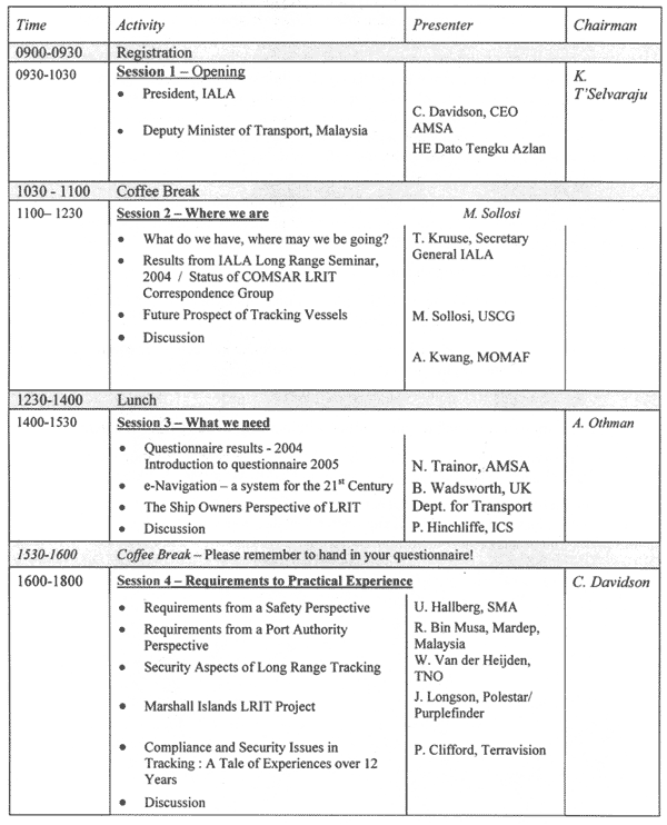
Wednesday, Nov. 9th, 2005
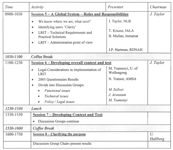
Thursday, Nov. 10th, 2005
Evening Activity - Seminar Dinner in the Plaza Ballroom
Meet and greet at 193O for dinner at 2000,
Dress - smart casual (no ties or jackets)
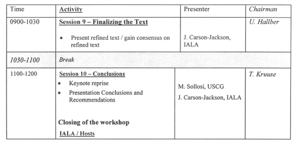
Friday, Nov. 11th, 2005
Lunch will be provided iminediately following the closing of the seminar.
A CD of the Seminar will be prepared and available after the Lunch. Please remember to collec tyour CD from the Seminar Reception Desk.
A Technical tour to the VTS and AIS Centre will leave at 133O from the hotel, returning at 1800.
|