|
APPLICATION OF FUSION TECHNIQUE IN DISPLAY OF AIS AND ARPA
Takehiro YAMASHITA (FURUNO Electric Co., Ltd., Japan)
Masakazu INOUE (FURUNO Electric Co., Ltd., Japan)
Yoshiyuki MIYAZAWA (Communications Research Laboratory)
Abstract: The series of evaluation trials on the AIS transponder was performed under the laboratory conditions by ARPA and AIS simulators and off Nishinomiya Harbor in Japan using 4 AIS transponders, which were fitted on individual crafts as mobile ship stations and an ARPA ashore as a shore station. Displaying AIS targets and ARPA targets on a PC screen on which the electronic navigational chart could be superimposed made various comparative studies. It was assured that the AIS was the very effective system to provide seafarer and VTS with information of the objects even in the lee of an island which cannot be detected by radar, as far as been within the VHF band coverage. Moreover, the faster response to the alteration of ship's speed and course during turn was obtained by AIS than by ARPA. The ARPA image is updated per radar scan though its targets are subjected to be lost or swapped. On the other hand, AIS targets are updated at the specified rate depending on ship's speed and rate of turn, but its update rate is slower that the one of ARPA. Consequently, it was also recognized that there were some difficulties to determine whether or not the displayed echoes from AIS and ARPA represented the same target especially in the congested area. When both ships with and without AIS transponder are in proximity, it is difficult for their echoes to be individually identified when the AIS target is to be superimposed upon the ARPA target. Where both AIS and ARPA target echoes represent the same ship, the fusion is the effective form of presentation in which only the AIS target echo is indicated. In order to realize this, it is inevitable that the criteria to consider the displayed echoes as a same target have to be established. The future ship-maneuvering simulator will incorporate both ARPA and AIS simulators. We believe that the establishment of such criteria is a key to success.
1. INTRODUCTION
The Automatic Identification System (AIS) was ordinary developed to aid the Vessel Traffic Services (VTS) by use of VHF transponder working on Digital Selecting Call (DSC) at VHF Channel 70 and still in use along the UK coastal areas and others. Afterward the IMO developed a Universal AIS using the new sophisticated technology called Self-Organized Time Division Multiple Access (SOTDMA) based on a VHF Data Link (VDL).
This system is synchronized with GPS time to avoid conflict among multiple users, and the system performance required is minimum 2,000 reports per minute in case of IMO and 4,500 reports on two channels in case of IEC[1],[2],[3].
The system operates in 3 modes;
(a) autonomous
(b) assigned and
(c) polled.
The VHF channels 87B and 88B are commonly used and in addition there are local AIS frequencies. The ship-borne AIS transponders exchange various data as specified by the IMO and ITU on either frequency management tele-command received by the DSC receiver on board.
In this system, many kinds of data should be transmitted by each vessel navigating in water, and these data include static data, dynamic data, Voyage related data and short safety-related message.
This implementation schedule of Universal AIS (UAIS) was already started in last July for new building ships of more than 300GT on international voyages, cargo ships of more than 5OOGT and passenger ships on all voyages, and since July 2002 this schedule will be executed for all of ships.
The new system to gain the information of target ships on board is starting now as described above. On the other hand, conventional way to gain information of target ships is used by RADAR and ARPA complying to IMO MSC 64(67) Annex 4, IMO A.820 (19) and IMO A.823 (19).
In navigation, especially in restricted water where many target ships would be coming to own ship, it is often to compare to target ships' data with RADAR/ARPA and/or AIS. It is very important for ship's operator to understand the difference between this information, and to take a fusion of these. So, in this paper, the authors took an investigation evaluating difference between RADAR/ARPA and AIS, and propose an application of a fusion technique in ARPA and AIS display.
2. INVESTIGATION OF EVALUATION
Here, we executed the investigation evaluating the differences between RADAR/ARPA and AIS using AIS simulator and on board investigation. First we evaluated the performances required of plotting type AIS transponder using AIS simulator, after then executed investigation on board. In this chapter, the method and results of the investigation of evaluation are discussed.
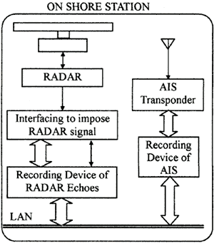
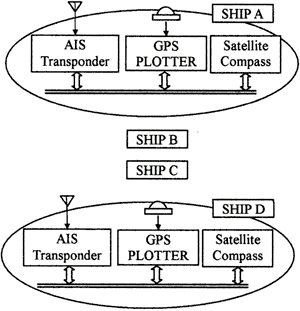
Fig.1 Investigation of evaluation
2.1 Method
The investigation of evaluation on board was executed using one base station on the shore and four ship stations, these constructions were illustrated in Fig.1 and the details of specifications of stations was described in Table 1.
Table 1 Specifications of stations
| |
Base Station |
Ship Stations |
| No. of Stations |
1 Station |
4 Stations |
| Location/Maneuverability |
|
1 ship of which maximum speed is
more than 24 knots. |
| Maneuvering Area |
--- |
According to scenarios off Nishinomiya
in Osaka bay |
| Radio Equipments |
1. UAIS Transponder |
1 unit |
1. UAIS Transponder |
1 unit |
| Type |
16K0F1D |
Type |
16K0F1D |
| Frequency |
161.65MHz |
Frequency |
161.65MHz |
| 161.75MHz |
161.75MHz |
| 161.85MHz |
161.85MHz |
| 162.00MHz |
162.00MHz |
| Transmitting-Power |
10W/2W |
Transmitting-Power |
10W/2W |
| 2. RADAR |
1 unit with ARPA |
2. Radio Transceiver |
1 unit |
| Type |
50M0P0N |
Frequency & Type |
A3E, 27876KHz |
| Frequency |
9410MHz |
Transmitting-Power |
1W |
| Transmitting-Power |
4.9KW |
3. GPS Plotter |
1 unit |
| 3. Radio Transceiver |
1 unit |
4. Satellite Compass |
1 unit |
| Frequency & Type |
A3E, 27876KHz |
|
|
| Transmitting-Power |
1W |
| 4. Interfacing |
1 unit |
| 5. Recording Device |
1 unit |
|
The shore station was used to communicate between ships' stations with TDMA, to record and to evaluate communication between all stations. The magnitude of communication errors was recorded quantitatively using measurements of packet error rate, and the correlation-ship between AIS information and RADAR/ARPA information was evaluated. The ships' station communicated duplex ship's data with TDMA.
We investigated to evaluate following items;
(a) Difference of target information between RADAR/ARPA and AIS
(b) Communication coverage
(c) Display
■ In a case of confusing area
■ Necessity of ship's trace
■ Display of anchoring ships
■ Imposing with ARPA symbols
■ Imposing with RADAR echo-trail
■ Evaluation of colored AIS symbols
and we made several scenarios to evaluate items described above.
|