|
MULTI-SATELLITE SENSOR APPROACH FOR PREDICTING SPILLED OIL IN JAPAN SEA
Katsutoshi Kozai
Kobe University of Mercantile Marine
Kobe, Hyogo, JAPAN
kouzai@cc.kshosen.ac.jp
ABSTRACT
Since January 1997, numerous investigations have been undertaken for predicting the path of spilled oil from the tanker Nakhodka by using physical models, satellite and ground-based remote sensing techniques. However, the optimal combination of satellite-derived products for predicting the path of spilled oil is not fully explored. The purpose of this study is to propose an approach for predicting the drifting path of spilled oil by using multi-satellite microwave sensors. Geostrophic current vectors are derived from TOPEX/Poseidon altimeter and surface wind vectors are derived from ADEOS/NSCAT scatterometer. These two satellite-derived products are used for predicting the drifting path of spilled oil from the tanker Nakhodka Distribution of spilled oil is identified by sequential RADARSAT synthetic aperture radar images. Trajectories of spilled oil signature derived from the sequential RADARSAT images are evaluated by the combination of alternater-derived geostrophic current vectors and the scatterometer-derived wind-induced drift vectors. It is found out that the estimated trajectory is agreed well with the one from the RADARSAT and is affected by the small scale cyclonic eddy appeared in the sea surface topography from TOPEX/Poseidon in the short temporal scale.
INTRODUCTION
In January 2, 1997 the tanker Nakhodka sank in the southern part of Japan Sea. The bow section of the tanker and associated spilled heavy oil were drifted to the coast of northern Japan and caused the worst oil spill disaster ever before. Furthermore the sunken tanker including about 6000 kilo litter of heavy oil at the time of accident continued to spill more than a couple of months. The study area with four TOPEX/Poseidon orbits and the locations of the sunken tanker and the JMA buoy 21002 are shown in Figure 1. Spilled oil has been monitored by various airborne and satellite sensors (NASDA, 1997, Kozai, 1999). However the use of satellite remote sensing techniques are limited in each sensor and the optimal combinations of satellite sensor for spilled oil are still under investigation. This study proposes an approach for predicting the drifting path of spilled oil by using multi-satellite microwave sensors, namely RADARSAT, TOPEX/Poseidon and ADEOS/NSCAT.
SATELLITE AND IN SITU DATA
RADARSAT and spilled oil signature
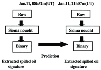
RADARSAT launched in 1995 by the Canadian Space Agency is the first Canadian remote sensing satellite with C-band Synthetic Aperture Radar (SAR). Table 1 shows the characteristics of RADARSAT standard beam mode (Canadian Space Agency, 1994) and Figure 2 illustrates the RADARSAT image analysis procedure for extracting spilled oil signatures. One of the notable features of RADARSAT is the variable incidence angle which is ranging from 20 to 49 degrees.
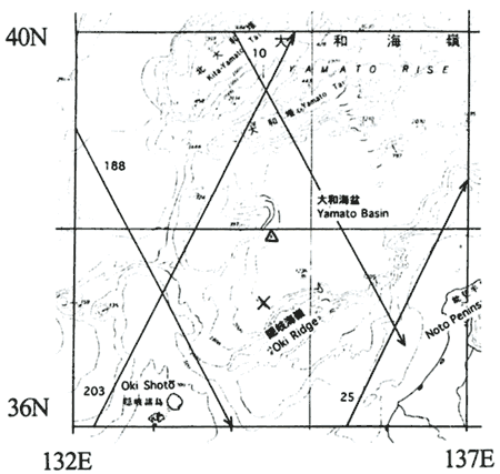
Figure 1. Study area with four TOPEX/Poseidon orbits (10, 25, 188, 203)
(X and △represents the location of sunken tanker Nakhodka and the buoy 21002 respectively)
Table 1. Characteristics of RADARSAT Standard beam mode
| Frequency |
C band (5.3GHz) |
Incidence angle |
20〜27°(beam position Sl) |
| Polarization |
HH |
|
24〜3l°(beam position S2) |
| Swath |
100km x 100km |
|
30〜37°(beam position S3) |
| Resolution/beams |
30m/7 |
|
34〜40°(beam position S4) |
| Orientation |
Right |
|
36〜42°(beam position S5) |
| Altitude |
798km |
|
41〜46°(beam position S6) |
| Orbit type |
sun-synchronous dawn-dusk orientation |
|
45〜49°(beam position S7) |
|
Figure 2. RADARSAT image analysis procedure for extracting spilled oil signatures
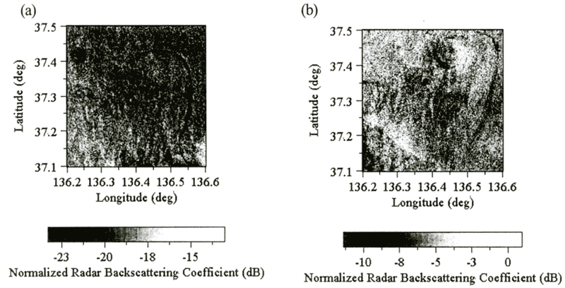
In this study the SAR images taken at January 11,08h 52m (UT) and January 11,21h 07m (UT) are geometrically and radiometrically corrected and used with the standard beam positions S5 (ascending orbit) and S1 (descending orbit) respectively. According to Table 1 the incidence angle of the first image (January 11, 08h 52m) is about 16 degrees higher than the one of the second image (January 11, 21h 07m), which leads to the darker brightness values of the first image than the one of the second image shown in Figure 3. In general synthetic aperture radar images include inherent noise called speckle. In order to remove the speckle various methods have been developed (Lee, 1983). In this study the median filter with the window size 3x3 is applied for all images. After the speckle removal the conversion from raw digital counts of the images to normalized radar backscattering coefficient (sigma nought) is carried out as described below because the sigma nought is known as the representative of the physical feature of sea surface (Shepherd, 1997). Since the sigma nought α is derived from the beta nought (radar brightness value), extraction of beta nought β is also expressed as follows.
βj=10 x log10{(DNj2+A3)/A2j}(dB)
(1)
where A2j is the scaling gain value for the jth pixel and A3 is the fixed offset.
σj=βj+10 x log10(sinlj)(dB) (2)
where lj is the incidence angle at the j th range pixel. Figure 3 shows the extracted study areas expressed as sigma nought Lower sigma nought values for each image are corresponding to spilled oil because of the damping effect of the radar illumination. In order to extract and compare spilled oil signature with different dates the binary classification is applied for both images based on the threshold values determined by the manual interpretation of the images. Figure 4 shows the histogram of the study areas of Figure 3 and Figure 5 illustrates the binary image extracted from Figure 3 based on the threshold values of -21 dB and -8 dB, respectively. A brighter curve-like spilled oil signature is clearly apparent in January 11,08h 52m (UT) image. However, the curve-like signature seems to be diffused at the northern and eastern portion of the image (January 11, 21h 07m(UT)) after 12 hours. These two curve-like signatures are later used for the prediction approach.
| (Enlarge: 64KB) |
 |
Figure 3. Spilled oil features observed by RDARSAT ((a) January 11,08h
52m (UT), ascending orbit beam position S5, (b) January 11, 21h 07m (UT), descending orbit beam position
S1).
|