|
HEAT TRANSPORT TO THE NORTHWEST JAPAN SEA: SIMULATION WITH THE MHI MODEL
Olga Trusenkova1, Vladimir Ponomarev1 and Hajime Ishida2
1V.I. Il'ichev Pacific Oceanological Institute
Vladivostok, Primorskii Krai, RUSSIA
2Faculty of Engineering, Kanazawa University
Kanazawa, Ishikawa, JAPAN
trolia@poi.dvo.ru
ABSTRACT
Circulation, heat transport, and air - sea heat fluxes in the Japan Sea are
simulated for two climatic regimes of mid and late 20 th century. The MHI numerical
model ( Shapiro et al., 1998) is applied for simulations. Two short-term
experiments are performed for the external and initial conditions of the 1950s or 1990s based on meteorological
and oceanographic observations. Simulation results suggest that re-distribution of the Tsushima Current
transport between western and eastern branches and thermal regime of the northwest Japan Sea is highly
affected by conditions of decreased baroclinicity in the 1950s or increased baroclinicity in the 1990s.
Intensification of the simulated East Korean Warm Current (western branch) in 1999 associated with increased
baroclinicity facilitates heat transport to the western and central sea area. In winter, heat loss at
the sea surface and convection depth is decreased in 1999, compared to 1950.
INTRODUCTION
Wintertime interdecadal warming in the atmosphere over many regions of Northeast
Asia, in particular over the adjacent Japan Sea area is supported by numerous observational evidence ( Ponomarev
et al., 2001 a and refs. therein). It can be demonstrated by the increase of wintertime air temperature
over the Japan Sea from 1950 to 1990, reconstructed from data of 20 meteorological stations around the
Sea (Fig.1a). Warming is especially high (up to 5℃ for January (Fig.1a)) over the northwest Japan Sea
off Vladivostok, an area of increased wintertime air - sea heat turbulent flux ( Kawamura
and Wu, 1998) and of deep winter convection ( Talley et al., 2002). Conditioned
by atmospheric warming, potential temperature has increased in thermocline and deep water of the Japan
Sea from mid to late 20 th century ( Ponomarev et
al., 2001a and refs. therein).
In our previous studies, we focused on modeling of circulation patterns in
the Japan Sea, associated with climate change ( Ponomarev et al., 2001b;
Trusenkova et al., 2003). The purpose of this paper is to numerically simulate an impact of climate
change on heat content and transport in the sea. The results on circulation are only briefly discussed
with regard to their contribution to heat advection and air - sea turbulent heat flux.
SETUP OF NUMERICAL EXPERIMENTS
The MHI model ( Shapiro, 1998) is a primitive
equation model in isopycnic coordinates under hydrostatic, Boussinesq, and β-plane approaches. It is a
good tool for simulating jet currents, fronts, and winter convection by entrainment/subduction and layer
outcropping devices. In the MHI model, seawater temperature, salinity, and buoyancy are allowed to vary
horizontally in any layer, facilitating simulation of subduction and variation of water properties throughout
the sea. Stable vertical stratification is maintained by introduction of "base" buoyancy to constrain
buoyancy variations in inner layers: a layer outcrops if buoyancy gets out of its base limits; density
variations in the upper layer are unbounded. The upper mixed layer model incorporates the balance of turbulent
kinetic energy. Air - sea heat and freshwater fluxes are calculated by considering the complete (non-linear)
heat balance and prescribed precipitation. Table 1. Experimental setup
| |
1950 Experiment |
1999 Experiment |
| Model domain |
127°- 142°E, 34°-52°N |
| Inflow ports |
Western and Eastern Tsushima Channels |
| Outflow ports |
Tsugaru and La Perouse (Soya) Straits |
| Horizontal resolution |
1/8°; 10km W - E, 14km N - S |
| Number of layers |
7 |
8 |
| Time step |
5 min |
| Starting date |
1 st of January |
1st of June |
| Bi-harmonic viscosity |
1017 cm4/s
equivalent to 10 5 cm2/s for the 1/8°mesh |
| Harmonic diffusivity |
107 cm2/s |
| Diapycnal diffusivity |
5・10-6 cm/s equivalent
to 2.5・10-2 cm2/s
(for 50 m thick layer) |
| Base buoyancy (cm/s2) |
∽,2, 1.6, 1.3, 1, 0.8, 0 |
∽,2.4, 1.8, 1.4, 1.05, 0.87, 0.8, 0 |
| Data for initial interfacial surfaces |
R/V "Vityaz" 3rd cruise, January
- February 1950 |
cruises of R/Vs "Roger Revelle" and "Prof. Khromov", June - August 1999 |
| Inflow transport |
Sinusoid with extreme values of 3Sv/2Sv for September/March |
| Outflow transport |
Divided between Tsugaru and La Perouse Straits as 2:1 |
| T and S of inflow water |
From monthly climatology |
| Air - sea fluxes: |
|
| Wind stress |
Neglected (set equal to zero) |
| Freshwater flux |
Neglected (precipitation balanced by evaporation; no runoff) |
| Net downward radiative flux |
From climatology; seasonally varied but constant over the sea |
| Turbulent heat flux |
Calculated from bulk formulas |
| Sea surface temperature |
Temperature of the upper layer calculated by the MHI model |
| Surface air temperature |
Monthly mean for 1950 |
Monthly mean for 1990 |
| Wind speed |
5 m/s, constant in time and space |
| Air relative humidity |
0.7, constant in time and space |
|
The model domain covers the Japan Sea from Tsushima Island to Tatarsky Strait;
model bottom topography is presented in Figure lb. Two short-term experiments are performed (integration
up to three years; results are discussed for August and February of the third year) for the external and
initial conditions of 1950s and 1990s based on meteorological and oceanographic observations. The experimental
setup is basically the same as in ( Trusenkova et al., 2003); model domain,
simulation parameters, and data used are summarized in Table 1. Initial interfacial surfaces are taken
as isopycnals corresponding to base buoyancy of the layers. In both cases, initial interface topography
(shown in (Figs.1b, c; Trusenkova et al., 2003)) exhibits doming structure
typical for the cyclonic gyre in the northwest Japan Sea and large-scale depression in the subtropical
area. Features specific for the climatic regimes are consistent with decreased baroclinicity in the Japan
Sea in 1950s or increased baroclinicity in 1990s. Initial layers are isopycnic with uniform temperature
and salinity within every layer. 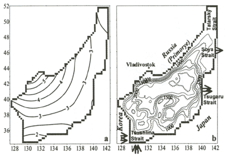 Figure 1. Air temperature increase (℃; for January) from 1990 to 1950 (a)
and model domain and bottom topography (b;m; hatches downhill, contours every 250m) for the Japan Sea
The difference between two climatic regimes is analyzed, associated with change
of buoyancy forcing at the sea surface. As inflow transport and water characteristics in the Tsushima
Strait are the same, air temperature and SST (temperature of the model upper layer) are two parameters
affecting air - sea heat flux which vary in time and space and are different for both experiments. Air
temperature is subjected to climate change and SST depends upon circulation in the Japan Sea and air -sea
heat flux. Wind stress is usually considered as principal forcing for numerical models. However, principal
features of the Japan Sea general circulation, such as the separation of the western boundary current
from the coast and formation of the cyclonic gyre, can be explained by surface thermal forcing only, with
surface cooling and wind stress acting in the same way ( Seung, 1992). Ekman
transport and Ekman pumping is neglected due to the lack of direct wind forcing in our experiments. Realistic
large-scale and mesoscale circulation can be simulated this approach ( Trusenkova
et al., 2003). |