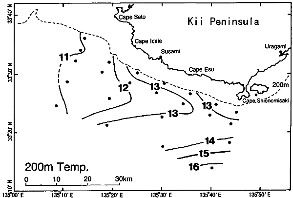
Fig.8. The same as in Fig.6 except for the temperature field at 200 m depth.
The westward flowing portion to the west of Susami may be related with a counter-clockwise eddy in the Kii Channel (Fujita et al., 1998; Nagata et al., 1998), which is often observed when the Kuroshio takes the straight path. However, the relation has not been clarified yet, as only one observation line of Wakayama Prefectural Fisheries Experimental Station runs in north-south direction along the center of the Kii Channel, and as the structure and its variation of the eddy cannot be deduced from such limited observations. It would be highly possible that the westward current of the western portion of the Kii Bifurcation Current is enhanced if the counter-clockwise eddy is strengthened.
The temperature field at 200 m depth (Fig.8: see the configuration of 13℃ isotherms) also indicates that a branch current of the Kuroshio is intruding into the coastal region, and suggests the existence of the Kii Bifurcation Current. Takeuchi et al. (1998a) reported that, though the onshore-offshore component of the current is changeable in time, the alongshore current usually diverges along the Line A (they call the line the standard line) in the region from Cape Ichie to the vicinity of Cape Shionomisaki when the Kii Bifurcation Current (or the Eastward Current) is observed. The divergence value averaged over the standard line is well correlated to the flow patterns not only along the standard line but also to the path nature of the Kuroshio. This suggests that the offshore Kuroshio water is flowing into the coastal region southwest of the Kii Peninsula at the time of the straight path.