6. Oceanic Structure near the Tip of the Kii Peninsula in the Period from October 29 to 31, 1996 (Cruise I)
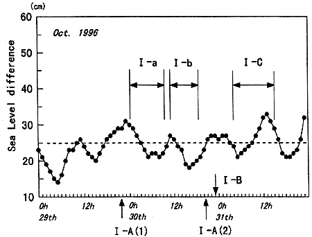
The daily sea level difference curve in Fig.2 shows that the difference was below the threshold value of 25 cm during the whole observation period of Cruise I (see Table 1 for details). The hourly sea level variation curve is shown in Fig.15 for the period from October 29 to October 31, 1996. The tidal signal is conspicuous at this time, and the sea level difference sporadically exceeds the threshold value. However, the level appears to be well below the threshold if we eliminate the tidal signal. Though both the Prompt Reports of Oceanic Condition of the last half of the October, 1996 and the first half of the November, 1996 indicate that the Kuroshio had the straight path, the daily and hourly sea level variation curves indicate that the oceanic condition would be very similar to that at the time of Kuroshio Large Meander. The satellite images taken in this period were not very clear, but the Prompt Report on Oceanic State from Satellite Images issued by the Wakayama Prefectural Fisheries Experimental Station reported that a small eddy (the magnitude of the eddy appears to be larger than that just after Cruise III) passed by Cape Shionomisaki.
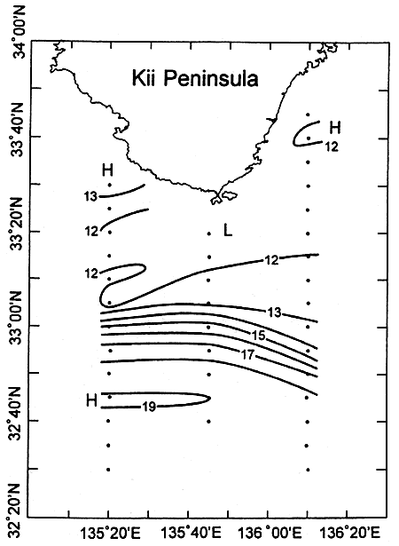
Fortunately, we conducted CTD observations along three north-south lines in Cruise I which are long enough to detect the position of the Kuroshio axis. The observation sites and the horizontal temperature distribution at the depth of 200 m are shown in Fig.16. A typical temperature distribution at a depth of 200 m at the time of the Kuroshio straight path is shown in Fig.1. This distribution is taken from the observations conducted on board the R/V Seisui-maru and the R/V Wakayama on June 11-14, 1996. The isotherms of 15℃and 16℃ run almost in the west-east direction in both Fig.16 and Fig.1, but the position of the Kuroshio axis is quite different in each case. A sharp Kuroshio front hits Cape Shionomisaki in June 1996, while a rather wide coastal zone can be seen between Cape Shionomisaki and the Kuroshio axis in October, 1996 (Cruise I). The position of the Kuroshio axis (15℃) measured southward from Cape Shionomisaki was about 50 km in October, 1996, and corresponds to the distance at the time of the Kuroshio Large Meander. Though the east-west scale of the eddy cannot be determined from the limited observation, the temporary departure of the Kuroshio axis from the coast occurred at the time of Cruise I.
The current profiles at 5 m (upper figure) and 50 m (lower figure) depths observed along the standard line, I-A(1), are shown in Fig.17. The current profile at 5 m depth would be classified into the Westward Current (Nobori-shio in Japanese: Takeuchi et al., 1998a), but that at 50 m shows a weak bifurcation tendency in the central portion. It should also be noted that a strong westward now exists just off Cape Shionomisaki at both depths: this return flow would be generated due to temporary departure of the Kuroshio axis from the coast. The current profile taken about one day later (I-A(2): Fig.18) is completely different from that of I-A(1) in Fig.17: the current profile would be classified to the Eastward Current, and the strong eastward current was recovered near Cape Shionomisaki.
Fig.15. Same as in Fig.7 except for Cruise I