We first discuss the results of Cruise II, as it appears to represent a typical oceanic condition at the time of the straight path of the Kuroshio, judging from the variable nature of the sea level difference. We then discuss the results of the other cruises in order of Cruise IV. Cruise III and Cruise I.
3. Structure and Temporal Variation of the Kii Bifurcation Current in the Period from June 24 to 26, 1997 (Cruise II)
3.1 Structure of the Kii Bifurcation Current
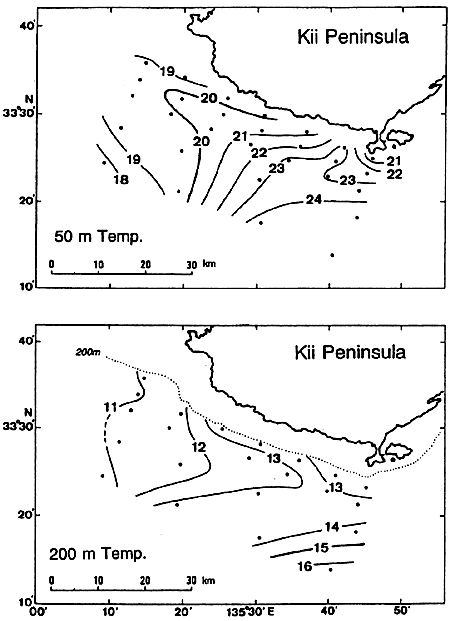
Current vectors measured along the five observation lines A through E in the period from June 24 to June 25 (Cruise II: see Table 1 for details) are shown in Fig.3 for three depths of 5 m (upper), 25 m (middle) and 75 m (lower). Temperature distributions at depths of 50 m and 200 m are shown in Fig.4. The current speeds at 75 m are lower than those at 5 m and at 25 m, but the horizontal current profiles are very similar to each other. A tendency of the current to bifurcate or diverge nature can be seen along each line and each depth, but it becomes clearer when the observation line approaches the coast.
The current distribution in Fig.3 indicates that the eastward flowing portion of the eastern half of the Kii Bifurcation Current corresponds to the shoreward edge of the current zone of the Kuroshio itself. The currents of the western half of the bifurcation current are directed rather northwards, and tend to flow into the Kii Channel. This portion might be related to the counter-clockwise eddy in the Kii Channel, which is usually observed when the Kuroshio takes the straight path (Fujita et al., 1998; Nagata et al., 1999a, b).
The tendency to bifurcation is also seen in the temperature field shown in Fig.4. It is known empirically that isotherms at 200 m depth roughly correspond to stream lines in the area south of Japan, and the 15℃ or 16℃ isotherm corresponds to the Kuroshio axis (e.g. Kawai, 1969; Kawabe, 1980). The lower part of Fig.4 shows the temperature domain between 13℃ and 14℃ branches between 135°35′E and 135°40′E, and one branch extends westwards, entering into the coastal area. The temperature field at 50 m depth indicates that the relatively warm water is carried westward along the coast by this branched current. Note the 15℃ or 16℃ isotherm does not bifurcate. This indicates that the bifurcation of the current occurs only in the shoreward edge of the current zone of the Kuroshio, and the main part of the Kuroshio is flowing continuously to the east.
3.2 Short time scale variability
Repeated observations along the standard line (Line A's) were conducted nine times (Runs II-A(1) through II-A(9)) in the period from 17: 11, June 25 to 13:57, June 26. The results are shown in Fig.5 for a depths of 5 m. The gross feature of the current structure was very stable during the repeated observations. However, the strength of the westward flowing portion of the western half of the Kii Bifurcation Current was enhanced in this repeated observation period in comparison with that observed at midnight on June 24 (Run II-A(0) in Fig.3), and a tendency to bifurcation can be seen more clearly.
The alongshore and onshore components averaged for each 1km segment for each run are shown in Fig.6 for the central portion of the standard line (35 km in length from 33°33.0′N, 135°23.0′E to 33°25.8′N, 135°44.1′E: the position is shown in the bottom of the right panel of Fig.5). The left panel of Fig.6 shows that the eastward current speed increases monotonically toward the east (negative value to positive value) for each run. The position where the sign of eastward speed changes indicates the bifurcation point. The fluctuations of tidal periods are hardly seen in this figure.