Appendix C: Supplementary Data on Operation Simulations
丂
Ice data
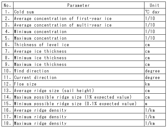
The data provided for the INSROP project by AARI is organized into average monthly values for the 38-year period from 1953 to 1990, divided into segments of 20NM in length and encompassing 18 parameters, which are listed in Table C-1. When the number of segments is multiplied with the number of years, months in each year and number of data parameters (I = 18), it is clear that this is an immense corpus of data. Since the segments number 130, the total number of data items is over a million: 130 亊 38 亊 12 亊 18 = 1,067,040. The data of cold-sum was supplemented with the data from polar stations. Data on ice concentration were gathered by aerial observation until 1978; in 1979, satellite observation took over. Parameter 6, thickness of level ice, was estimated according to an algorithm developed by Zubov, using the cold-sum data. The ice-thickness parameters 7-9 are average values including all types of ice, including multi-year ice; the average values were derived from the estimated ice thickness based on the observed values in May, when ice is thickest, and corrected for the growth and thawing rates during the year. The wind speeds and tidal flows are estimates based on forecast models. The floe size is classified into ten grades, using a model developed from aerial observation data. The average ridge sizes are estimated from the ice thickness, using the correlation between ice thickness and ridge sale height obtained from Romanov's data. The data in parameters 14 and 15 are estimates derived from average sail height distribution, which was assumed to follow the Weibull distribution. The parameters 16-18 are also estimates, derived from the correlation between observed values of ridge concentration given in five grades and the sail heights. For details, please refer to Breskin et al. (WP-121). All of this data is available on CD-ROM of INSROP GIS (1999), so that readers who need the actual data can access them. Ship speeds in the simulation were calculated using the seven parameters highlighted in bold face in Table C-1. Because observation was not possible in all areas, these data are both spatially and temporally incomplete. Overall, data is most incomplete for the eastern NSR, as sufficient observation was not feasible in some years. During the periods 1953-1956 and 1961-1964, the sufficiency rate for the observation data was 50% or lower, and these data were excluded from the base data for the simulation. Where data was not available or insufficient, an estimate was supplied using data supplemented from adjoining segments or the nearest few months. Unfortunately, the sufficiency rate for one of the important parameters, ridge density, was only 27%, so this sort of supplementation was impossible. In this case, an average value for all data was substituted for the missing ridge density data.
丂