丂
4.2.2 Aids to Navigation
(1) Infrastructures for aids to navigation
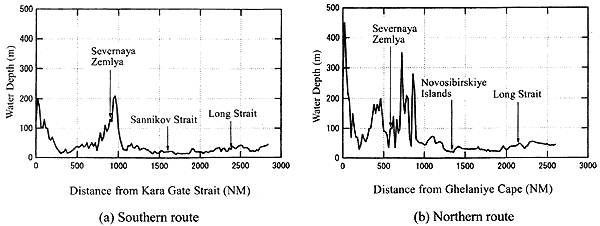
As explained in the previous section, the NSR is replete with hazards such as shallows and unseen rocks. In addition, a considerable volume of traffic links river traffic along the Ob and Yenisey Rivers with the NSR. These hazardous locations and areas of high traffic require the installation of various navigational aids at important waypoints, including radio beacons, unlit marks or day beacons, lighted marks, racons (radar beacons), radar reflectors and various buoys. Today, satellite-based ship position-finding systems are common and indispensable tools for navigation, and are as valuable in the NSR as in other shipping lanes.
Radio beacons are currently installed in 47 locations throughout the NSR, seventeen of which are manned stations. Two types of radio beacon are in use, one with a range of 100NM and the other with a range of 150NM; a new beacon with 300NM range is currently under development. At the same time, 30 locations mostly in the estuaries are outfitted with racons. A further 200 radar reflectors are also dotted along the coast. The reflectors are installed because the low, surrounding islands make radar navigation difficult. In many cases unlit or lighted marks are attached to the racons. Including this number of racons with marks, NR boasts some 250 lighted marks and 200 unlit marks. In the summer, some 1,000 floating marks are added.
The Global Positioning System (GPS) is a system for determining the precise location of objects using satellite data. Today this information is used not only by ships but by aircraft and even by automobiles, and GPS is a valuable system for ship positioning in the NSR as well. A similar system called GLONAS is used with Russian satellites, but in practice only Russian ships are outfitted with the electronic devices necessary to receive GLONAS signals. The GPS system, which was originally developed for military applications, is provided to civilian users with the capability to determine positions within at least 100m with 95% accuracy. To obtain more precise positioning, the DGPS mode was developed, in which the positioning data at land stations is compared with the data received by the ship to yield resolution as fine as 10m. In the NSR, DGPS land stations are planned for four locations to cover the Kara Sea: Oleny, Sterligov, Yugorskiy Shar and Lipatnikovo. The information gleaned from these land stations is used not only to ensure the safe passage of vessels through hazardous areas such as the Kara Gate Strait, but also to serve purposes such as oceanographic research and resource exploration and development.
The above information on various marks and satellite ship positioning systems is based on an INSROP research report (WP-108). This report can be thought of as a compilation of information as of 1998, but it should be borne in mind that many of these navigation aids may no longer be available for use, due to the recent economic upheavals in Russia.