Water at salinity lower than 24.7% has a point of maximum density higher than its freezing point and therefore freezes in the same way as freshwater lakes. This action causes layers to form just before the freezing point is reached, preventing mixing from convection. When such low-salinity water cools rapidly, therefore, sea ice can build up rapidly. To ensure safe navigation of the NSR, it is important to keep in mind the presence of these low-salinity water masses.
A map of areas of the Arctic Ocean with surface salinity of 2.5% or less is provided below. As the map indicates, large swaths of the Kara, Laptev and East Siberian Seas consist of such low-salinity water. Areas shaded with light diagonal lines have 2.5% or lower salinity in the summer, and areas shaded with thick diagonal lines have 25% or lower salinity in the winter. It should be noted that the pattern of freezing in vast areas of the NSR is similar to that of freshwater lakes, a phenomenon seen nowhere else in the world's seas except the Baltic Sea, and that ice in the beginning stages of freezing exhibits properties similar to those of freshwater ice.
丂
3.3.3 Sea Ice
The NSR is completely covered in ice for roughly six months of each year, from November to April, with the exception of some parts of the Barents Sea. Near the coastline is the "fast ice" (ice that is attached to the coastline), consisting of a mixture of one-year ice and multi-year ice. Beyond the fast ice is the much larger zone of drifting ice.
The summer lasts from June to September. During this time the sea ice melts rapidly, and both the extent and the strength of the ice cover decreases dramatically. The ice massifs, which appear every year in roughly the same locations, are mixtures of multi-year ice in the center of the Arctic Ocean and the accumulated remnants of the fast ice, which include many thickly rafting ice and ridges.
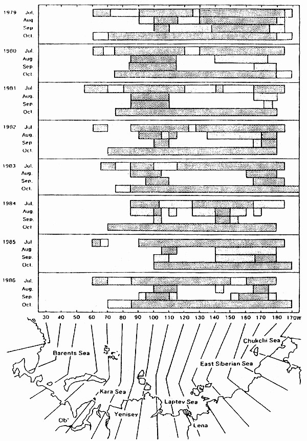
Using the satellite images taken with a microwave radiometer as described in 3.2.4, year-on-year changes in the status of sea ice extent in the summertime along the NSR area are shown in the diagram below. Based on satellite images taken in July and October of each year from 1979 to 1986, the presence/absence of sea ice was examined for each of several segments, 10亱 of latitude apart. In each year and month, areas where sea ice is present are enclosed in squares. Those with high concentration (70% or more) are indicated with dense hatching, and those with low concentration (less than 70%) are indicated with sparse hatching. In this diagram it is apparent that, except for 1979, in August and September, almost no sea ice was present in the Laptev Sea and the western part of the East Siberian Sea.
丂