3.1.10 Subarctic Coniferous Flora
The vast forests of the taiga sprawl across the subarctic landmass north of 60亱N, where temperatures sink below -40亷 and the days are almost completely dark during the winter. The word "taiga" comes from a Siberian indigenous word for "primeval (coniferous) forest," and is today extended to mean all of the coniferous forests distributed throughout the subarctic regions of the northern hemisphere. Siberia's taiga may be divided into two zones: the "light taiga," consisting largely of annual conifers such as larch, and the "dark taiga" characterized by perennial conifers. The Siberian taiga covers a larger area than the entire tropical forest of the Amazon basin.
The surface of the permafrost melts in the summer but freezes again in the winter, for which reason it is referred to as the "active layer. " Below this active layer lies the hard, frozen permafrost. Water cannot permeate the permafrost, so water that melts in the active layer stays there.
丂
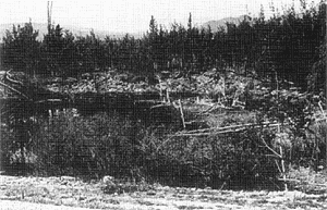
Subsidence caused by the growth of an alas
(Photo: National Institute of Polar Research)
丂
The roots of the larch support quite large trees even though they reach no more than 20cm into the soil of the active layer. When the melting of the active layer reaches the boundary of the permafrost layer, the trees easily topple and are rooted up. As the muddy surface of fallen trees and soil absorbs more solar radiation, the land caves in to form a depressed pond that destroys the subarctic vegetation. When permafrost melts, it shrinks and subsides to form a plate-like depression called an alas.
Water then collects in the depression, alas, and freezes during the following winter. In the next summer, when the alas melts again, much more water collects in the alas. The alas gradually grows through this seasonal process.
Over the course of many years, alas formations extend to depths ranging from 3m to 20m and can cover an area of 0.5-100km2. In areas covered with large volumes of ice, these bodies of water freeze in the winter and melt in the summer. The water that cannot penetrate deep into the soil collects in the ponds and lakes that dot the terrain over a wide area. These features can be seen around the North Slope of Alaska, which faces the Arctic Ocean. North of the subarctic forest, the active layer becomes thinner, and the woodland gives way to tundra where only the most stunted vegetation can grow.
丂
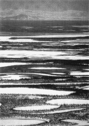
North Slope of Alaska
(Photo: National Institute of Polar Research)
丂
丂
丂
BACK丂丂丂CONTENTS丂丂丂NEXT
丂