丂
5. SUMMARY
丂
A compact imaging lidar system to be mounted in ships and airplanes with real-time display was designed and its prototype model was tested.
The system capability was surveyed and the effective range was estimated to be about 350m in daytime.
In order to interpret the data obtained in the field, the time-resolved fluorescence characteristics of chemical substances were measured with a streak scope in the laboratory. The time-resolved fluorescence characteristics of the oil show that the fluorescing organics in oil may be resolved into components according to the spectral and temporal characteristics fluorescence.
From image data of the trajectory of the water Raman scattering the in-situ measurement of the extinction coefficients was demonstrated to be used for oil film thickness estimation.
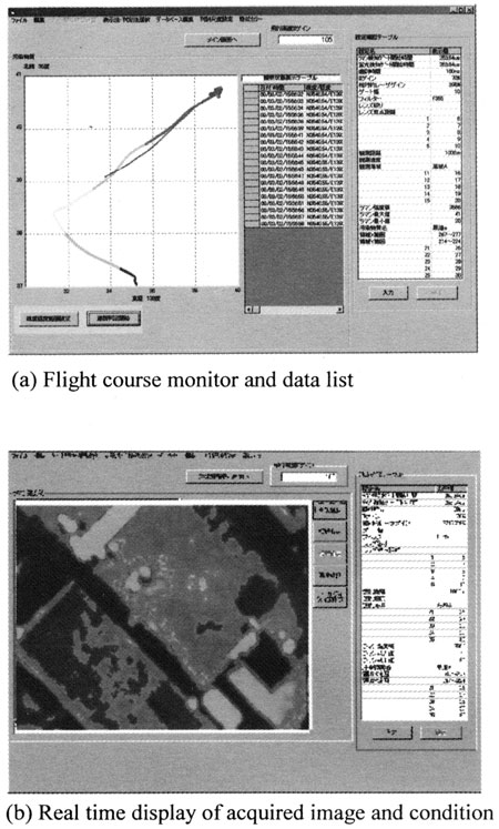
Air plane overflights recorded the laser illuminated spots in wide view of images using the proposed compact imaging lidar system.
Airborne and ship borne tests suggest that functions of the system for aerial and ship board performance may basically operate and can provide a real time display for an operator.
丂
Further tests will be necessary to be applied for practical use in various field conditions.
丂
Acknowledgement
丂
Primary support for this project came from the Japanese Ministry of Transport.
The authors gratefully acknowledge their cooperation of the Electronic Navigation Research Institute, and the Yuge National College of Marine Technology.
丂
6. REFERENCES
丂
[1] Measures, R.M. "Laser Remote Sensing"(1983)
[2] Browell, E.V. NASA TND-8447(1977)
[3] Hoge, F.E. and Swift, R.N. (1980) Appl. Optics, vol. 19, p3269
[4] Duntley, S.Q., AD-73072(1973)
[5] O'Neil, R.A. David A.R. Gross, H.G. and Kruus, J. NASA, Sp375, 173-195(1973)
[6] Hengstermann, T., and Reuter,R. EARSeL Advaces in Remote sensing., 1, 52-60
[7] Brown, C.E.,et al. Proc. of the 2nd Int. airborne remote Sensing Conference and Exhibition, ERIM Conferences, Ann Arbor, Michigan, III-683(1996b)
[8] Yamagishi, S. et al. Int. Oil Spill Conference #202 (1999)