The thermal front was weakened and moved cyclonically along the coast. The propagation speed of the temperature front can be estimated from the time lag and the distance from station to station. The distances between JG and KA. KA and HI, and HI and EN are about 20, 13, and 23 km, respectively. Thus the propagation speed is 0.69ms-1 between JG and KA, 0.60 ms-1 between KA and HI, and 0.64ms-1 between HI and EN. The estimated speeds are nearly equal to each other, that is, the thermal front moved along the coast with nearly constant speed of 0.6-0.7.ms-1. This speed is almost the same as the current speed observed at both EN and HI as well.
3.3. NOAA IR-image
The current and temperature records indicate a significant intrusion of warm water cyclonically along the bay coast. So, the wide spatial distribution of the warm water and its time change is useful for seeing the intrusion process and its horizontal scale. Fortunately, before the warm water intrusion, NOAA IR-images were taken with only a slight cloud cover in and around Sagami Bay. Fig.5 shows the images on January 4 and7, 1994. The time in Fig.5 is Japan Standard Time (JST). The red shading shows the area occupied by the warm water originating from the Kuroshio, whereas blueshows area occupied by the cold coastal or Oyashio waters. The yellow shows the water of intermediate temperature.
On January 4, the warm water did not intrude yet in the inner region of Sagami Bay, but slightly warmer water approached south of Sagami Bay. On January 7, the warm water already intruded into the bay through the Oshima west channel and occupied part of the eastern side of the bay. Most of the warm water flowed out to the Pacific Ocean through the Oshima east channel. These images clearly show the intrusion process of the Kuroshio water into Sagami Bay.
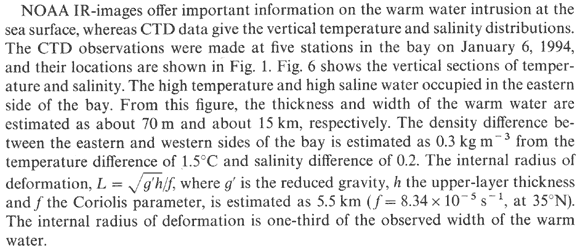
3.4. Vertical structure of temperature and salinity in the bay