In this example, the shift equates to approximately 230 metres which can be plotted at scale, larger than 1:1,000,000.
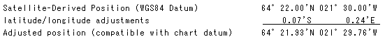
6 Where known, these adjustments are an average value for the whole area covered by the chart and are quoted to 2 decimal places of a minute in both latitude and longitude, so that the maximum uncertainty is about 10 metres in both latitude and longitude (0.005' and 0.014' will both be rounded to 0.01'). This uncertainty can be plotted at scales larger than 1:30,000 (where it is represented by 0.3 mm on the chart).
7 Inevitably, cases exist where overlapping charts show different latitude or longitude shift values. For example, one chart might show 0.06' and its neighbour 0.07; for each individual chart the value will be an average, but in the area common to both charts the value will range from 0.064' to 0.066'.
8 In the cases where an adjustment cannot be determined because of the lack of knowledge about the relationship between WGS84 Datum and the datum of the chart, the hydrographic office may add a note to that effect warning that adjustments "may be significant to navigation". The largest difference between satellite navigation derived and charted position reported so far is 7 miles in the Pacific Ocean, but even larger undiscovered differences may exist. Where charts do not contain any note about position adjustment it must not be assumed that no adjustment is required.
9 Most manufacturers of GPS receivers are now incorporating datum transformations into their software which enable users to (apparently) receive positions referred to datums other than WGS84 Datum. Unfortunately, many cases exist where a single transformation will not be accurate for a large regional datum. For example, the relationship between WGS84 Datum and European Datum (1950) is very different between the north and south of the region, despite the datum name being the same. Therefore, the position transformed to European Datum (1950) in the receiver by means of a Europe-wide average may differ from the WGS84 Datum position output by the receiver, amended to European Datum (1950) by the shift note on an individual chart. In the light of the 100 metre accuracy of the Standard Positioning Service of GPS this may not be significant, but it is an additional source of error and is of major significance if differential GPS (DGPS) is being used for navigation.
10 It must not be assumed that all charts in a region are referred to the regional datum. For example, although most metric charts of mainland European waters are referred to European Datum (1950), many charts are also referred to local datums. Additionaly, as there are no international standards defining the conversion parameters between different horizontal datums; the parameters used by the GPS devices may be different. The hydrographic offices use the best adopted parameters, so mariners are advised to keep their GPS receiver referred to WGS84 Datum and apply the datum adjustment note from the chart.